
Beantwoord enkele vragen, en binnen seconden geeft AI je een persoonlijk aankoopadvies op maat.
Beantwoord enkele vragen, en binnen seconden geeft AI je een persoonlijk aankoopadvies op maat.
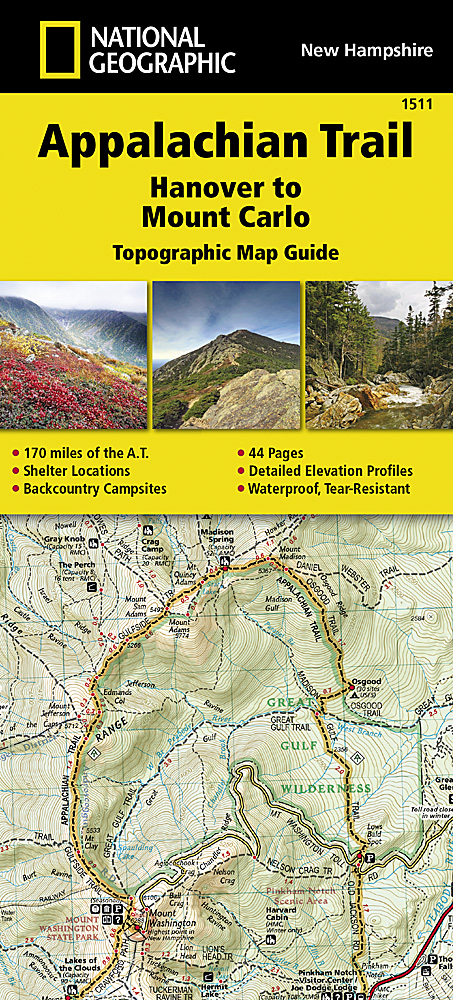
Wandelgids/wandelatlas met weinig tekst, maar goede kaarten van een gedeelte van de Appalachian Trail. Each A.T. Topographic Map Guide includes detailed topographic maps at a detail of 1 inch = 1 mile. Each page is centered on the A.T. and overlaps with the adjacent pages so there is little chance of getting lost. Along the bottom of each page is a trail profile that shows the distance between shelters, camping areas, and trail access points. The map and trail profile provide a step by step visual guide to hiking the trail, mile by rugged mile. The Topographic Map Guide is built for all levels of hiking enthusiasts, from the day tripper to the multi month 'thru-hiker'. The front pages of the printed Topographic Map Guide include resupply information, town inset maps, camping options, and much more. The Hanover to Mount Carlo Topographic Map Guide makes a perfect traveling companion when traversing the New Hampshire section of the Appalachian Trail (A.T.). The A.T. through New Hampshire is considered one of the more challenging sections of the trail, with long stretches above tree line and the possibility for rapid temperature change and snow any month of the year. But despite its difficulty, the trail offers some of the most spectacular scenery in New England as it leaves the Connecticut River valley to traverse the beautifully rugged White Mountains, a highlight of the A.T. Scale 1/63 360 (1 cm = 633 m). 1 inch = 1 mile. This topographic Map Guide is printed on a waterproof, tear-resistant paper. A full UTM grid is printed on the map to aid with GPS navigation.
€16,95
Bekijk product
Wandelgids/wandelatlas met weinig tekst, maar goede kaarten van een gedeelte van de Appalachian Trail. Each A.T. Topographic Map Guide includes detailed topographic maps at a detail of 1 inch = 1 mile. Each page is centered on the A.T. and overlaps with the adjacent pages so there is little chance of getting lost. Along the bottom of each page is a trail profile that shows the distance between shelters, camping areas, and trail access points. The map and trail profile provide a step by step visual guide to hiking the trail, mile by rugged mile. The Topographic Map Guide is built for all levels of hiking enthusiasts, from the day tripper to the multi month 'thru-hiker'. The front pages of the printed Topographic Map Guide include resupply information, town inset maps, camping options, and much more. The Pleasant Pond to Katahdin Topographic Map Guide makes a perfect traveling companion when traversing the northern Maine section of the Appalachian Trail (A.T.). The A.T. through Maine offers some of the most challenging sections of trail along the A.T., both in rugged terrain and weather conditions, and is not recommended for the unprepared hiker. Katahdin in Baxter State Park marks the A.T.’s northern terminus and for many hikers it also marks the end of a months long journey. Scale 1/63 360 (1 cm = 633 m). 1 inch = 1 mile. This topographic Map Guide is printed on a waterproof, tear-resistant paper. A full UTM grid is printed on the map to aid with GPS navigation.
€16,95
Bekijk product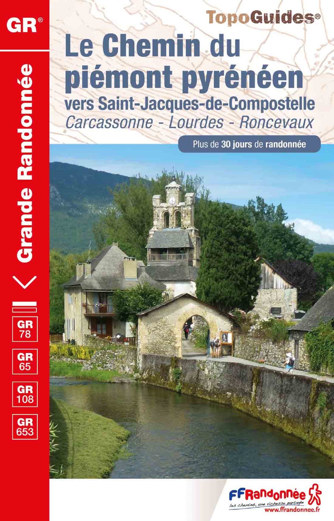
Uitstekende routegids met gedetailleerde kaarten en een routebeschrijving. Fout lopen wordt op deze manier wel erg moeilijk. Met symbolen is weergegeven welke voorzieningen (openbaar vervoer / winkels / overnachtingen) er zijn langs of bij de route. De gids bevat een lijst met overnachtingsadressen inclusief telefoonnummers. Alle gidsen bevatten een door ons toegevoegde uitgebreide frans - nederlandse wandelwoordenlijst. Carcassonne, Pamiers, Lourdes, Pau, Toulouse Encore peu connue, moins fréquentée que la voie du Puy et largement calquée sur d'anciennes voies romaines, la voie du piémont pyrénéen constitue une très belle alternative permettant de découvrir le riche patrimoine des Pyrénées en traversant de magnifiques paysages montagnards. L’itinéraire, le plus sudiste des chemins de Saint-Jacques, relie la Méditerranée à l'Atlantique en parcourant d'Est en Ouest, le Razès, l'Ariégeois, le Comminges, la Bigorre, le pays des Gaves. Des axes nord-sud permettent d'accéder aux cols de franchissement des Pyrénées par les vallées d'Aure, d'Ossau, d'Aspe (col du Somport vers l'Aragon) et à Saint-Jean-Pied-de-Port (col de Roncevaux vers la Navarre). C'est un chemin d'aventure peu connu et riche en patrimoine que l'on peut rejoindre en quittant la Voie d'Arles à Montpellier en direction de Narbonne par Saint-Thibéry et Béziers (Via Domitia).
€17,50
Bekijk product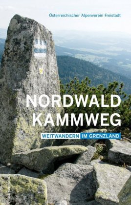
Goede gedetailleerde beschrijving van deze lange-afstands-wandelroute in het Oostenrijkse grensgebied van Duitsland - Tsjechie - Oostenrijk. Met veel kaarten (niet altijd genoeg detail, wandelkaart nodig) en praktische informatie als hoogteprofielen en beschrijving van de route. Der durch mystische Landschaften entlang der transkontinentalen Wasserscheide verlaufende Nordwaldkammweg an der tschechisch-österreichischen Grenze ist der älteste Weitwanderweg Österreichs. Er führt vom Dreisesselberg in Bayern zum Nebelstein in Niederösterreich und umfasst gemeinsam mit dem neuen Rückweg durch Südböhmen 14 Tagesetappen bei einer Gesamtlänge von rund 340 Kilometern. Der Weg führt durch nordisch anmutende, dichte, dunkle, moosige Wälder wie den Böhmerwald und den Sternwald, aber auch durch sehr liebliche Landstriche mit Wiesen und Weilern. Die höchsten Erhebungen sind der Dreisesselberg (1 312 m), der Plöckenstein (1 379 m), der Sternstein (1 122 m), der Viehberg (1 111 m) und derNebelstein (1 015 m). Der vorliegende neue Wanderführer beinhaltet erstmals auch den Rückweg durch das Grüne Band Europas (Nordwaldkammweg II und III).
€24,95
Bekijk product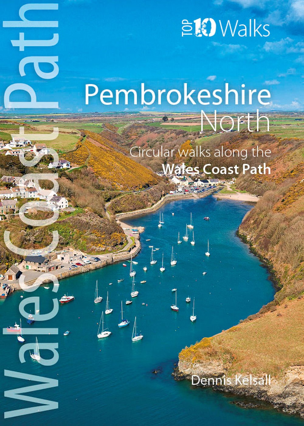
Zeer handzaam boekje van een tiental rondwandelingen, met goede kaarten en beschrijving. Leuke toevoeging op de route of als je alleen maar naar die streek gaat en op zoek bent naar mooie dagtochten. One of the series of books in the new Top 10 Walks: Wales Coast Path series. Handy, pocket-sized, full colour walking guides written by experts. Each volume outlines the most popular circular walks along key sections of the coast path. With clear information, an overview and introduction for each walk, expertly written numbered directions, enhanced Ordnance Survey maps, superb, eye-grabbing panoramic photographs, and interpretation of points of interest along the way, these guides set a new standard in reliability, clarity and ease-of-use. Featured walks include: Newport Bay, Dinas Island, Goodwick & Carregwastad, Strumble Head, Abercastle & Aberdraw, Porthgain & Abereiddy, St David's Head, Porth Clais & Whitesands Bay, St David's & St Non's, Solva.
€10,95
Bekijk product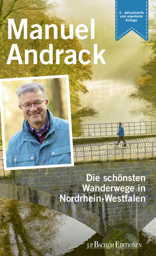
Duitstalige wandelgids met wandelingen in Nordrhein-Westfalen. Met informatie over openbaar vervoer Wanderexperte Manuel Andrack lädt in dieser aktualisierten und erweiterten Ausgabe erneut dazu ein, die schönsten Weitwander- und Prämienwanderwege Nordrhein-Westfalens zu entdecken. Neben den beliebten Wandersteigen präsentiert dieser Band auch wieder zahlreiche zertifizierte Rundtouren der Qualitätswanderregionen, z. B. die attraktiven Routen der Wasser.Wander.Welt am Niederrhein oder den Teutoschleifen. Neu hinzugekommen sind in dieser Ausgabe die Sauerland Waldroute und der erste Premiumweg des Ruhrgebiets, der 3-Türmeweg in Hagen. Andrack präsentiert den Lesern seine Highlights und verrät seine persönlichsten Tipps, etwas wo es das beste Bier oder den schönsten Fernblick gibt. Ein Buch für Wanderfreunde, Liebhaber guten Bieres und Fans des beliebten Manuel Andrack.
€17,50
Bekijk product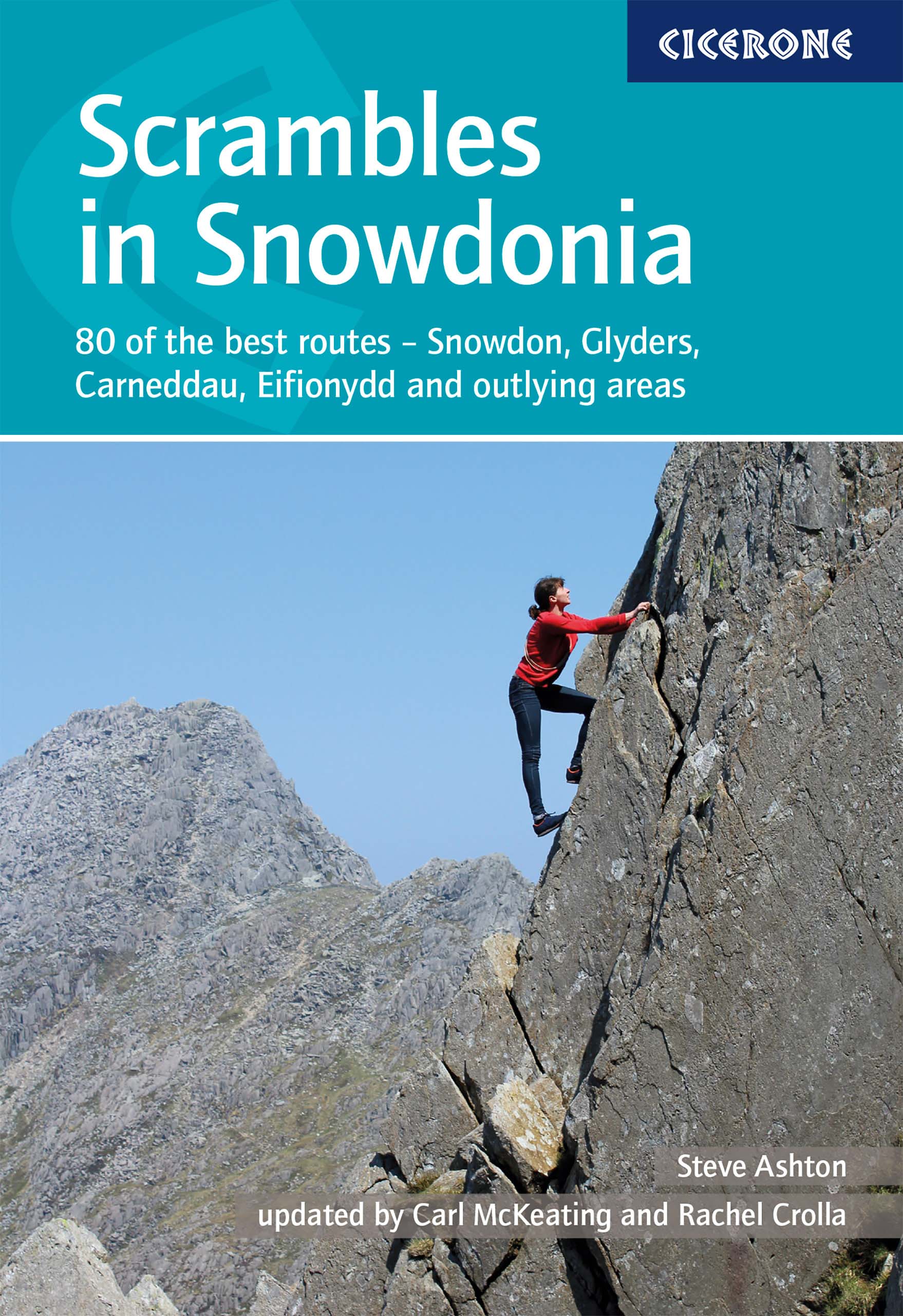
This revised edition of Steve Ashton's classic guide presents 80 scrambles in the stunning Snowdonia National Park, offering challenge, adventure and exhilaration, but also breathtaking scenery and an unparalleled opportunity to connect with the mountains of North Wales. The graded routes range from introductory traverses to demanding climbs involving technicality and exposure, recommended only for those with considerable experience, a strong head for heights and solid grounding in basic rope technique. It is now easier than ever to explore the Carneddau, Glyders and Snowdon Group, plus the finest scrambling in Eifionydd, the Moelwyns, Rhinogs and Cadair Idris. The favourites are all here – the Snowdon Horseshoe, North Ridge of Tryfan, Bristly Ridge and Cneifion and Cyfrwy Arêtes – as well as a number of lesser-known routes, including 16 not included in the previous guide. Photo topos illustrate the ascent routes, alongside comprehensive route description detailing the preferred line of ascent and descent options. Many routes also include ideas as to how scrambles might be combined to create longer outings, and summary information and overview statistics are provided to aid route selection. Dramatic colour photography completes the package. With advice on how to progress and stay safe, Scrambles in Snowdonia is an indispensable and comprehensive guide to enjoying the freedom and excitement of scrambling in the rugged Welsh mountains. Activities Scrambling, climbing Seasons Early March to the end of October Centres Most of the routes are in a small area, with Llanberis and the Ogwen Valley making good bases. The southern routes are accessed from Dolgellau. Difficulty Caters for both adventurous walkers and those seeking challenging mountaineering outings. There is a clear progression of difficulty. Grade 1 routes could be tackled by fit and experienced hill walkers. Grade 3 routes require knowledge of rope work and sound mountaineering judgement. All require a head for heights. Must See Includes all the classic routes such as the Snowdon Horseshoe with Crib Goch traverse, all the best routes on Tryfan, Bristly Ridge, Cneifion Arête, the Llech Ddu Spur, Nantlle Ridge and the Clogwyn y Person Arête. This revised edition covers an expanded area including Cyfrwy Arête on Cadair Idris and routes on Rhinog Fach and Fawr.
€20,95
Bekijk product
Uitstekende wandelgids van dit geweldige gebied. goed beschreven met veel praktische informatie om de route te kunnen lopen, inclusief redelijke kaarten. Walking in Kent describes 40 circular day walks in the Garden of England. This guidebook includes routes ranging from 5 to 9 miles in west Kent and The Weald and north and east Kent. Encompassing woodland walks, clifftop paths and riverside rambles, there is something for everyone, from family strollers and determined ramblers. No specialised equipment or clothing is required. The guide includes easy-to-follow route descriptions, 1:50K OS map extracts, background information and a route summary table. It also gives outlines of 11 longer walks in the Kent area, including the Darent Valley Way, the Saxon Shore Way and the North Downs Way National Trail. Kent is a wonderfully diverse county and these walks explore every corner, from the estuaries of the Medway and to the vast sweep of the Weald with its historic villages, orchards, hop gardens and vineyards. But best of all, there is the surprise of long unhindered views and big skies over Kent, where Britain begins.
€18,50
Bekijk product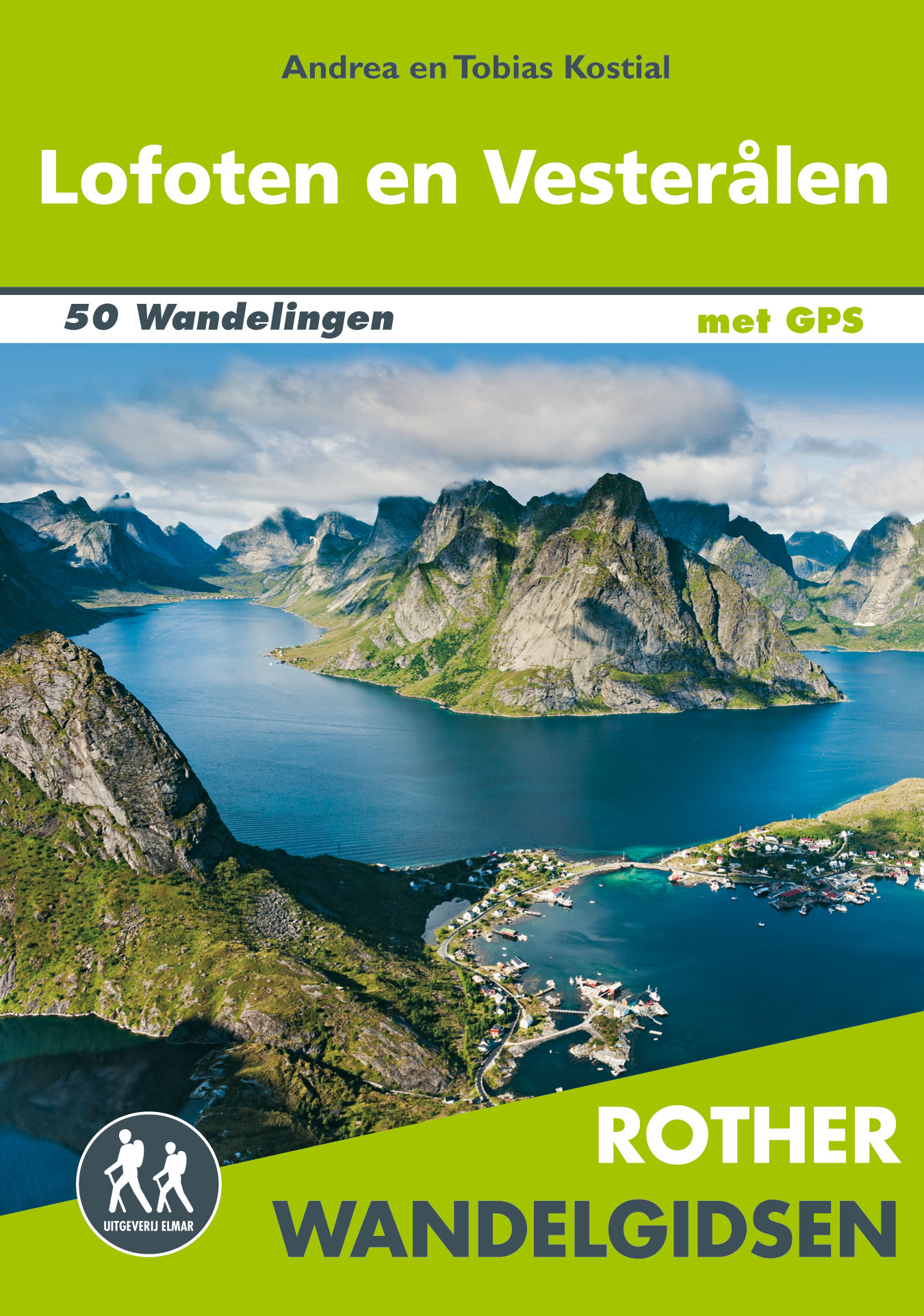
De Rother wandelgids Lofoten en de Vesterålen beschrijft de 50 mooiste kustwandelingen en uitzichtrijke bergtochten: wandelen in het licht van de middernachtzon op de archipels van de Lofoten en de Vesterålen. Zoals gebruikelijk zijn er verschillende wandelingen voor beginnende en ervaren wandelaars en is er onmisbare informatie over de streek, de bezienswaardigheden en recreatiemogelijkheden. De betrouwbare routebeschrijvingen, gedetailleerde kaarten en hoogteprofielen zorgen voor een onvergetelijke wandelervaring. Let op: er is enige verwarring omtrent het jaartal van deze Nederlandse wandelgidsen van uitgever Elmar. Dit is een vertaling van de Duitse uitgever Rother maar daarna NIET bijgewerkt. De datum die wij vermelden is het moment van vertaling; er zijn andere – meer recente jaartallen – in omloop maar dat is de datum van een nieuwe druk ZONDER aanpassingen. Wilt u de meest recente wandelgids van dit gebied van deze uitgever: kies dan de Duitstalige versie van uitgever Rother. Deze zijn recent en WEL bijgewerkt.
€19,99
Bekijk product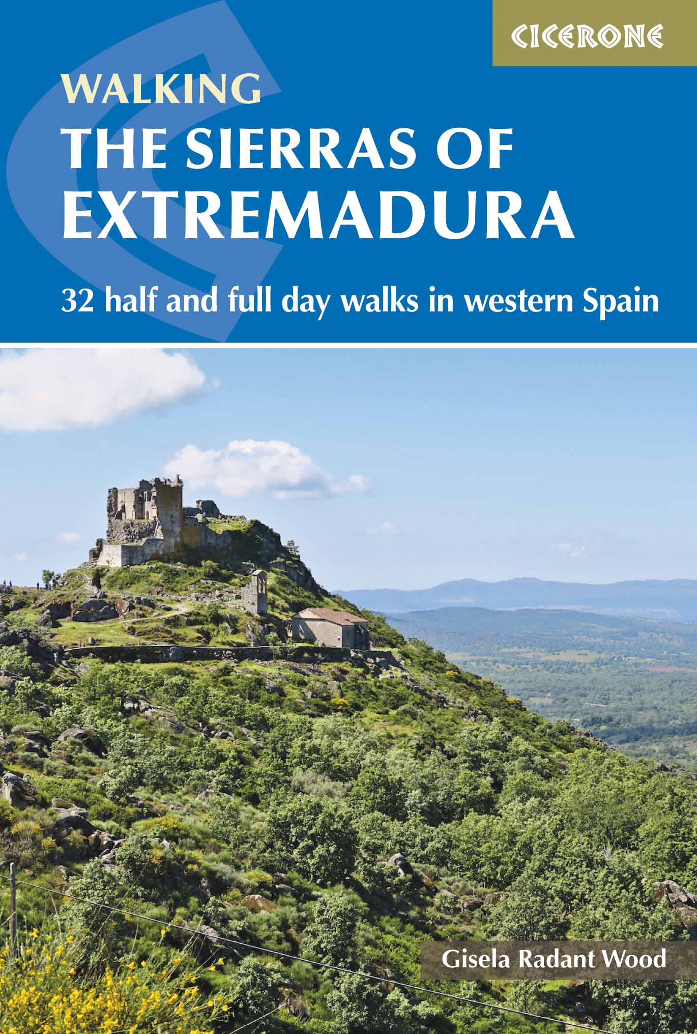
Uitstekende wandelgids, goed beschreven met veel praktische informatie om de route te kunnen lopen, inclusief redelijke kaarten This guidebook showcases 32 walks exploring the sierras of Cáceres and Badajoz, one of Spain’s least known regions and a gem for walkers and nature lovers. Walks range in length from 6 to 20km are suitable for any reasonably fit walker. They can be done from a number of bases in the area including San Martín de Trevejo, Gata, Hervás, Jerte, Jarandilla de la Vera, Montánchez, Guadalupe, Almoharín, Mérida, Alange, Hornachos and Monesterio. Each walk is accompanied by a sketch map and detailed route description, as well as notes on the terrain, refreshments available and access. Background information about the area and the many interesting sites passed along the route combine to give an invaluable guide to an unspoilt and peaceful region. Extremadura is one of the most untouched regions of Spain, a delightful mix of rugged mountain ranges, gently rolling hills, deciduous forests, deep river valleys, olive groves and shady pastures, all criss-crossed by thousands of paths. Superb birdlife and a variety of heritage sites, from cave paintings to monasteries, add to this region’s charms. Steden en Dorpen San Martín de Trevejo, Gata, La Garganta (Hervás), Jerte, Jarandilla de la Vera, Montánchez, Almoharín, Guadalupe, Mérida, Alange, Hornachos, Monesterio.
€23,95
Bekijk product