Beantwoord enkele vragen, en binnen seconden geeft AI je een persoonlijk aankoopadvies op maat.
Beantwoord enkele vragen, en binnen seconden geeft AI je een persoonlijk aankoopadvies op maat.
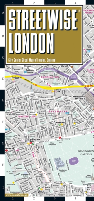
Handige stadsplattegrond van Londen in de vorm van een uitklapkaart, die aan twee zijden bedrukt is. Prettig leesbaar, helder kaartbeeld, met een register en een kleine kaart van het openbaar vervoer. Deze kaart is geplastificeerd. REVISED 2023Streetwise London Map is a laminated city center map of London, England. The accordion-fold pocket size travel map includes a London Underground map with tube lines & stations. Cover includes:Main London City Map 1:20,000London Underground Map - London Tube MapDimensions: 4" x 8.5" folded, 8.5" x unfoldedLondon is one of the most popular, populated and accessible cites on earth. People love London. And why not? Londoners are charming and helpful, and their city operates on such a high dosage of civility that it could be considered an art form. London is an urban oasis where you can search out cutting edge design, cuisine, fashion, chic neighborhoods, or traditional culture. When visiting London, be prepared to walk. Whether its basic window shopping, advanced people watching, or the rewarding task of locating restaurants and museums, London is urban roaming at its best. Days can be spent just visiting London's neighborhoods, each with its own character, atmosphere and unique offerings. The STREETWISE (R) Map of London UK will enable you to go anywhere in central London. The detailed and indexed depiction of streets, tube stations, sites and hotels will enable you to spend more time making new urban discoveries than less time complaining about disorientation. Say you choose Mayfair, for its refined and cultured demeanor. Take an afternoon stroll wandering through Berkeley Square, Grovesnor Square and Green Park then finish with an espresso at Rochaux's cafe. You'll briefly feel exclusive. Wander the back alleys in Soho and you will never know what or who you'll run across. The very trendy Covent Garden is dense with human interaction packed into a small area. Walk up to Bloomsbury with its literary heritage to be amazed by the vast holdings within the British Museum. The original city of London is the square mile of the city center, now the financial center as well. Immerse yourself in history and architecture with its many fantastic buildings beginning with St Paul's Cathedral on the western edge and ending at the Tower of London to the eastside. Hike over the Thames on the Tower Bridge to see the Design Museum and the HMS Belfast. You are now on the South Bank dominated by Waterloo Station and its surrounding shopping and dining area. The London Eye will provide an interesting overhead perspective of greater London. Come back to earth and walk the Thames along Queen's walk pedestrian path and you'll be rewarded upon finding Gabriel's Wharf, the Tate Modern, the famous wobbly Millennium Bridge and Shakespeare's Globe Theatre. Walk South through Hyde Park and you encounter Knightsbridge. It is one of London's most fashionable neighborhoods, the home of Harrod's (the Vatican of department stores) and Beauchamp Place, one of London's most fashionable shopping streets. If shopping is not on the agenda, there are museums like the Victoria & Albert, the Science Museum, and the Natural History Museum. South of Knightsbridge is Belgravia. This area has long been the aristocratic section of London, rivaling Mayfair in grandeur and tranquility. Our London street map is fully indexed with streets, concert halls, hotels, museums and galleries, parks, points of interest, shopping areas and transportation terminals. A separate inset map of the London Underground, the Tube, is also included to facilitate your travel around the city.
€9,95
Bekijk product
Der Stadtplan "Innsbruck 1:12.000" bietet zahlreiche Zusatzinformationen wie öffentliche Verkehrsmittel und Sehenswürdigkeiten. Im umfangreichen Index finden Sie außerdem jede Adresse. Alle Inhalte werden natürlich regelmäßig aktualisiert. Die Titel der "City Pocket" - Reihe passen durch das handliche Format von 9 x 15 cm in jede Tasche. Sie sind wasserfest und daher für jedes Abenteuer geeignet! Touristische Informationen The Big Five: Einkaufen / Kulinarik / Kultur / Nachtleben / Sehenswürdigkeiten; U-Bahnnetz, Straßenverzeichnis, Umgebungskarte;
€8,95
Bekijk product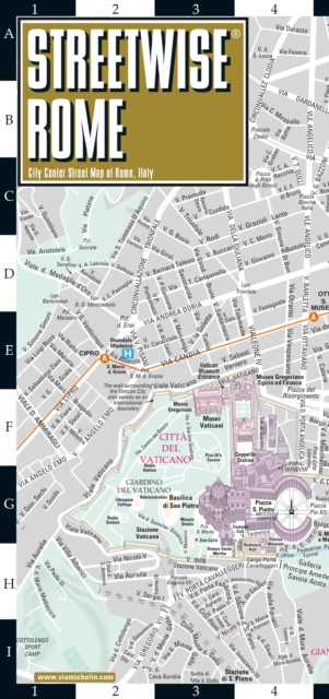
Handige stadsplattegrond van Rome in de vorm van een uitklapkaart, die aan twee zijden bedrukt is. Prettig leesbaar, helder kaartbeeld, met een register en een kleine kaart van het openbaar vervoer. Deze kaart is geplastificeerd REVISED 2023Streetwise Rome Map is a laminated city center map of Rome, Italy. The accordion-fold pocket size travel map has an integrated metro map including subway & railway lines and stations. Coverge includes:Main Rome Map 1:17,000Rome Historic District Map 1:8,700Rome Metro MapDimensions: 4" x 8.5" folded, 8.5" x 32" unfoldedA great map can be the key to discovering all the city has to offer. Our STREETWISE (R) Rome Map provides a comprehensive and fully detailed map of Rome to aid you in finding your way to all there is to do and see in this great center of history and culture. From Vatican City to the southeast corner of Palatine, the STREETWISE (R) Rome Map covers the entire city in full-color, including graphic representations of the major buildings and historic sites. The STREETWISE (R) Rome City Map is fully indexed, including streets, piazzas, gardens, and important places of interest. The STREETWISE (R) Rome Map also features a map of the Rome Metro system, including subway lines, railways, and the airport. Our pocket size map of Rome is laminated for durability and accordion folding for effortless use. For a more in depth look at the city, the Michelin Green Guide Rome helps you prioritize your time with its suggested itineraries and detailed descriptions of the sites and attractions you'll be visiting.
€10,50
Bekijk product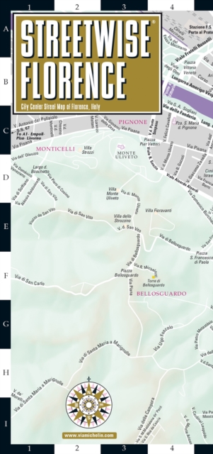
Handige stadsplattegrond van Florence in de vorm van een uitklapkaart, die aan twee zijden bedrukt is. Prettig leesbaar, helder kaartbeeld, met een register en een kleine kaart van het openbaar vervoer. Deze kaart is geplastificeerd REVISED 2023Streetwise Florence Map is a laminated city center map of Florence, Italy. The accordion-fold pocket size travel map includes train tracks & stations. Coverage includes:Main Florence, Italy Map 1:10,000Florence Area Map 1:150,000Central Florence Map 1:5,700Dimensions: 4" x 8.5" folded, 8.5" x 27" unfoldedFlorence is a city that should be discovered on foot. In order to cut down on the city center congestion, major sites are closed to car traffic (Santa Maria Novella and Duomo). Many of the major exhibits are in the outlying areas like Bagno a Ripoli, Fiescole, Figline and Scandicci. This has allowed visitors to discover less explored areas. Be sure to enjoy the Renaissance era through the beauty of the cathedrals, churches, museums, paintings, sculptures and frescoes of Florence. Not to be missed during your visit: Piazza del Duomo, the Uffizi Gallery, Palazzo Vecchio, Museo del Bargello, Chiesa di San Loreno and the Medici tombs, Galleria Palantina in the Palazzo Pitti, Museo di San Marco, and Frescoes by Ghirlandaio in Chiesa di Santa Maria Novella. STREETWISE (R) Florence Italy Map, complete with street, site and hotel index, enables you to explore each hidden corner of this city and to discover its historic importance and artistic richness on your own.
€9,95
Bekijk product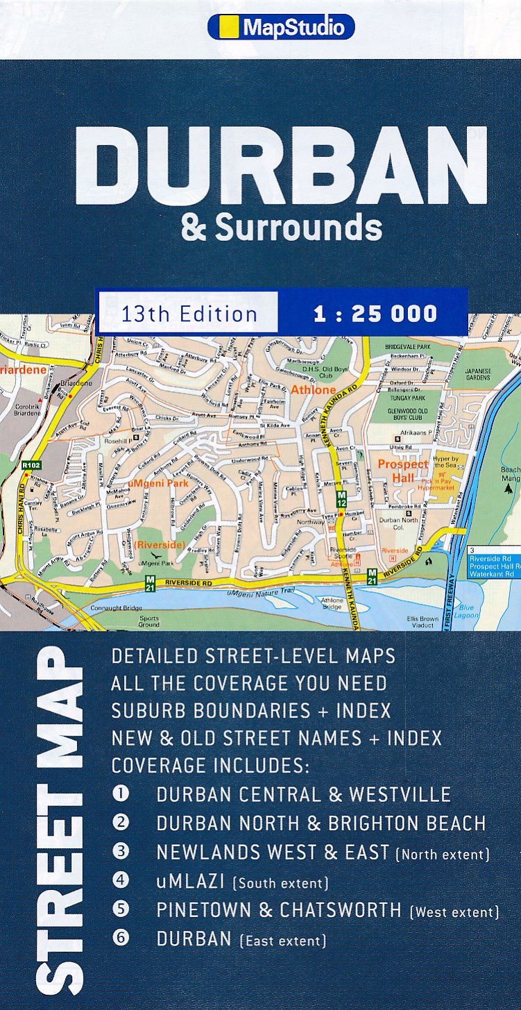
Duidelijke dubbelzijdige plattegrond van Durban en omliggende wijken met een uitgebreide index. Te vinden op de kaart zijn o.a. spoorlijnen + stations, hotels, campings, bezienswaardigheden en natuurreservaten. Detailed map of Durban at 1 : 25 000 scale; Kloof to Merewent; Durban CBD in detail; Indexed street & suburb names; index indicating new + old street names; main routes with route numbers, freeways & interchanges; schools; sports fields; hospitals / clinics & municipal clinics; shopping malls; police stations & fire departments; parks & Reserves; industrial areas; places of interest; historical monuments; provincial heritage sites; museums/art galleries; includes Moses Mabhida soccer stadium position.
€11,50
Bekijk product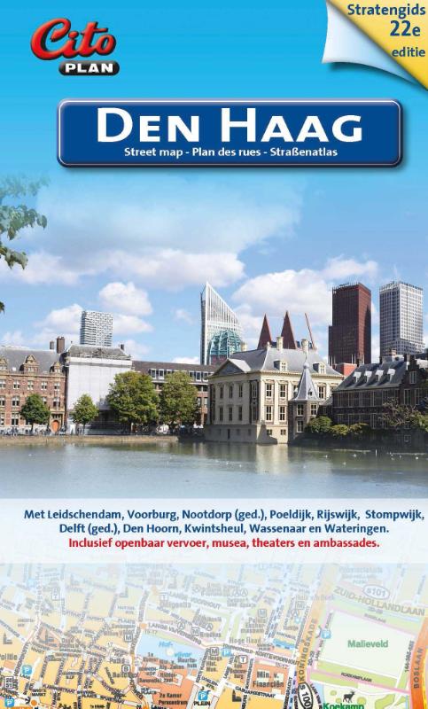
Stratengids van Den Haag in klein, handig formaat, gebonden met een spiraalband, met grote tekst en afbeeldingen. – viertalige legenda (Nederlands, Engels, Frans, Duits); dus ook voor de buitenlandse toerist ideaal! – praktisch voor wandelaar, fietser en automobilist – vergrote centrumkaart van Den Haag 1 : 7.500 – alle straatnamen, belangrijke en toeristische bestemmingen Met Delft (ged.), Den Hoorn, Kwintsheul, Leidschendam, Nootdorp (ged.), Poeldijk, Rijswijk, Stompwijk, Voorburg, Wassenaar en Wateringen
€11,50
Bekijk product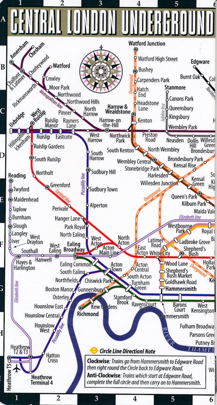
Streetwise London Underground Map is a laminated Tube map of London which conveniently folds to a pocket & wallet size metro map for travel. This map includes the following: London Tube Map with station index on the back. Travel gracefully throughout London with the STREETWISE London Underground Map. The entire London Underground is depicted on this easy to use, easy to carry map. Move through Mayfair, streak under SOHO, or pulse past Piccadilly with incredible agility, confident that you know where to go and how to get there using STREETWISE London Underground Map. Like all STREETWISE maps, this map of the London Underground is laminated to last and formatted to fit conveniently in your shirt pocket or purse.
€4,95
Bekijk product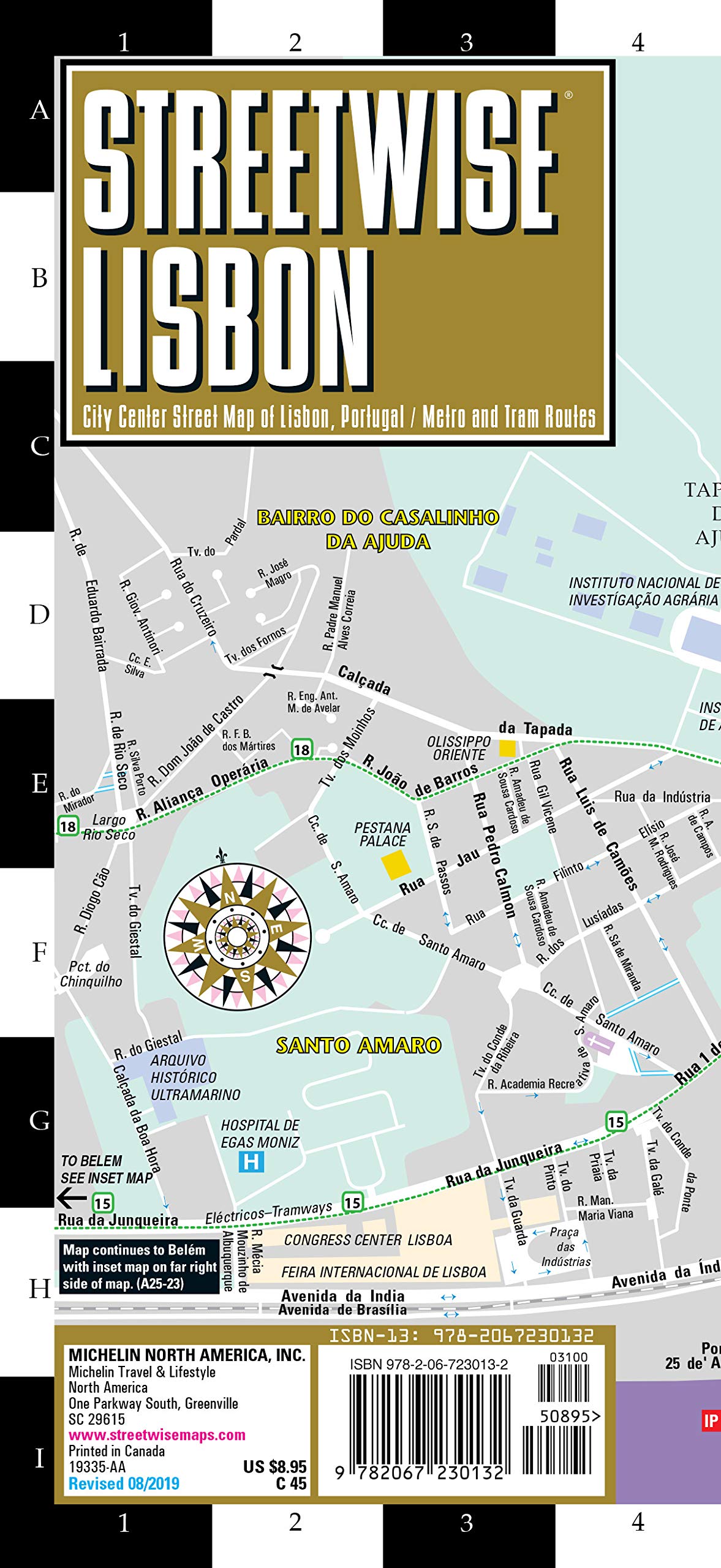
Michelin City Plans come in practical formats, paper, laminated and accordian folds. Suited for tourist use and with clear precise mapping. Starting at 1/8000 scale and upwards
€9,95
Bekijk product