
Beantwoord enkele vragen, en binnen seconden geeft AI je een persoonlijk aankoopadvies op maat.
Beantwoord enkele vragen, en binnen seconden geeft AI je een persoonlijk aankoopadvies op maat.

Een degelijke kaart met aanduidingen van o.a. nationale parken, vliegveld, benzinepomp, dirt-roads en kleine plattegrond van hoofdstad. Als overzichtskaart goed te gebruiken. Kazachstan 1:3.000.000 Usbekistan schaal 1:1.580.000 The Stans of the former Soviet empire are difficult to map because in the aftermath of liberation, most place names, which the Russian overlords had Russified were changed and not always to their original names or former spellings. Time has sorted out most nomenclature problems, and we hope that this version is letter perfect. In this updated edition for both countries, we have obviously tried our best to create a detailed and accurate map. The big difference between this edition and the previous one is the addition of Uzbekistan to the second side. The two countries seem to share certain common characteristics, as do the other three more easterly Stans, so we feel that combining similarities is better for end users than keeping separate sheets for each country. The advantage of this new map is that buyers get two country maps for the price of one. We feel that we also benefit, by providing end users with something that they need, affordably. Uzbekistan will continue to be available as a separate title. Legend Includes: Road by classification, Main Road, Shipping Route, National Park, Lake, Glacier, Salt Flat, Water Well, Point of Interest and much more...
€13,95
Bekijk product
Goede wegenkaart van Bali & Lombok. Aan beide kanten bedrukt. Met veel toeristische aanduidingen als nationale parken en culturele bezienswaardigheden. Prima leesbare kaart. One of six maps in a series covering Indonesia, this is a folded road and tourist map of the two Indonesian islands of Bali and Lombok at 1:180 000 scale. Parks, beaches, and places of interest are all highlighted and shaded-relief coloyring clearly depicts the topography. The map includes insets showing Ubud and it's surroundings at 1:33 000, Denpasar at 1:20 000, Kuta at 1:20 000, Lovina Beach at 1:30 000, Sanur at 1:35 000, Nusa Dua at 1:50 000, the Gili Islands at 1:55 000, Mataram at 1:50 000 and an overview locator map. The legend is in English, French and German. For over 20 years Nelles maps have been renowned throughout the world for their quality, faithfulness to detail and up-to-dateness. So that streets, ferry links, railway lines, etc are always up to date, Nelles are continuously upgrading their maps - with the help of their international team of correspondents. Roads are provided with an exact kilometerage. Sights are highlighted extra clearly so that you don't miss any tourist attractions. A good map must be hard-wearing and allow itself to be folded up simply and quickly. Nelles Maps are a handy pocket size with the reliable, practical concertina fold. In addition they use an extra high-quality speciality paper resulting in considerably increased fold strength. Gili Islands (Gili Trawangan. Gili Meno. Gili Air) 1 : 55.000 Ubud and Surroundings 1 : 33.000 Denpasar 1 : 20.000 Kuta / Legian 1 : 20.000 Lovina Beach 1 : 30.000 Mataram 1 : 50.000 Nusa Dua 1 : 50.000 Sanur 1 : 35.000
€10,95
Bekijk product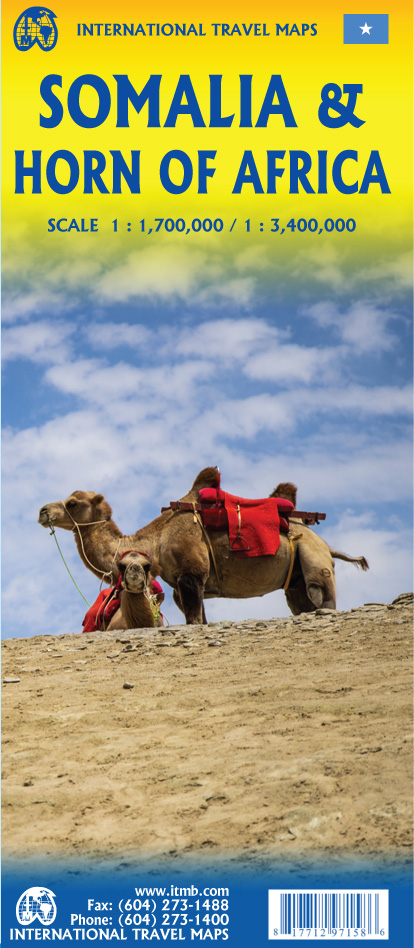
Een degelijke kaart met aanduidingen van o.a. nationale parken, vliegveld, benzinepomp, dirt-roads en kleine plattegrond van hoofdstad. Als overzichtskaart goed te gebruiken. Met aan de ene zijde een kaart van Somalië, schaal 1:1.700.000, en op de andere zijde een overzichtskaart van de Hoorn van Afrika, schaal 1:3.400.000 Somalia is one of the more interesting off-the-beaten-path countries. The area around Mogadishu prefers to call itself Somalia, but controls only a portion of the overall country area. Then there is Jubaland, on the Kenyan border, aligned very closely to the former Italian colony boundaries of the same name. Truly, an amazing juxtaposition of countries within countries! The reverse side of the sheet presents a very interesting regional perspective of the area between the northern border of Ethiopia, a small portion of Sudan and a reasonable portion of South Sudan, all of Uganda, most of Kenya, all of Djibouti, and a fair portion of Eritrea, as well as the former Aden portion of war-torn Yemen. The strategic island of Socotra is in the upper right corner. This is a fascinating regional map, never before published to my knowledge, of an extremely significant part of the world. Think of the following: Socotra guards and controls access to the Gulf of Aden and the Red Sea, leading to the Suez Canal. What an interesting part of the world! How can anyone not be captivated by such wonderfully exotic names as Hargeysa, Boosaaso, or Kismayyo? Somalia and the region of the Horn remain crucially important to world peace, so this map is important. Legend Includes: Roads by classification, Rivers and Lakes, National Park, Airports, Points of Interests, Mining, Highways, Main Roads, Zoos, Fishing, , and much more...
€13,95
Bekijk product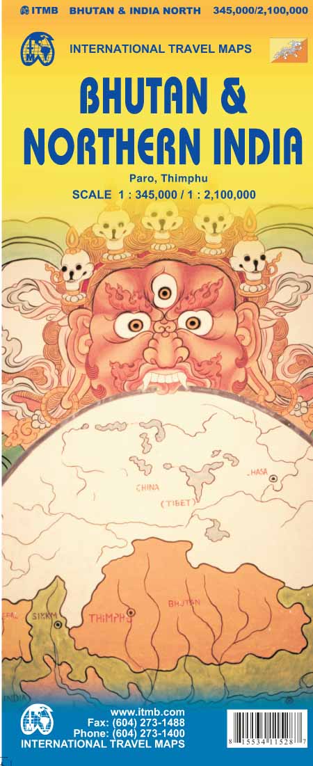
Een degelijke kaart met aanduidingen van o.a. nationale parken, vliegveld, benzinepomp, dirt-roads en kleine plattegronden van Thimphu, Paro en Calcutta. Als overzichtskaart goed te gebruiken. De ene kant van de kaart heeft Bhutan erop staan, met een schaal van 1:35.000. De andere kant van de kaart omvat noordoost India. Schaal 1:1.300.000 Bhutan is a beautiful mountainous country, squeezed between India and China. It is not a part of the world experiencing significant change, and this version is pretty much the same as our previous one, although updated with minor changes. Printed double-sided, with Northeast India on the other side. Legend Includes: Roads by classification, Express Way, National Highway, Major Highway, Secondary Road, Other road/track, Railway, Ferry Route , State Boundary, Undefined Boundary, River and Lake, Glacier, Desert/ swamp, Mountain peak, Pass, Historical Site, Monument, Bhuddist Monument, Radio Tower, Post Office, Police Station, Hospital, Library, Embassy, Gas Station, Bank, Shopping Centre/Market, Fort, Lighthouse, Broadcasting Station, Telephone, Camping Site, Hostel, Notable Building, Cinema, School, Bus Terminal, Stadium, International Airport, Domestic airport, Harbour, Ferry, Border Crossing, Bridge, Resort, Notable building, Monastery, Bhuddist Temple, Hindhu Temple, Palace, Tourists info Center, Beach, Cave, Crosscounty Skiing, Garden, Golf Course, Hill Station, Ruins, rafting, Viewpoint, Wildlife Reserve, Zoo, Point of Interest, Natural point of interest, Cultural World Heritage Site, Natural world Heritage Site, Northern India Population, Capital and much more
€13,95
Bekijk product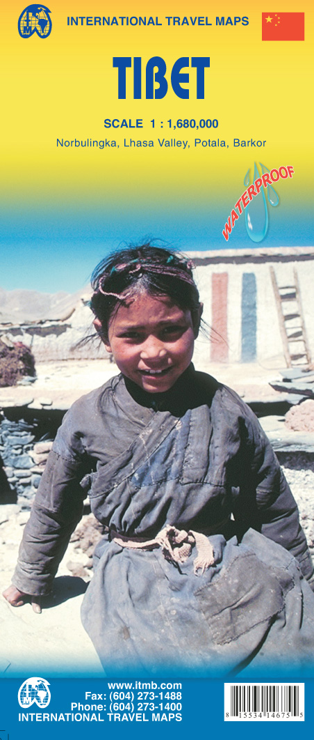
Een degelijke kaart met aanduidingen van o.a. nationale parken, vliegveld, benzinepomp, dirt-roads en kleine plattegrond van hoofdstad. Als overzichtskaart goed te gebruiken. Tibet is fascinating and controversial. It has been occupied by China since Chairman Mao send hordes of Chinese troops into the country and annexed it to China, expanding its borders somewhat by over-running parts of northern India a bit later. We do our best to portray the country as it is, without getting overly involved in the political ramifications, which are pretty severe. At the moment, the Chinese authorities seem to be clamping down on tourism, due to simmering unrest. However, the country, or self-governing province of China is a beautiful place and deserves a good map. It is extremely difficult to get updating information on Tibet; we've done our best, but this is very much a work in progress. Printed on ITM plastic for durability, with a new ISBN and cover picture. Legend Includes: Roads by classification, International Border, Disputed Border, Province/region Border, Prefecture Border, Railway, Motorway, Main Road, Connecting Road, Other Road, Track, Glacier, Salt Pan, Swamp, Sand, Pass, Mountain, National Park, Wildlife Reserve, International Airport, Airport/Airfield, Point of Interest, Ruin, Hill Station, Hermitage, Monastery, Museum, Zoo, Winter Sport, Fortress, Ferry, Hot Spring, Cave and much more
€13,95
Bekijk product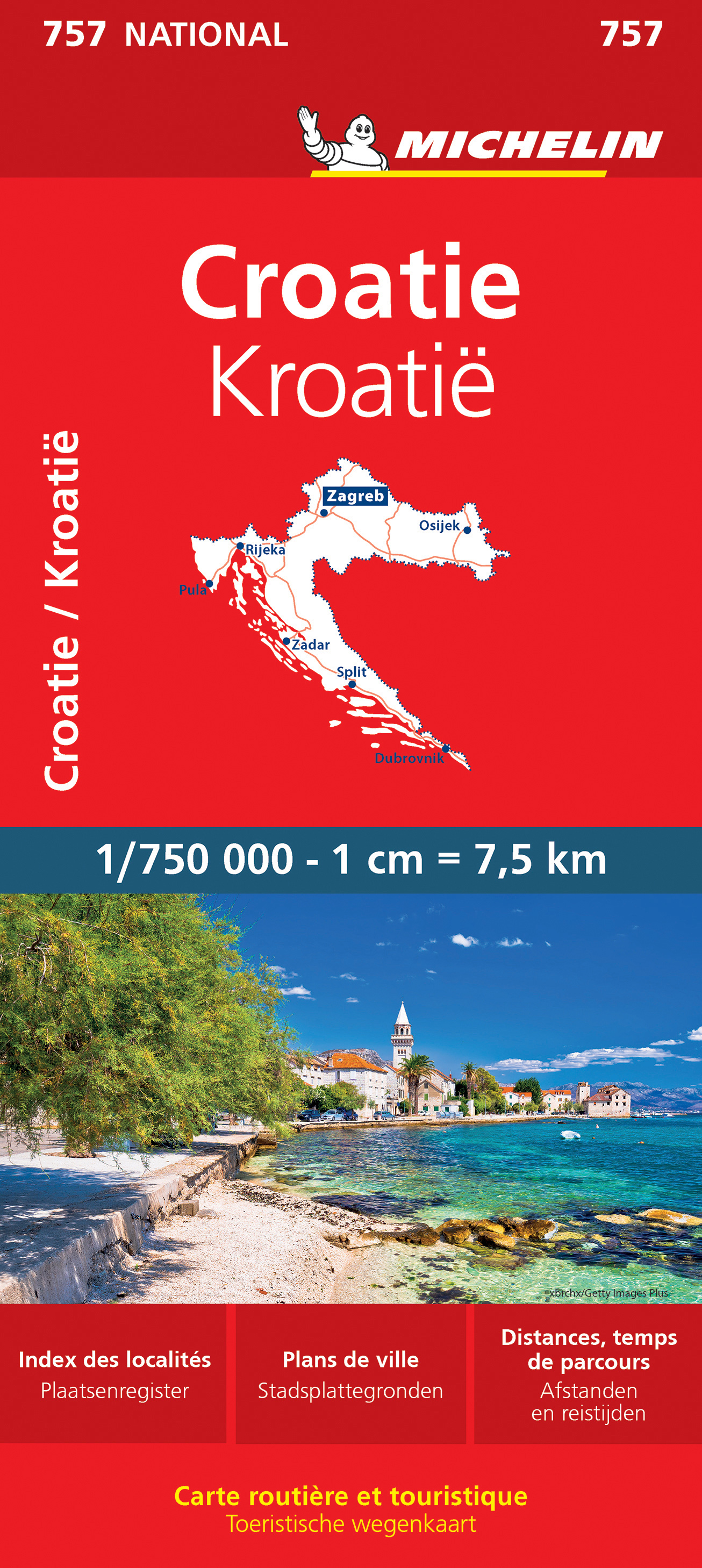
Zoals je van Michelin mag verwachten is deze kaart zeer overzichtelijk en heeft een duidelijk helder kaartbeeld. De kaart geeft uitgebreid toeristische informatie weer. Met register, afstanden en reistijden. Wegen worden naar verschillende klasse ingedeeld en - mooi van Michelin - de interessante mooie routes worden gemarkeerd met een groene streep. Hindernissen voor automobilsiten met caravans zijn gemarkeerd: steile hellingen, bergpassen of een anderzins moeilijke route. Bezienswaardigheden als een kasteel, religieus gebouw, ruine of grot is door een symbool goed te vinden. Van de uitgever Une carte routière et touristique Michelin pour être maître de votre itinéraire : - Mise à jour régulièrement - Une vue d'ensemble claire de la Croatie - Une cartographie précise et ultra lisible - Echelle : 1/750 000 (1cm = 7, 5km) - Format : 11. 3 x 0. 9 x 25 cm - Les plus : tableau des distances et des temps de parcours, index des localités, légende intuitive - Plans : Dubrovnik, Zagreb Pensez à utiliser en complément notre Guide Vert Croatie, notre Carte National Slovénie, Croatie, Bosnie-Herzégovine, Serbie, Monténégro, Macédoine. Avec la carte MICHELIN trouvez bien plus que votre route ! Croatie, Dubrovnik, Zagreb
€11,95
Bekijk product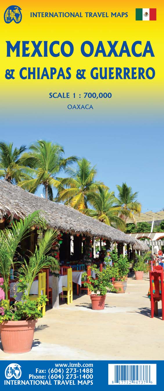
Folded road and travel map, in color. Scale 1:700,000. Distinguishes roads ranging from expressways (free/toll) to rural roads. Legend includes tracks, trails, international airports, domestic airports, airfields, gas stations, points of interest, archaeological sites, caves, beaches, lighthouses, mines, national parks, swamps, mangroves. Includes inset map of Oaxaca City Downtown Legend Includes: Airports, roads by classifications, distances between points, gas station, point of interests, archaeological sites, beaches, lighthouses, hypsography and other information.
€13,95
Bekijk product
Mexico is one of our favourite places to visit, and is also very popular with American travelers. The five states that border Texas – Coahuila, Nuevo Leon, Tamaulipas, Zacatecas, and San Luis Potosi may not be well-known internationally, but Monterrey (the third largest city in Mexico), Nuevo Laredo, Matamoros, Torreon, Tampico, Aguascalientes, and Ciudad Victoria evoke images of the Mexico of ranches and vast distances. This is actually a fertile and economically developing part of the country, bordered by the Gulf of Mexico on the east, Texas on the north, and ITMB’s maps of Central Mexico on the south and our new map of Sonora and Chihuahua States on the west. This is an excellent map for cross-border expeditions; printed single-sided, on paper, showing main and secondary road connections, rail lines, gas stations in smaller towns, and whatever tourist attractions we were able to locate. Legend Includes: Airports, roads by classifications, distances between points, gas station, point of interests, archaeological sites, hypsography and other information.
€13,95
Bekijk product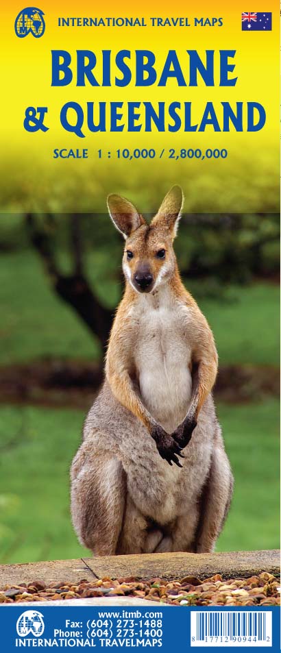
Australia is a very large country. It is also very unevenly populated, with most of the people living close to the eastern coast. Brisbane is the second-largest city in Australia, and the preferred landing spot for most international flights. This makes Brisbane an attractive point of entry to Australia for visitors. The city has several attractions, which are noted on the map, several transit lines, also noted, and an interesting ferry boat system along the Brisbane River. The city is also the capital of Queensland, which occupies the north-east quarter of the continent and fills the second side of the map. Our map of the state stretches from the northern tip of Cape York to beyond the southern boundary of the state to just south of Sydney, in New South Wales. An inset map of central Sydney is included, but the strength of the map is the fact that Queensland is covered in excellent detail. ITMB also has a separate map of Sydney. Legend Includes: Roads by classification, Rivers and Lakes, National Park, Airports, Points of Interests, Mining, Highways, Main Roads, Zoos, Fishing, , and much more...
€13,95
Bekijk product
Zoals je van Michelin mag verwachten is deze kaart zeer overzichtelijk en heeft een duidelijk helder kaartbeeld. De kaart geeft uitgebreid toeristische informatie weer. Met register, afstanden en reistijden. Wegen worden naar verschillende klasse ingedeeld en - mooi van Michelin - de interessante mooie routes worden gemarkeerd met een groene streep. Hindernissen voor automobilsiten met caravans zijn gemarkeerd: steile hellingen, bergpassen of een anderzins moeilijke route. Bezienswaardigheden als een kasteel, religieus gebouw, ruine of grot is door een symbool goed te vinden. This USA map from Michelin is part of their red national map series. These are perfect for route planning as well as getting around by car once you're there. They clearly mark out major roads and also show many of the more important minor roads. Alaska and Hawaii are inlcuded as insets. The map's simple folding design with durable paper cover, allows it to be read like a book and easily folded back together. Road numbers and intermediate distances are clearly displayed with the more scenic routes highlighted in green. The map also features: Political boundaries Regional and National Parks Important sights (points of interest, historic sites, etc.) Driving Times and Distances Road Safety Information A legend in multiple languages (Dutch, English, French, German and Spanish) Boston, Chicago, Etats-Unis, Los Angeles, New York, San Franciso, Seattle, Washington
€12,95
Bekijk product