
Beantwoord enkele vragen, en binnen seconden geeft AI je een persoonlijk aankoopadvies op maat.
Beantwoord enkele vragen, en binnen seconden geeft AI je een persoonlijk aankoopadvies op maat.

Makkelijk leesbare kaart aan 2 zijden bedrukt. De ene kan met informatie en beperkte stadsplattegronden, de andere met de daadwerkelijke kaart. De kaart is geplastificeerd en dus watervast! The front side is an easy-to-read road map with insets of: - Covington, KY / Cincinnati, OH - Land Between the Lakes - Owensboro - Bowling Green - Frankfort The back includes: - Maps and information for Louisville and Lexington - Points of interest - Information for Mammoth Cave National Park - Scenic drive - Park Service sites for Kentucky
€12,95
Bekijk product
Makkelijk leesbare kaart aan 2 zijden bedrukt. De ene kan met informatie en beperkte stadsplattegronden, de andere met de daadwerkelijke kaart. De kaart is geplastificeerd en dus watervast! The front side is an easy-to-read road map with insets of: - Athens - Augusta - Albany - Savannah - Brunswick / Jekyll Island - Columbus - Macon The back includes: - Points of interest - Information and map of Atlanta - Information for Okefenokee National Wildlife Refuge and Swamp Park - Scenic drive - Park Service sites in Georgia
€12,95
Bekijk product
Makkelijk leesbare kaart aan 2 zijden bedrukt. De ene kan met informatie en beperkte stadsplattegronden, de andere met de daadwerkelijke kaart. De kaart is geplastificeerd en dus watervast! The front side is an easy-to-read road map with insets of: - Pensacola - Jacksonville - Panama City - Tampa / St. Petersburg area - Miami area - Daytona Beach - Tallahassee - Gainesville - Fort Myers / Cape Coral The back includes: - Points of interest - Scenic drive - Information for Miami / Miami Beach, Orlando, and Key West - Information on Everglades National Park - Park Service sites in Florida
€12,95
Bekijk product
Zeer goede overzichtskaart van het hele gebied van Vietnam, Laos en Cambodja. Zeker als je meerdere landen gaat combineren is dit een prima kaart waar nog veel op staat. Veel plaatsen, maar ook allerlei toeristisch interessante plekken die met symbolen zijn aangegeven. Detailed, double-sided road map Vietnam, Cambodia, and Laos, ideal for route-planning. Clearly shows the national road network and selected provincial and local roads, with each class of road clearly indicated and road numbers shown. Intermediate driving distances between locations are shown in kilometres alongside the road, motorway filling stations are shown and motorway junctions are indicated. Topography is shown with relief shading and some spot heights. International and provincial boundaries are clearly marked, as are National Parks, nature reserves and restricted military areas. Symbols indicate various sights & locations of tourist interest, such as churches, leisure & sports destinations, panoramas & viewing points, monuments and historic sites. Some hotels and campsites are marked. Railway lines, airports, ports, reefs and marinas are also shown. A grid divides the map at 1° increments, and is also grid-referenced for the map index. Multilingual map legend includes English.
€14,95
Bekijk product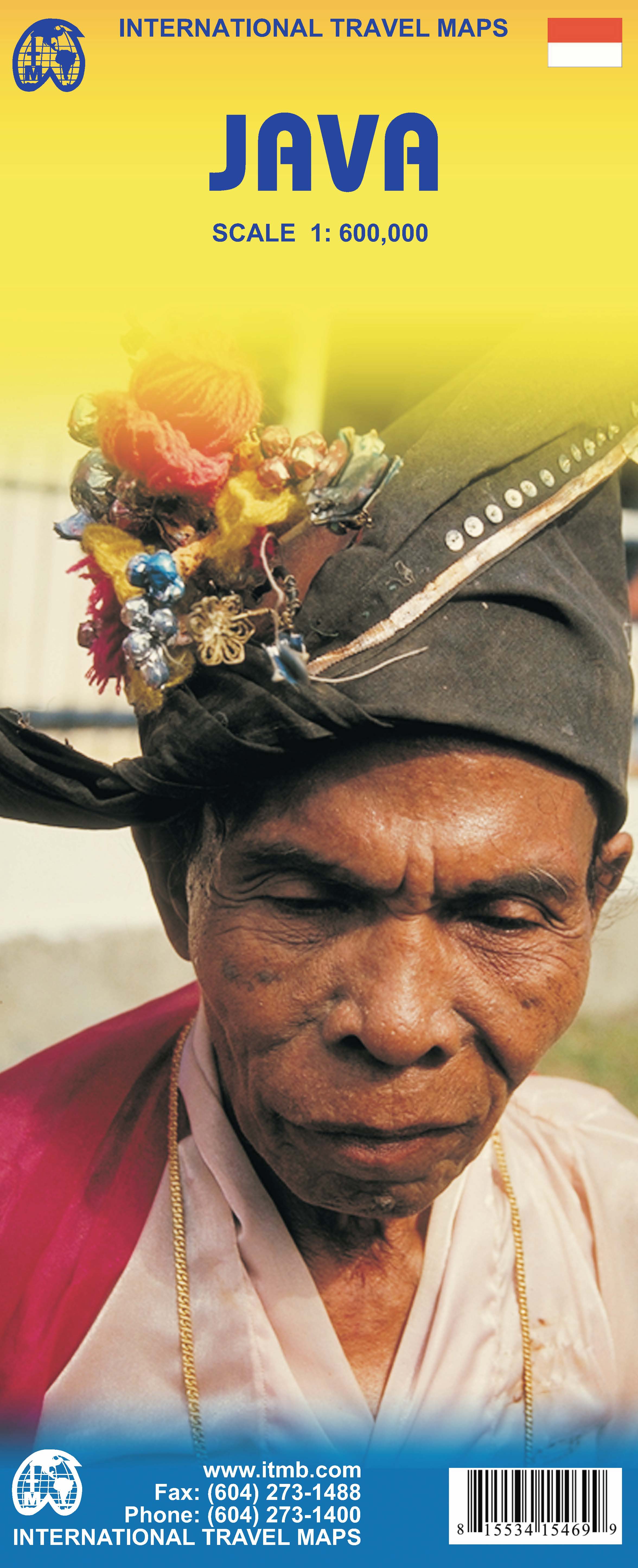
Indonesia is a huge and varied country of many islands and many cultures. The Javanese dominate the country. Not only is the island centrally located, but the rich soil and hard-working people has turned the island into the economic powerhouse driving the country’s economy. Indonesia’s capital, Jakarta, is located on the island’s north shore, and is the subject of a separate ITM map. This map concentrates on the island’s many charms: the temples of Yogyakarta, the colonial architecture of Surabaya, and the rustic charm of mountainous East Java. The map abounds in insets, including central Jakarta at 1:25 000, but also Cirebon, Bandung, and Solo, Semarang, Surabaya, Yogyakarta, Malang, and Yoga to Prambanan at 1:90,000, and the Dieng Plateau at 1:35,000. The famous island of Krakatoa is also included. This map is double-sided (east/west). Roads by classification, ferry route, ruins, bird sanctuary, national parks, volcanoes, non-active volcanoes, hotel, surfing, beaches, waterfalls, hindu temples, buddist temples, mosques, bus terminal, museums, shopping centres, tourist information, points of interest and other information.
€13,95
Bekijk product
Zoals je van Michelin mag verwachten zijn het onmisbare overzichtskaarten van een uitstekende kwaliteit: een duidelijk en goed leesbaar kaartbeeld. Vrijwel alle berijdbare wegen staan er op ingetekend, in kleur verschillend voor grote en kleine wegen. Andere weginformatie omvat bijvoorbeeld kilometer-afstanden, tolwegen, helling-aanduiding, winterafsluitingen, tankstations maar ook de bekende groene routes: de mooiste wegen om te rijden. Daarnaast geeft de kaart toeristische informatie met symbolen weer: bezienswaardigheden als kastelen, kloosters, musea, maar ook campings (niet allemaal overigens). De kaart is voorzien van een 4-talige legenda. Toch hebben de makers door een beperkt gebruik van symbolen geen drukke kaart gemaakt. De kracht zit hem dan ook in de combinatie van meer dan voldoende informatie en goede leesbaarheid. Part of the orange regional series from Michelin, this Portugal North map shows this part of Portugal in excellent detail. Primary & secondary road networks are clearly marked out with indications of the number of lanes, intermediate distances and various possible road obstacles or things you should know including steep hills, height limits, toll barriers, prohibited roads and roads subject to restrictions. The map also includes small insets with street plans of Porto, Braga, Guimaraes, Aviero and Viseu, showing road names, one way streets and various places of interest (tourist sights, hospitals, parking, railway stations, etc.). Scenic routes on the map are marked out in green and an extensive index of place names is included. The map also features: Administrative boundaries Railways, Airports and Ferry Services Important sights such as castles, ruins, and churches Driving Times and Distance Charts Road Safety Information A legend in multiple languages, including English Coimbra, Porto, Portugal
€11,95
Bekijk product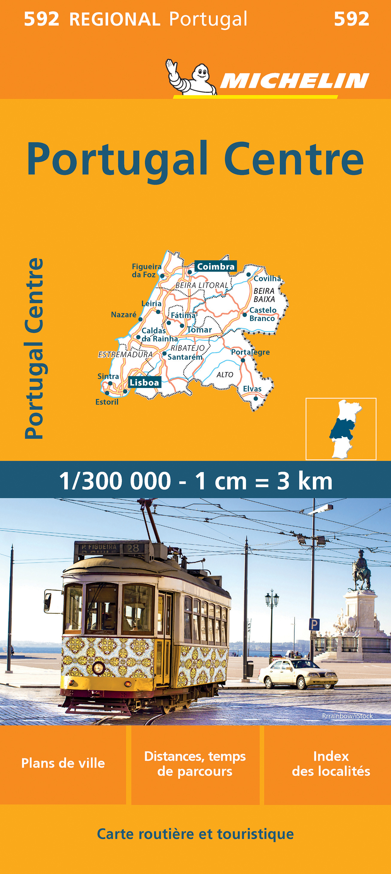
Zoals je van Michelin mag verwachten zijn het onmisbare overzichtskaarten van een uitstekende kwaliteit: een duidelijk en goed leesbaar kaartbeeld. Vrijwel alle berijdbare wegen staan er op ingetekend, in kleur verschillend voor grote en kleine wegen. Andere weginformatie omvat bijvoorbeeld kilometer-afstanden, tolwegen, helling-aanduiding, winterafsluitingen, tankstations maar ook de bekende groene routes: de mooiste wegen om te rijden. Daarnaast geeft de kaart toeristische informatie met symbolen weer: bezienswaardigheden als kastelen, kloosters, musea, maar ook campings (niet allemaal overigens). De kaart is voorzien van een 4-talige legenda. Toch hebben de makers door een beperkt gebruik van symbolen geen drukke kaart gemaakt. De kracht zit hem dan ook in de combinatie van meer dan voldoende informatie en goede leesbaarheid. Part of the orange regional series from Michelin, this Portugal Centre map shows this part of Portugal in excellent detail. Primary & secondary road networks are clearly marked out with indications of the number of lanes, intermediate distances and various possible road obstacles or things you should know including steep hills, height limits, toll barriers, prohibited roads and roads subject to restrictions. The map also includes small insets with street plans of Lisbon, Leiria, Coimra, Castelo Branco, Portalegre and Santarem, showing road names, one way streets and various places of interest (tourist sights, hospitals, parking, railway stations, etc.). Scenic routes on the map are marked out in green and an extensive index of place names is included. The map also features: Administrative boundaries Railways, Airports and Ferry Services Important sights such as castles, ruins, and churches Driving Times and Distance Charts Road Safety Information A legend in multiple languages, including English Coimbra, Lisbonne, Portugal
€11,95
Bekijk product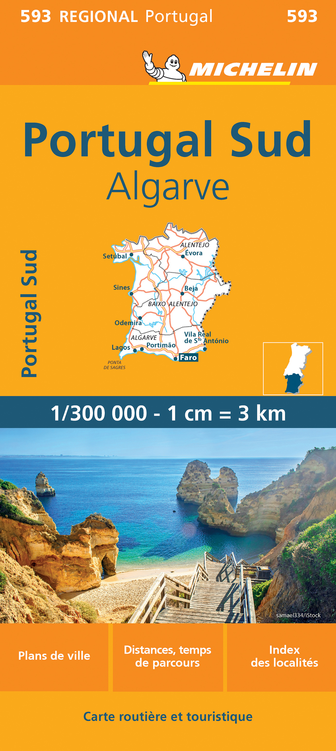
Zoals je van Michelin mag verwachten zijn het onmisbare overzichtskaarten van een uitstekende kwaliteit: een duidelijk en goed leesbaar kaartbeeld. Vrijwel alle berijdbare wegen staan er op ingetekend, in kleur verschillend voor grote en kleine wegen. Andere weginformatie omvat bijvoorbeeld kilometer-afstanden, tolwegen, helling-aanduiding, winterafsluitingen, tankstations maar ook de bekende groene routes: de mooiste wegen om te rijden. Daarnaast geeft de kaart toeristische informatie met symbolen weer: bezienswaardigheden als kastelen, kloosters, musea, maar ook campings (niet allemaal overigens). De kaart is voorzien van een 4-talige legenda. Toch hebben de makers door een beperkt gebruik van symbolen geen drukke kaart gemaakt. De kracht zit hem dan ook in de combinatie van meer dan voldoende informatie en goede leesbaarheid. Part of the orange regional series from Michelin, this Portugal South - Algarve map shows this part of Portugal in excellent detail. Primary & secondary road networks are clearly marked out with indications of the number of lanes, intermediate distances and various possible road obstacles or things you should know including steep hills, height limits, toll barriers, prohibited roads and roads subject to restrictions. The map also includes small insets with street plans of the regions major towns of Lisbon, Setubal, Evora, Beja, Lagos, Portimao and Faro, showing road names, one way streets and various places of interest (tourist sights, hospitals, parking, railway stations, etc.). Scenic routes on the map are marked out in green and an extensive index of place names is included. The map also features: Administrative boundaries Railways, Airports and Ferry Services Important sights such as castles, ruins, and churches Driving Times and Distance Charts Road Safety Information A legend in multiple languages, including English Algarve, Faro, Lisbonne, Portugal
€11,95
Bekijk product
Mooie overzichtskaart van alleen Centraal China met fraai kleurgebruik voor hoogte en reliëf. De kaart is tweetalig en heeft een groot aantal plaatsen, topografisch zonder meer goed. Gebied: centraal en oost China, van Shenyang in het noordoosten tot Chongqing in het zuiden en Yiayuguan in het westen, inclusief de Chinese Muur. Bold altitude colouring, with spot heights and names of mountain ranges and other geographical features, provides an excellent picture of the terrain. The maps show various categories of roads including selected tracks, with intermediate driving distances marked on many routes. Railways, shipping and ferry lines, and local airports are also shown. Province boundaries are indicated and national parks are highlighted. Symbols marks landmarks and features such as tombs, monasteries, churches, temples, ruins, UNESCO sites including the Great Wall, and other places of interest.
€15,95
Bekijk product
Gedetailleerde, tweezijdige landkaart van de Filippijnen, prima geschikt voor planning en rondtrekken over alle eilanden. De berijdbare wegen zijn goed weergeven, zowel de hoofdwegen als provinciale en lokale wegen; wegnummers worden vermeld. Afstanden tussen plaatsen zijn in kilometers op de kaart ingetekend, daarnaast worden ook op belangrijke plekken benzinepompen gemarkeerd. In het kaartbeeld wordt door middel van schaduw het reliëf weergegeven en soms enkele punten in het landschap met de daadwerkelijke hoogte. Provinciegrenzen zijn goed terug te vinden, nationale parken en reservaten ook. Met allerhande symbolen worden toeristische bezienswaardigheden weergegeven als monumenten, historisch belangrijke plekken en uitzichtpunten. In bepaalde plaatsen zijn hotels en campings te vinden, luchthavens, treinverbindingen en havens vindt u er ook op!
€14,95
Bekijk product