
Beantwoord enkele vragen, en binnen seconden geeft AI je een persoonlijk aankoopadvies op maat.
Beantwoord enkele vragen, en binnen seconden geeft AI je een persoonlijk aankoopadvies op maat.
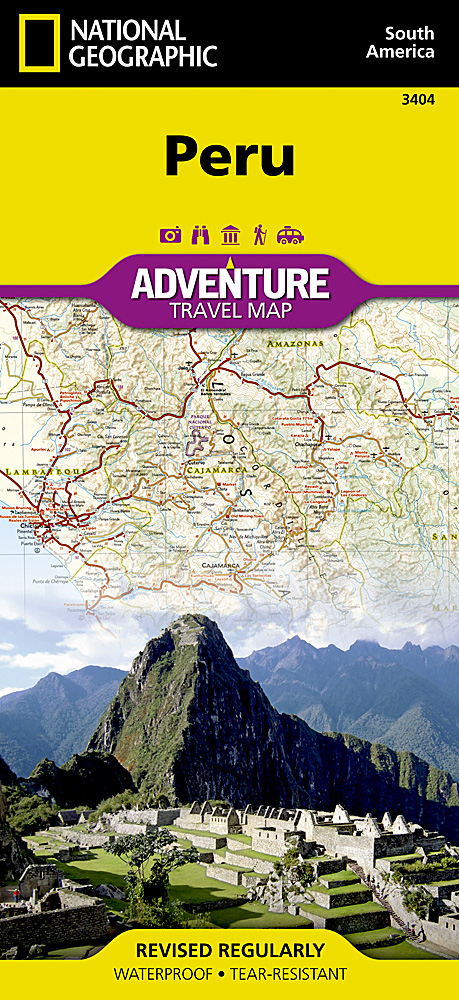
Wegenkaart van Peru met vermelding van veel bezienswaardigheden, nationale parken en attrakties. Watervast en scheurvast. Juist door deze vermeldingen onderscheidt de kaart zich van andere wegenkaarten. National Geographic's Peru Adventure Map is designed to meet the unique needs of adventure travelers—detailed, durable, and accurate. Peru includes the locations of thousands of towns and villages, plus a clearly marked road network complete with distances and designations for highways and roadways. Rough tracks that require four-wheel drive vehicles and paths are included for adventurers seeking to explore more remote regions. What sets National Geographic Adventure Maps apart from traditional road maps are the hundreds of points of interest that highlight the diverse, unique, and exotic destinations within Peru including World Heritage sites, archeological sites, indigenous areas, churches, museums, and more. Users will find a variety of helpful travel aids on our map as well, including the location of airports, airfields, railroads, lighthouses, ferry routes, and harbors. National parks and reserves, beaches, wildlife centers, caves, waterfalls, lodges, scenic viewpoints, and spas are clearly indicated so travelers can take advantage of Peru’s many natural attractions and activities. The front side of the map shows the northern half of Peru including the regions of Loreto, Tumbes, Piura, Amazonas, Lambayeque, Cajamarca, La Libertad, Ancash, Huánuco, and Ucayali. This section of the map spans from Peru’s borders with Ecuador and Colombia on the north and Brazil on the east, down to the coastal city of Chimbote. The regions of Tacna, Puno, Pasco, Moquegua, Madre de Dios, Lima, Junin, Ica, Huancavelica, Cusco, Ayacucho, Arequipa, and Apurímac are included on the reverse side. Provincial and political borders are clearly and accurate marked with colored boundaries, as are the borders of national parks and reserves.
€17,50
Bekijk product
Deze bijzonder gedetailleerde Freytag & Berndt Wegenkaart van Corsica is aan één kant geprint en heeft een schaal van 1:150.000. Op deze kaart staan o.a. fietsroutes, lange afstandswandelpaden, toeristische wegen en bezienwaardigheden aangegeven. In de omslag van de kaart is een apart boekje geniet met een korte beschrijving van de TOP 10 van bezienswaardigheden, een uitgebreide index en plattegrondjes van enkele toeristische plaatsen. Explore the Mediterranean island of Corsica with this Freytag & Berndt single-sided road and leisure map. The best way to plan your trip, prepare your itinerary, and to travel independently on this region. As with all Freytag & Berndt maps, the cartography is clear and detailed with the topography shown with relief shading with plenty of spot heights. This map features a full map of the island. Using Freytag & Berndt's icon system, important tourist information is shown. You will see icons for tourist information such as: Picturesque towns and panoramas Churches, ruins, antique sites and monuments Golf courses, camp sites, and wildlife parks Also included are insets of Corsica's major settlements Ajaccio, Bastia, Corte, Calvi, Porto-Vecchio and Bonifacio. Icons are also used to display information such as public buildings, theatres, casinos, museums, strands and beaches. The legend is in French, German, English, Italian, Dutch, Spanish, Czech, Slovak and Polish. You will also find a helpful booklet featuring the top 10 things to see in Corsica written in German, English, French and Italian; with full colour photographs. An index is also included listing localities along with their postcodes. The top ten are also locatable by icon on the main map.
€14,95
Bekijk product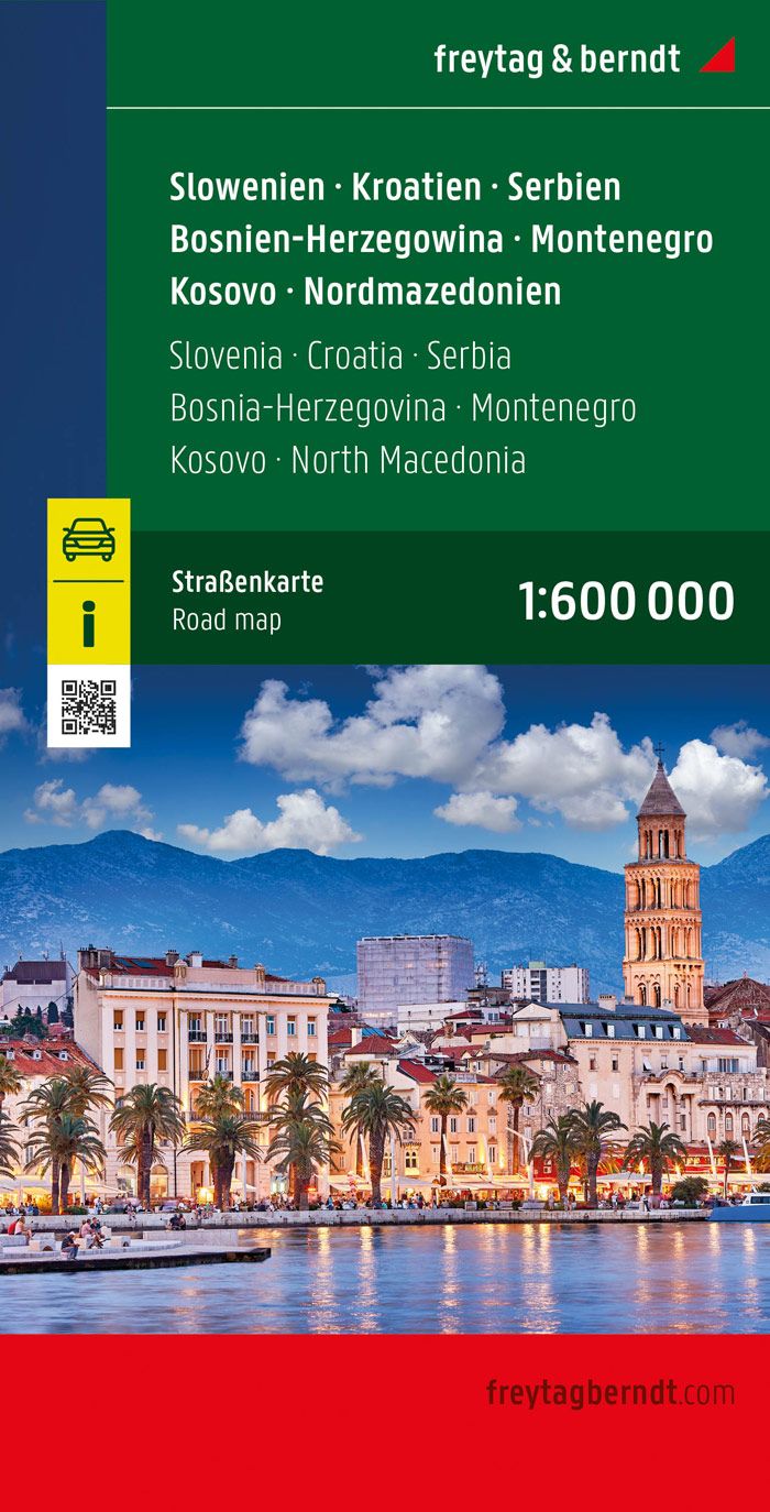
Overzichtskaart van Slovenië, Kroatië, Servië, Bosnië-Hercegovina, Montenegro, Kosovo, en Noord Macedonië. Met uitgebreide index. Deze kaart is tweezijdig met schaal 1:600.000 De berijdbare wegen zijn goed weergeven, zowel de hoofdwegen als provinciale en lokale wegen; wegnummers worden vermeld. Afstanden tussen plaatsen zijn in kilometers op de kaart ingetekend, daarnaast worden ook op belangrijke plekken benzinepompen gemarkeerd. In het kaartbeeld wordt door middel van schaduw het reliëf weergegeven en soms enkele punten in het landschap met de daadwerkelijke hoogte. Provinciegrenzen zijn goed terug te vinden, nationale parken en reservaten ook. Met allerhande symbolen worden toeristische bezienswaardigheden weergegeven als monumenten, historisch belangrijke plekken en uitzichtpunten. In bepaalde plaatsen zijn hotels en campings te vinden, luchthavens, treinverbindingen en havens vindt u er ook op!
€14,95
Bekijk product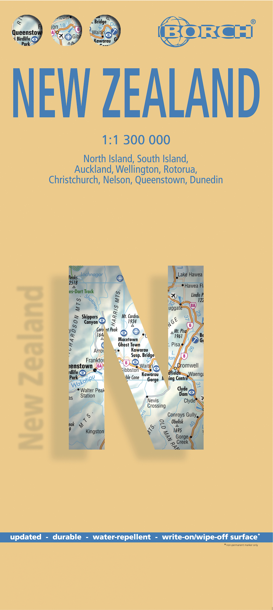
Mooie geplasticieerde kaart van Nieuw - Zeeland. Deze kaart biedt een goed overzicht van het land met detailkaarten. Our soft-laminated map of New Zealand includes: North Island 1:1 300 000, South Island 1:1 300 000, Auckland 1:20 000, Christchurch 1:20 000, Dunedin 1:15 000, Nelson 1:15 000, Rotorua 1:15 000, Queenstown 1:15 000, Wellington 1:20 000, New Zealand administrative & time zones, interesting statistics, conversion chart for temperatures, weights and measures, climate chart with temperatures, sunshine hours, precipitation and humidity and much more. "4 million inhabitants and 60 million sheep" does not do justice to the charm and natural diversity of this beautiful country. Lush meadows and fertile soils are only some of the natural resources with which New Zealand is endowed, the real natural wealth of this island state in the middle of the South Pacific lies in its incredibly diverse landscape: snow-covered mountains, dense forests, lush green lowlands, crystal-clear rivers and lakes, endless beaches and majestic fjords, even rainforests and volcanoes. New Zealanders know what their homeland has to offer: the skiing season lasts all year in the magnificent alps of South Island; climbers and hikers come here to test their strength against nature; anglers hunt for swordfish in the coastal waters or fish for trout in Lake Taupo; there are beautiful camp sites to be found everywhere. New Zealand is paradise for nature and sport lovers, and you can always be sure of a warm welcome from the friendly locals.
€11,50
Bekijk product
Bijzonder goed leesbare kaart van een deel van de Verenigde Staten - USA, in dit geval het gebied van de staten rond de Great Lakes - Grote Meren. Op deze kaart zijn de Nationale Parken goed zichtbaar ingetekend met een heldere achtergrondkleur. Wegnummers, register, afstanden tussen steden en bijvoorbeeld de beroemde groene wegenaanduiding van Michelin ontbreken niet. Met stadsplattegronden (alleen het centrum) van Buffalo/Niagar Falls, Chicago, Cleveland, Detroit, Milwaukee en Toronto. Michelin USA Great Lakes Map 173 (scale: 1:1,267,000)—part of Michelin's brand-new US regional map series with bright green covers—zooms in close for comprehensive coverage of Wisconsin and Michigan, as well as areas of the other states surrounding the Great Lakes (Minnesota, Iowa, Illinois, Indiana, Ohio, Pennsylvania) and southern Ontario in Canada. It contains city maps for easy driving in Buffalo, Chicago, Cleveland, Detroit, Indianapolis, Milwaukee, Minneapolis/St. Paul, Pittsburgh and Toronto. Michelin star-rated sights and a selection of not-to-be-missed annual events and festivals serve as inspiration for future road trips. Outdoor enthusiasts have their choice of national parks for scenery and activities: Cuyahoga Valley, Isle Royale and Voyageurs. The QR code on the front cover offers even more travel information on destinations through Michelin's ViaMichelin website. The map includes a comprehensive index, a distance chart, and a multi-language legend in English and Spanish. Those traveling for business or pleasure, as well as locals traveling farther afield, will appreciate Michelin's high standard of clear and accurate mapping and the additional information on parks, events and points of interest to make the journey more enjoyable. Buffalo, Chicago, Cleveland, Detroit, Etats-Unis, Milwaukee, Toronto
€10,95
Bekijk product
Een degelijke kaart met aanduidingen van o.a. nationale parken, vliegveld, benzinepomp, dirt-roads en kleine plattegrond van hoofdstad. Als overzichtskaart goed te gebruiken. This is the detailed map of Africa emanating from our continental data base and, at an scale better than Michelin's famous regional map, we feel that this version is a winner. First, it is printed double-sided with the western coastal segment on one side and the eastern half on the other. Second, we have been able to improve the accuracy of the road information enormously at the better scale, and third we are making progress in developing a new series of travel maps for Africa by publishing the first of what we hope will become a new regional map covering Africa from top to bottom, or from Cape to Cairo, as Uncle Cecil used to say. The coverage of this map is from Morocco in the west to the Libyan/Egyptian border and from Senegal and Liberia in the southwest to the Chad/Sudan border in the southeast. This is also the first time that we have included any mapping for Guinea, Liberia, or the Ivory Coast on any of our maps, albeit not at a scale that we feel is appropriate yet! Legend Includes: Road by classification, motorways, main roads, secondary road, railway, internationl airports, castles, ruins, waterfall, border crossing, Point of Interests and much more...
€13,95
Bekijk product
Duidelijke wegenkaart van Marco Polo: alle wegen, zowel de verharde als belangrijke onverharde wegen zijn weergegeven. Mooie toeristisch interessante wegen die de moeite waard zijn, zijn groen gearceerd. Veel toeristische informatie is toegevoegd zoals de nationale parken, campings, kastelen en vliegvelden. Afstanden tussen belangrijke steden en benzinestations staan ook op de kaart. Een plaatsnamenregister ontbreekt niet. --- This Marco Polo map features really easy to read cartography. Topography is highlighted with relief shading and loads of spot heights and the road network is clearly shown with roads ranging from motorways all the way through to minor secondary roads. The map also clearly indicates airports, places of interest, scenic/tourist routes, view points etc. The map includes a booklet attached to the cover that contains some useful information and a very extensive index that covers locations, places of interest and geographical features. Also included are a distance/driving time chart and a fold out flap on the cover with an overview map of the region covered. A unique feature of the Marco Polo maps is "mark it" stickers, a set of seven reusable stickers (ie they don't damage the map when removed and placed elsewhere) that can be used to highlight interesting places, the route you plan to take (to make navigation easier), or whatever you want really. The legend is in a multitude of languages including English. --- Die Karten bestechen durch eine leicht lesbare, neue Kartografie, in der durchgängig landschaftlich schöne Strecken und Orte markiert sind. Die Reiseroute gefunden? Mit den in der Umschlagklappe untergebrachten, selbstklebenden mark-it-Stickern lässt sich das angepeilte Ziel hervorheben und somit beim nächsten Blick auf die Karte leicht wiederfinden. Schon in der im Kartendeckel befindlichen, ausklappbaren Übersichtskarte sind die schönsten Orte mit gelben oder grünen Markierungen unterlegt, um unterwegs auch wirklich nichts zu verpassen. Die Distanzenkarte sagt, wie weit es noch ist bis zur nächsten größeren Stadt. Und mit den wichtigsten Cityplänen lässt es sich auch im Großstadtdschungel leicht navigieren. Wo alle Orte auf der Karte zu finden sind, ist im Registerheft nachzuschlagen.
€14,95
Bekijk product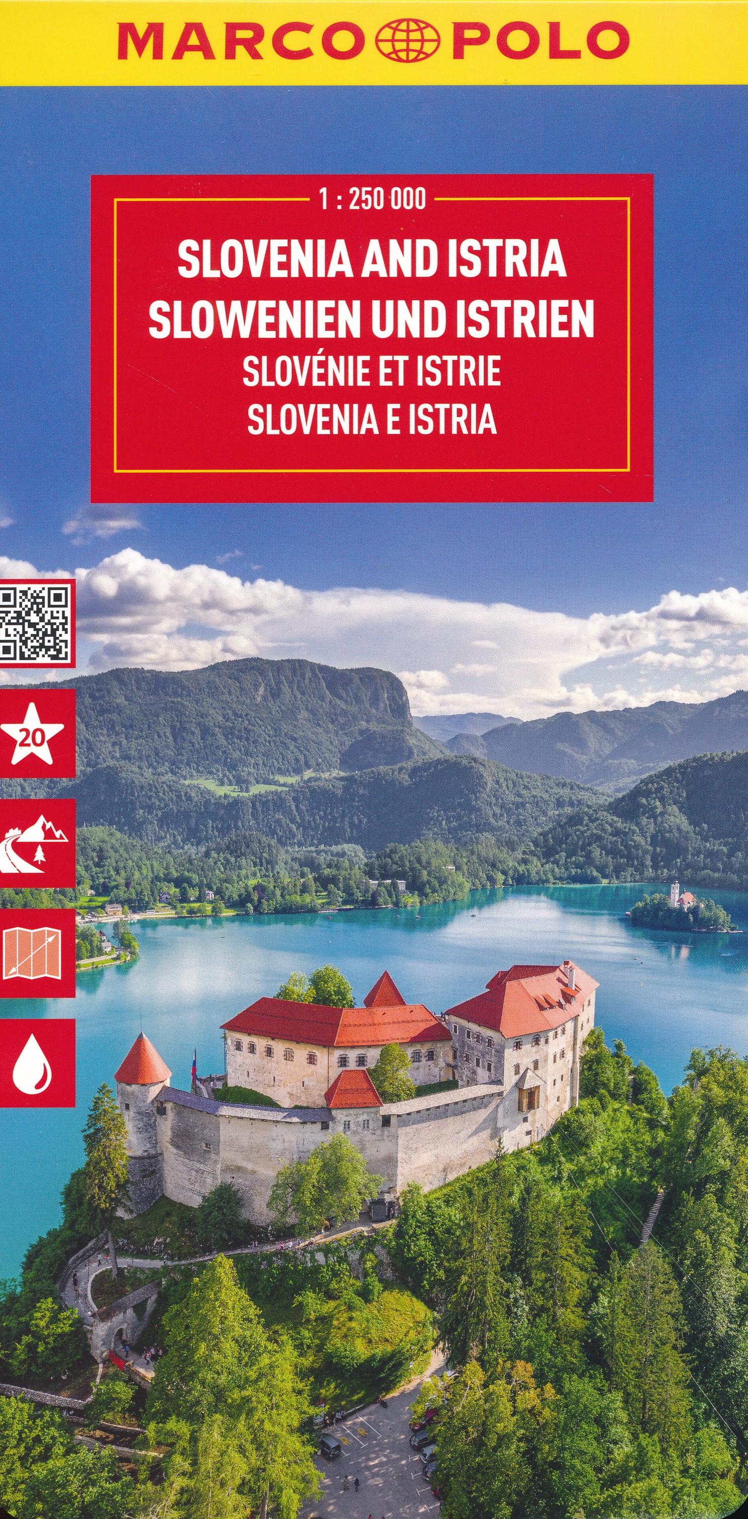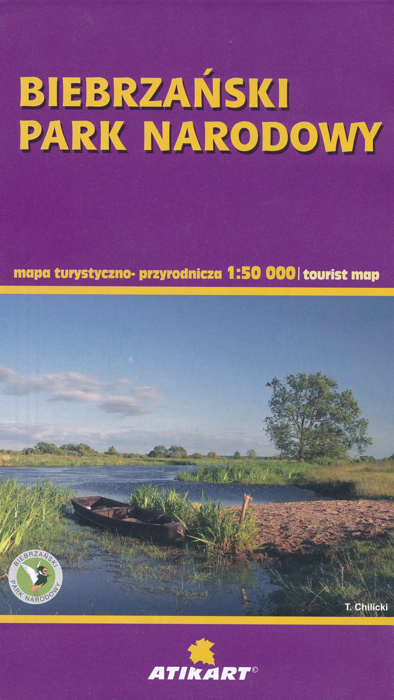
Wandelkaart Biebrza National Park 1:100.000 en 1:50.000 met praktische informatie en wandelideeën. Hiking, cycling, and horse riding paths are highlighted, as well as special educational trails. Along the Biebrza and its tributaries the map shows kayaking routes and marks stretches where fishing is prohibited. Symbols indicate various types of accommodations, including campsites, B&Bs and youth hostels, restaurants and bars, bike and kayak/canoe rentals, nature observation towers, sport and recreational facilities, etc. The map has no geographical coordinates. Map legend includes English. Insets at 1:50,000 show the two main marches in greater detail, plus the areas around the villages of Goniadz and Wizna. Also included is an inset showing the physical geography of the region around the national park. On the reverse, extensive text, in Polish, describes numerous hiking, cycling and water trails, places of interest, etc, including a suggested itinerary for a 7-day visit to the area. Also included are adverts for various local facilities
€9,95
Bekijk product
Duidelijke wegenkaart van Marco Polo: alle wegen, zowel de verharde als belangrijke onverharde wegen zijn weergegeven. Mooie toeristisch interessante wegen die de moeite waard zijn, zijn groen gearceerd. Veel toeristische informatie is toegevoegd zoals de nationale parken, campings, kastelen en vliegvelden. Afstanden tussen belangrijke steden en benzinestations staan ook op de kaart. Een plaatsnamenregister ontbreekt niet. Für die große Fahrt und kleine Abstecher. Die MARCO POLO Länderkarten bestechen durch eine leicht lesbare Kartografie, in der durchgängig landschaftlich schöne Strecken und Orte markiert sind. Schon in der, im Kartendeckel befindlichen, ausklappbaren Übersichtskarte sind die schönsten Orte mit "Marco Polo Highlight-Sternen", sowie gelben oder grünen Markierungen unterlegt, um unterwegs auch wirklich nichts zu verpassen. Die wichtigsten Ballungsraumkarten und Citypläne in den Karten sorgen zusammen mit dem praktischen Zoom-System für die beste Orientierung auch in den Städten.
€14,95
Bekijk product