
Beantwoord enkele vragen, en binnen seconden geeft AI je een persoonlijk aankoopadvies op maat.
Beantwoord enkele vragen, en binnen seconden geeft AI je een persoonlijk aankoopadvies op maat.

Geplastificeerde motorkaart met routes, bezienswaardigheden en overnachtingsmogelijkheden. Die Motorradkarte bietet 7 Touren (146 - 200 km) durch den Pfälzer Wald und den Hunsrück. Dichte Waldgebiete mit Burgen und Schlössern locken mit kurvenreichen Straßen. Abstecher zur Mosel werden empfohlen, auch tolle Aussichtspunkte entlang der Saar. Neben der Tourenbeschreibung finden sich Infos zu Städten wie Trier oder Saarbrücken und kleineren Orten und Bikertreffs. Ausflugstipps und Anzeigen über Gastronomie vor Ort helfen bei der Planung.
€14,95
Bekijk product
Gedetailleerde wegenkaart en wandelkaart met alle kleine wegen, wandelpaden, hoogtelijnen en toeristische informatie aangegeven. Alle tekst is tweetalig in Engels en Grieks en de waterproof kaart is geschikt voor gebruik met GPS. The first highly accurate map of Mt Athos. Created with GPS technology and extensive field survey, this map of Mt. Athos from TERRAIN Editions offers to the visitor a unique wealth of information. If you plan to hike from one monastery to the other, explore the mainland or climb to the top of Mt. Athos, this precise and reliable map will prove invaluable. FEATURES Κaryes town plan in 1:3.000 scale and Κaryes area map in 1:10.000 scale All monasteries, scetes, cells, seats and huts, marked with distinctive symbols and their names All walking trails, with measured distances A concise guide to the monasteries, and general information on Mt. Athos Printed on polyart
€12,50
Bekijk product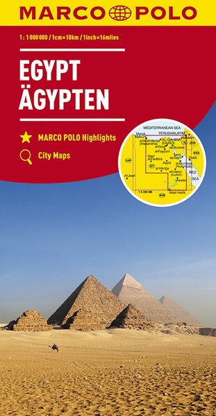
Duidelijke wegenkaart van Marco Polo: alle wegen, zowel de verharde als belangrijke onverharde wegen zijn weergegeven. Mooie toeristisch interessante wegen die de moeite waard zijn, zijn groen gearceerd. Veel toeristische informatie is toegevoegd zoals de nationale parken, campings, kastelen en vliegvelden. Afstanden tussen belangrijke steden en benzinestations staan ook op de kaart. Een plaatsnamenregister ontbreekt niet. This Marco Polo map of Egypt features really easy to read cartography. Topography is highlighted with relief shading and loads of spot heights and the road network is clearly shown with roads ranging from motorways all the way through to minor secondary roads. The map also clearly indicates airports, places of interest, scenic/tourist routes, view points etc. The map includes a booklet attached to the cover that contains some useful information and a very extensive index that covers locations, places of interest and geographical features. Also included are a distance/driving time chart, a fold out flap on the cover with an overview map of the region covered and a reasonably detailed enlargement of Cairo, Thebes and Luxor. A unique feature of the Marco Polo maps is "mark it" stickers, a set of seven reusable stickers (ie they don't damage the map when removed and placed elsewhere) that can be used to highlight interesting places, the route you plan to take (to make navigation easier), or whatever you want really. The legend is in a multitude of languages including English.
€14,95
Bekijk product
Een degelijke kaart met aanduidingen van o.a. nationale parken, vliegveld, benzinepomp en dirt-roads. Als overzichtskaart goed te gebruiken. Double-sided indexed map with street plans of central Ho Chi Min City, Da Lat and Can Tho. The main map at 1:800,000 shows the area’s road and rail networks and local airports. The Ho Chi Minh Trail is highlighted, as are national parks, nature reserves, beaches, numerous places of interest, fuel supplies, etc. Provincial boundaries are marked and names of administrative regions prominently shown. Topography is indicated by altitude colouring. Latitude and longitude lines are drawn at 30’ intervals. On the reverse, the Mekong Delta is shown in greater detail at 1:500,000 with many small waterways. The map also includes street plans of central Ho Chi Minh City, Can Tho and Da Lat, annotated with symbols showing accommodation, various facilities and places of interest. Further insets show Phu Quoc Island at 1:200,000 and, for travelers venturing further north, the environs of Hue at 1:250,000. All place names are shown in the Roman alphabet but with scrupulous transliteration, since the map was prepared by a company with strong Vietnamese connections and a number of local cartographers.
€13,95
Bekijk product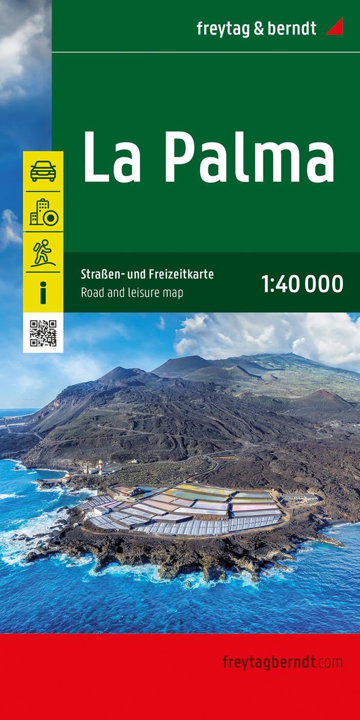
Goede overzichtskaart van La Palma. Juist deze kaart is bij uitstek geschikt voor vele doeleinden. Zowel voor de auto als voor de aktieve vakantieganger goed. Overigens vinden wij dat de Freytag & Berndt kaarten van de Spaanse en Portugese eilanden iets meer gericht zjin op algemeen toerisme en iets minder op wandelen; voor wandelen raden we toch de Kompass - kaarten serie aan die van de meest eilanden ook voor handen is. The La Palma road map on a scale of 1:40,000 contains all the important information for holidaymakers who want to visit La Palma. The extensive road network is precisely represented and many tourist attractions are shown on the map. Drivers and motorcyclists particularly appreciate the precise cartography from freytag & berndt for route planning and on-site orientation. Hikers can also use the map for hiking tours thanks to the detailed scale and contour lines. Information about the La Palma road map Scale 1:40,000 Hiking trails Tourist information Innenstadtpläne: Santa Cruz de La Palma, Los Llanos de Aridane Format: 86 x 124 cm The ideal road map for La Palma drivers, motorcyclists and camping lovers will not only find remote and lesser-known places in this road map, but also scenic routes that are particularly highlighted. Campsites are of course also listed. Printed in Austria.
€14,95
Bekijk product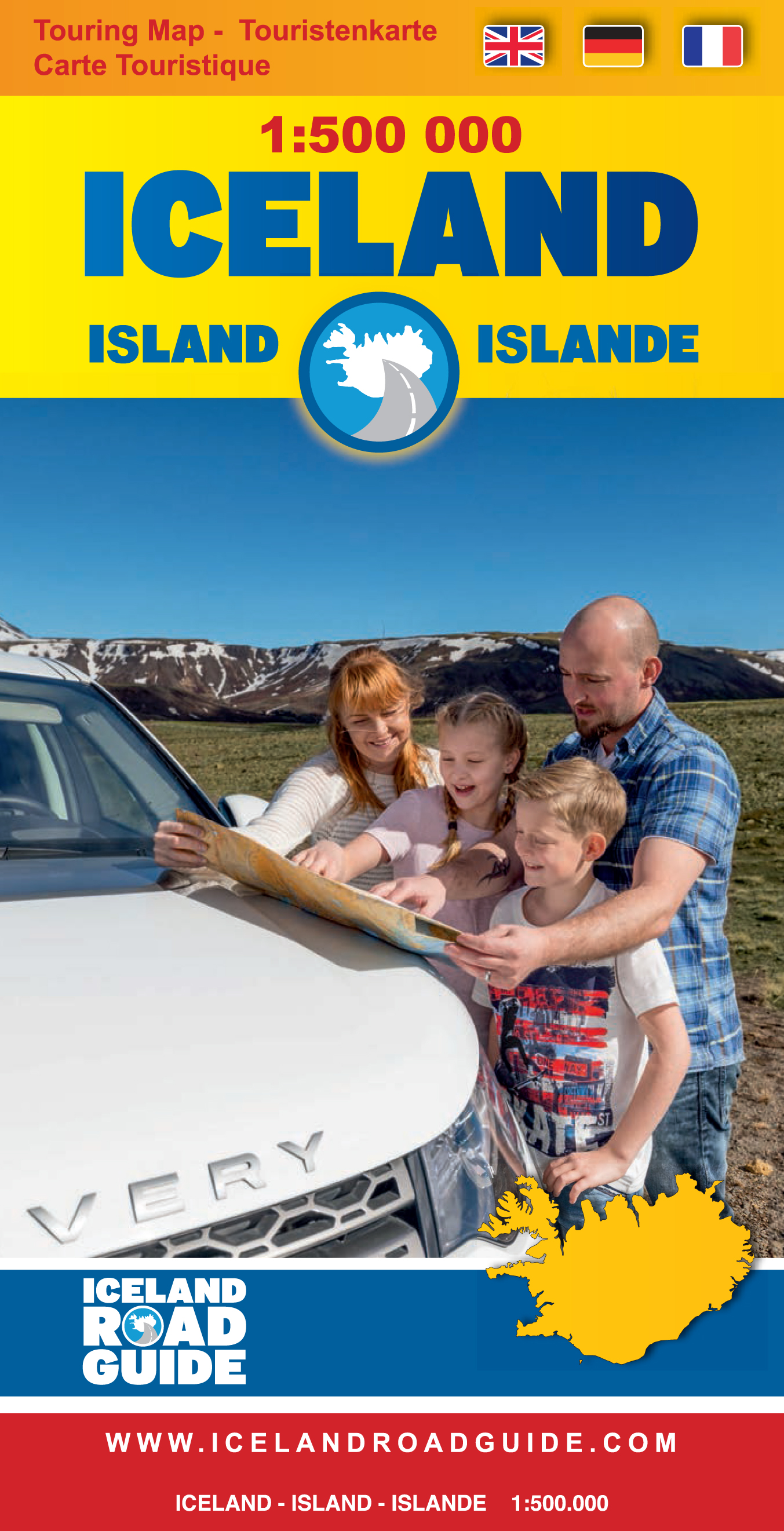
Toeristische kaart van IJsland inclusief handige app. High quality overall map of the country in the scale 1:500 000 with the latest official update about the road system. Some unique features of this map are explanation of lcelandic place names, table of volcano activity, night & daylight scheme for each month, distance table and place name index. How to drive in Iceland. Some facts about Iceland. Information and photos of 34 tourist attractions along with important tourist information such as accommodations, swimming pools, natural baths, museums, golf courses, filling stations etc.
€19,95
Bekijk product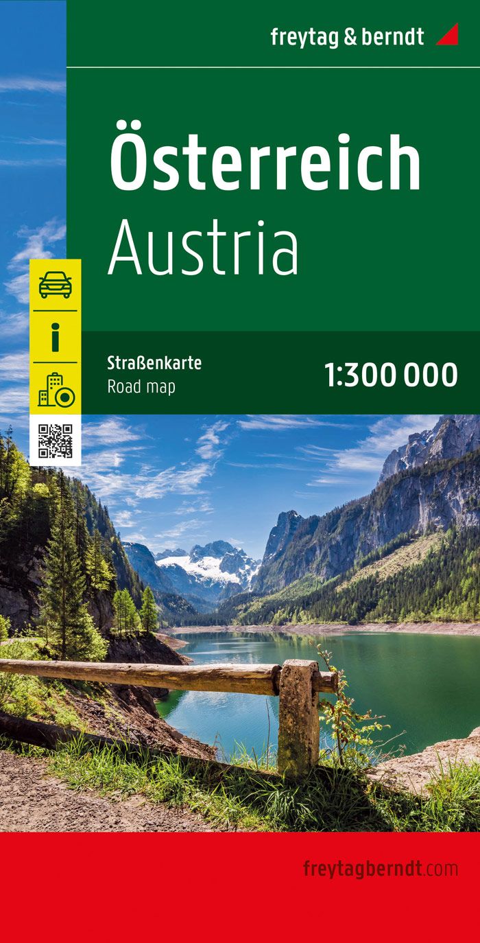
Westfalzung: Die Karte ist so gefaltet, dass beim Öffnen der Westen Österreichs vorne und damit leichter zugänglich ist. Neben der übersichtlichen Gestaltung bietet die "Straßenkarte Österreich 1:300.000" zahlreiche Zusatzinformationen wie z.B. Straßenbeschaffenheit, Sehenswürdigkeiten, Campingplätze und Innenstadtpläne aller Landeshauptstädte. Mit dem umfangreichen Ortsregister gelingt zudem eine rasche Orientierung. Entfernungen in km Ortsregister mit Postleitzahlen Doppelseitig, Westfalzung* Citypläne: Bregenz, Eisenstadt, Graz, Innsbruck, Klagenfurt, Linz, Salzburg, St. Pölten, Wien * Diese Ausgabe wurde so gefaltet, dass beim Aufklappen der Karte die westliche Landeshälfte sichtbar ist. Die östliche Landeshälfte befindet sich auf der Rückseite der Karte. freytag & berndt Autokarten sind für viele Länder und Regionen weltweit erhältlich.
€14,95
Bekijk product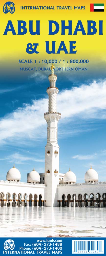
We are pleased to release this brand new ITMB title. Abu Dhabi is one of the leading Emirates that are rapidly becoming vacation heavens for Europeans who don't want the long flights to Asian destinations. The city is so modern it almost squeaks. The palace is a world-class wonder, the seafront Corniche is a marvelous beach, and the central shopping area offers everything from hamburgers to Gucci bags. Motorways now connect the city state to nearby Dubai and to Oman, with a recently-completed one along the coastline to the Saudi border. The reverse side of the map is an updated edition of the entire United Arab Emirates and most of Oman, with new motorways seemingly everywhere. A large inset map of central Dubai is included, along with a good one of Muscat. We docked at Abu Dhabi's cruise ship terminal during our visit and were impressed by the extent of urbanization of the city. Legend Includes: Roads by classification, Rivers and Lakes, National Park, Airports, Points of Interests, Highways, Main Roads, Zoos, Fishing, and much more...
€13,95
Bekijk product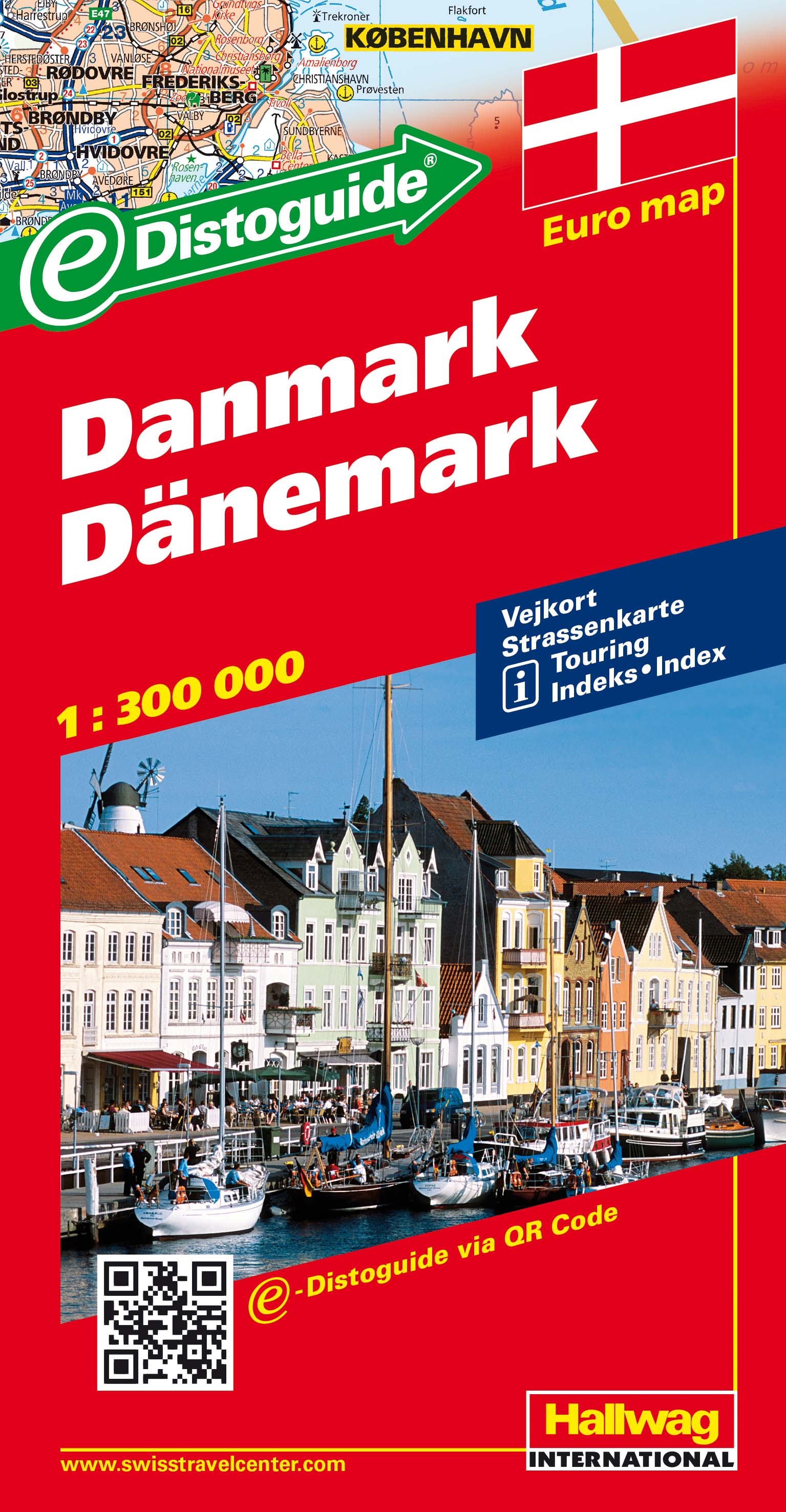
STRASSENKARTEN MIT DISTOGUIDE Aktuelle Information, übersichtliche Darstellung, einfache Handhabung: das Markenzeichen der Hallwag-Strassenkarten. Das internationale Programm mit neuen Ideen für besseres Reisen bietet Ihnen überzeugende Vorteile. Distoguide - der eingebaute «Kilometerzähler» - auf der Aussenseite des Kartendeckels. Für den einfachen und schnellen Zugriff. Sehr praktisch für Planung und Reise! Mit Leichtigkeit lassen sich auf dem im Kartendeckel integrierten Distanzenschieber über 2000 Entfernungen ablesen. Massstab: 1 : 400 000 Detailed touring map of Denmark, also south-western Sweden between Malmo and Gothenburg and extending south to Hamburg and Bremenhaven and covering the whole of the Baltic coast of Germany. The map shows seven different kind of roads, with road names and junction numbers, intermediate driving distances in km, petrol stations, restaurants and motels along main roads. Railways, ferry lines and shipping routes, airports and administrative boundaries are also marked alongside spot elevation in metres, wood, heath and recommended beaches. A number of symbols also indicates places of interests, viewpoints, notable buildings and ruins, monuments and campsites. The map also includes a special "Distoguide" incorporated into the map cover, showing at a glance road distances between several Swedish cities. Map index is in a separate booklet attached to the cover. All texts are in six different European languages including English.
€14,50
Bekijk product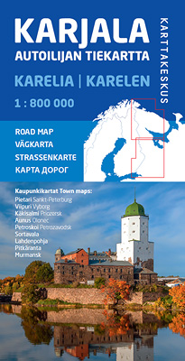
De kaart beslaat de Russische regio Karelië en Moermansk en strekt zich uit van St. Petersburg tot aan de Noordelijke IJszee. In het oosten strekt de kaart zich uit tot de oostelijke kant van Ääninen en het oostelijke deel van het Kola-schiereiland. Op de kaart is ook het gebied nabij de grens aan de Finse kant te zien. De schaal is de bekende 1:800.000 van de wegenkaart van Autoilija (1 cm op de kaart = 8 km op het terrein). De namen op de wegenkaart zijn geschreven in zowel Cyrillische als Latijnse letters, en de oude Finse namen staan er ook op. Naast de duidelijke weg zijn op de kaart bijvoorbeeld grensovergangen, brandstofverkooppunten, bezienswaardigheden en verblijfplaatsen gemarkeerd. De wegenkaart voor automobilisten Karelië heeft ook negen gedetailleerde stadskaarten: St. Petersburg, Vyborg, Sortavala, Käkisalmi, Moermansk, Petroskoi, Pitkäranta, Lahdenpohja en Aunus/Olonets.
€22,95
Bekijk product