
Beantwoord enkele vragen, en binnen seconden geeft AI je een persoonlijk aankoopadvies op maat.
Beantwoord enkele vragen, en binnen seconden geeft AI je een persoonlijk aankoopadvies op maat.
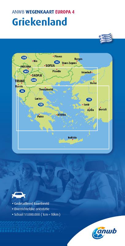
De ANWB heeft een grote serie wegenkaarten van de belangrijkste landen en streken. Het zijn echte overzichtskaarten van vaak een wat groter gebied. Deze keuze zorgt er voor dat de schaal vrij grof is en bepaalde details zijn weggelaten. De kleurstelling is een beetje flets waardoor je niet altijd even makkelijk onderscheid kan maken tussen verschillende landschappen of natuurlijke aspecten. Ook het register ontbreekt. Het grote voordeel is vaak dat het gebied op de kaart overeenkomt met de vraag van klanten. Voor het plannen van een vakantie een prima kaart! Vergeleken met andere uitgevers van kaarten als Michelin, Freytag und Berndt of Reise KnowHow heeft de ANWB duidelijke keuzes gemaakt en gekozen voor een echte overzichtskaart. MET DE ANWB WEGENKAART, WEET JE WAAR JE STAAT! ANWB wegenkaarten zijn een begrip in het land. Dat laten de verkoopcijfers ook zien. Afgelopen decennia zijn meer dan 10 miljoen kaarten over de toonbank gegaan. De wegenkaarten zijn allemaal vernieuwd, met dikker karton voor de omslagen en papier dat minder makkelijk scheurt, zodat ze veelvuldig in- en uitgevouwen kunnen worden. Ze bieden een duidelijker overzicht van het wegennet en zijn nu nog compacter en handzamer.
€12,99
Bekijk product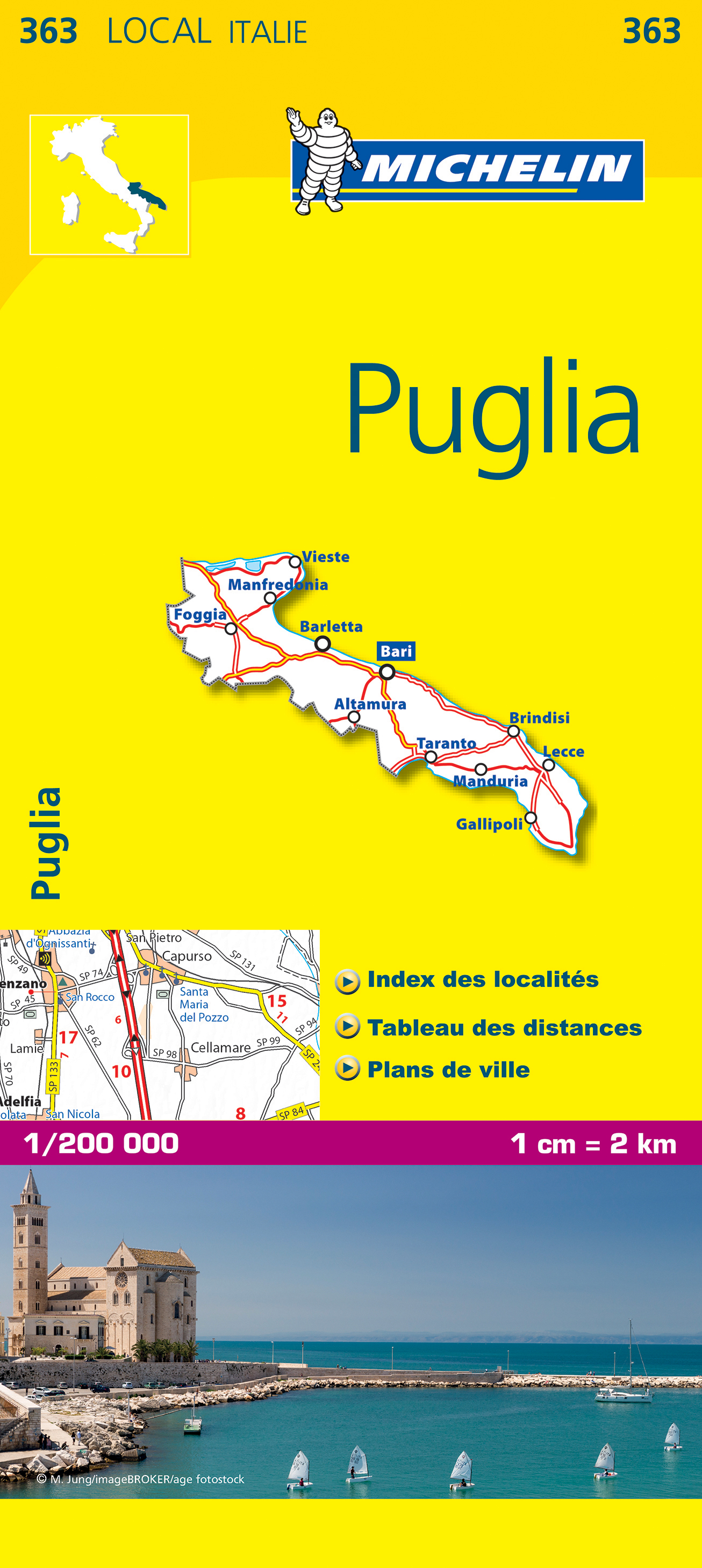
De Michelin kaart is actueel, gedetailleerd, nauwkeurig, praktisch en internationaal. De Lokale Michelin streekkaart biedt u: nauwkeurige en toeristische informatie over een streek of regio, een plaatsnamenregister om uw route gedetailleerd uit te stippelen, een nog waarheidsgetrouwere weergave van de topografie door het satellietbeeld en een selectie van de mooiste plekken. From Michelin's yellow Local series of Europe maps comes this map of Puglia at 1:200 000, showing excellent detail in this region of Italy. The map has the usual excellent road detail characteristic of Michelin maps, with everything from motorways down to rough tracks and footpaths marked out clearly. The number of lanes is indicated on most roads, with intermediate road distances, European route numbers and tolled roads also shown. The map includes highly detailed relief shading that's derived from satellite photos, with plenty of spot heights also. View points, scenic routes, religious and historic buildings, caves, palaces and villas, parks and loads of other places of touristic interest are marked out with symbols. The legend is in a few lanaguages, one of them is English. The map also has a table gving distances and driving times between major towns and citites throughout the region and an extensive index of places. Alberobello, Bari, Foggia, Italie, Lecce, Pouilles, Taranto
€10,95
Bekijk product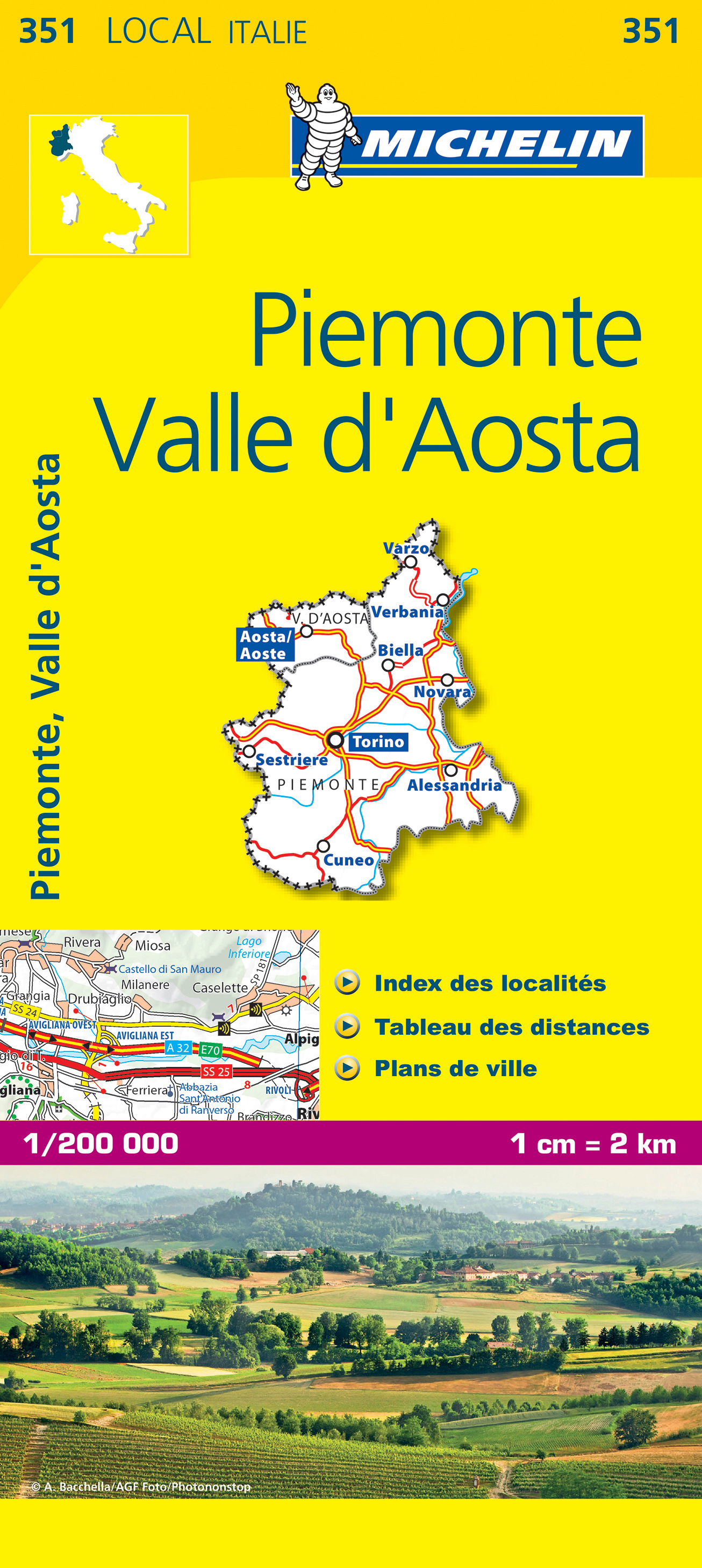
De Michelin kaart is actueel, gedetailleerd, nauwkeurig, praktisch en internationaal. De Lokale Michelin streekkaart biedt u: nauwkeurige en toeristische informatie over een streek of regio, een plaatsnamenregister om uw route gedetailleerd uit te stippelen, een nog waarheidsgetrouwere weergave van de topografie door het satellietbeeld en een selectie van de mooiste plekken. From Michelin's yellow Local series of Europe maps comes this map of Piemonte - Val d'Aosta at 1:200 000, showing excellent detail in this region of Italy. The map has the usual excellent road detail characteristic of Michelin maps, with everything from motorways down to rough tracks and footpaths marked out clearly. The number of lanes is indicated on most roads, with intermediate road distances, European route numbers and tolled roads also shown. The map includes highly detailed relief shading that's derived from satellite photos, with plenty of spot heights also. View points, scenic routes, religious and historic buildings, caves, palaces and villas, parks and loads of other places of touristic interest are marked out with symbols. The legend is in a few lanaguages, one of them is English. The map also has a table gving distances and driving times between major towns and citites throughout the region and an extensive index of places. Alba, Alexandrie, Asti, Italie, Novare, Piémont, Turin, Val d'Aoste
€10,95
Bekijk product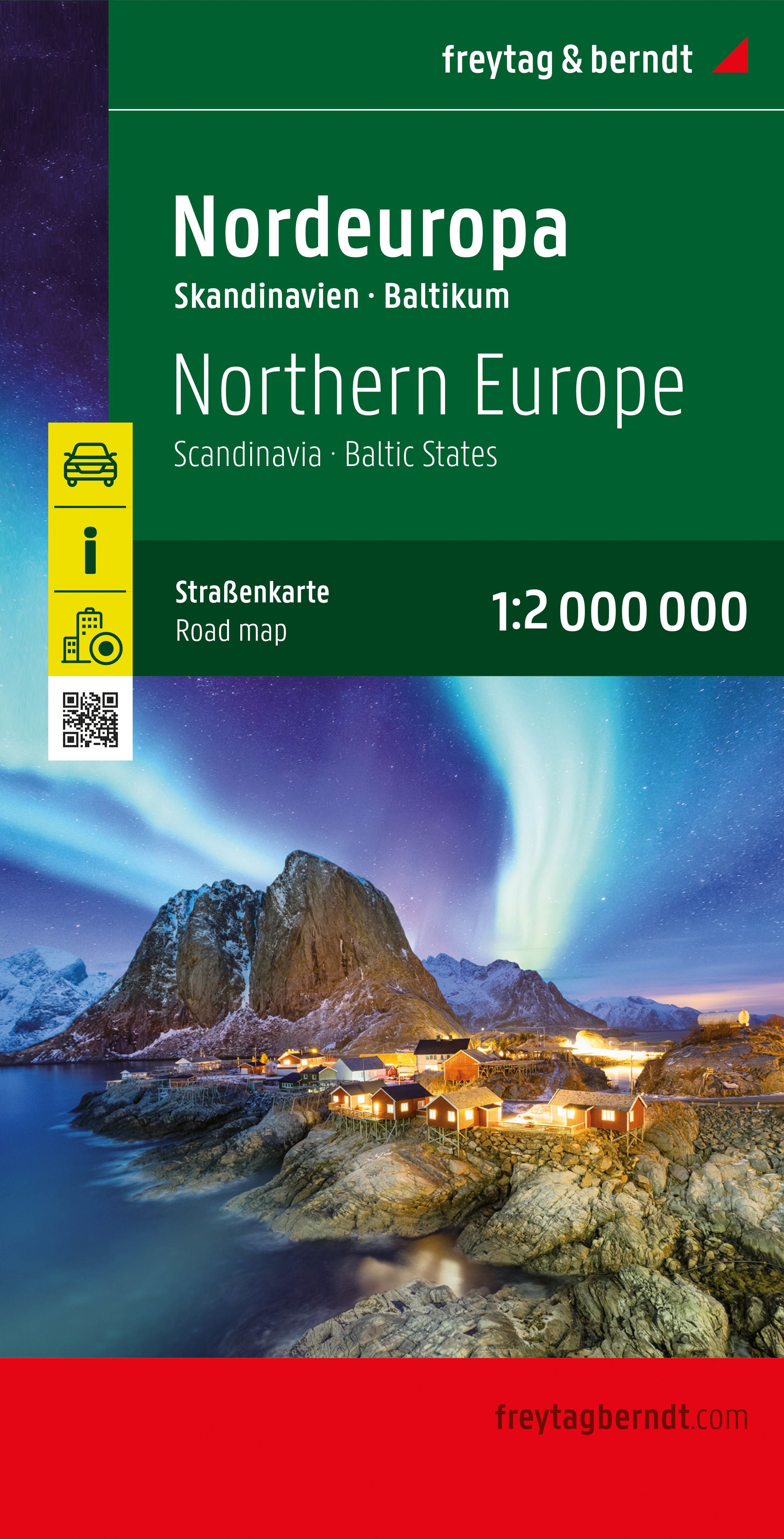
Overzichtskaart van Noord Europa en Scandinavië. Neben der übersichtlichen Gestaltung verfügt die Straßenkarte "Nordeuropa - Skandinavien 1:2.000.000" über Zusatzinformationen wie z.B. Straßenbeschaffenheit und diverse Innenstadtpläne.Mit dem umfangreichen Ortsregister gelingt zudem eine rasche Orientierung. Details: Ortsregister mit Postleitzahlen, Entfernungen in km; Citypläne: Helsinki, Kopgenhagen, Oslo, Reykjavik, Riga, Stockholm, Tallinn, Minsk, Vilnius.freytag & berndt Autokarten sind für viele Länder und Regionen weltweit erhältlich.
€14,95
Bekijk product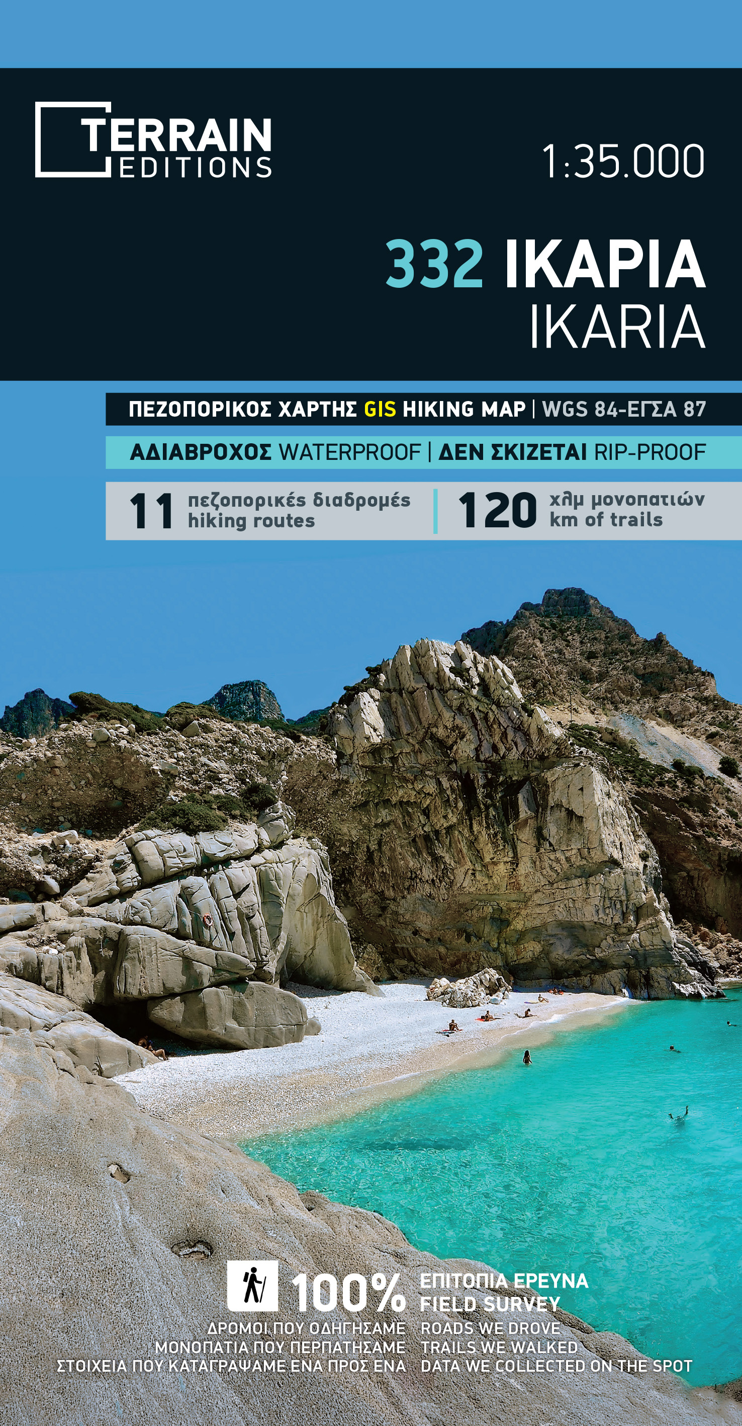
Gedetailleerde wegenkaart en wandelkaart met alle kleine wegen, wandelpaden, hoogtelijnen en toeristische informatie aangegeven. Alle tekst is tweetalig in Engels en Grieks en de waterproof kaart is geschikt voor gebruik met GPS. THIS IS THE BEST MAP OF IKARIA BECAUSE: • It is the only map of Ikaria made with data collected 100% through field survey. • It comes in a more detailed scale than other map in the market. • For the first time, the entire trail network of Ikaria is shown with absolute accuracy. All trails have been measured in kilometers, so you can estimate the duration of your hike. On the back side you ‘ll find detailed descriptions of 11 of the best hikes in Ikaria. These are distinctly labeled on the map, so you can easily locate them. • It features the most complete road network, with scenic routes marked in green. • It is printed on Polyart plastic “paper”, making it totally waterproof and rip-proof. You can fold it and unfold it a hundred times, fold it in irregular ways, dunk it in the sea or leave it out in the rain. This map is indestructible! • The island’s entire coastline is mapped for the first time with TERRAIN’s specially equipped and staffed cartographic vessel. This means that you can locate all beaches of the island, down to the tiniest cove! In fact, the special features of every single beach are recorded: whether it is sandy or pebbled, whether it features natural tree shade, water, a beach bar or organized water sports, whether the seabed in front of the beach is sandy or rocky (so that you will know where to anchor). • It indicates the boundaries of NATURA 2000 areas so that you will know which parts of the island are of special environmental interest and beauty – thus you can enjoy traveling through them, but also take care to protect them. • It features a detailed town plan of Aghios Kirikos, in the scale 1:2.500. • Mountain-bike routes are indicated, for the first time. • The reverse side features an illustrated mini travel guide, with information on the island’s myths and history, geography and natural environment, sights and major attractions.
€12,50
Bekijk product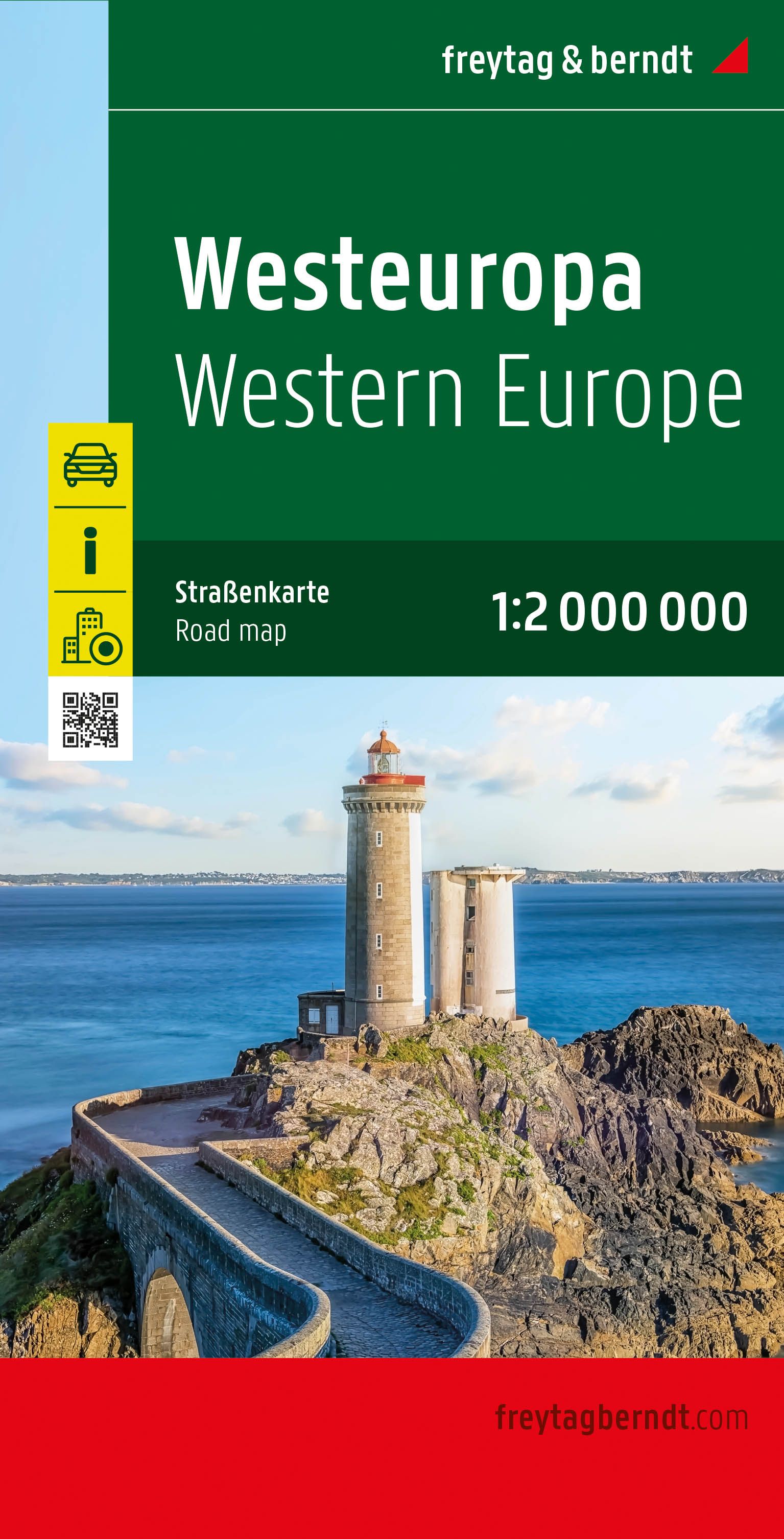
Goede overzichtskaart van West Europa: ideaal om een reis te plannen. High quality road maps with place name index. In many countries these are simply the best maps available. Scales vary according to the size of the country. Index is in several languages. Western Europe at 1:2,000,000 from Freytag & Berndt, with coverage extending from the British Isles to Denmark, the western half of Germany, Switzerland and north-western Italy, with street plans of nine capitals in an index booklet.
€14,95
Bekijk product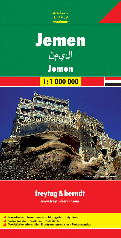
Uitstekende kaart van Jemen. Met index, Nationale parken en afstanden in kilometers. Goed kaartbeeld, register. Wel een vrij grote lap van een kaart, maar prima in detail en geen probleem in de auto / camper. De berijdbare wegen zijn goed weergeven, zowel de hoofdwegen als provinciale en lokale wegen; wegnummers worden vermeld. Afstanden tussen plaatsen zijn in kilometers op de kaart ingetekend, daarnaast worden ook op belangrijke plekken benzinepompen gemarkeerd. In het kaartbeeld wordt door middel van schaduw het reliëf weergegeven en soms enkele punten in het landschap met de daadwerkelijke hoogte. Provinciegrenzen zijn goed terug te vinden, nationale parken en reservaten ook. Met allerhande symbolen worden toeristische bezienswaardigheden weergegeven als monumenten, historisch belangrijke plekken en uitzichtpunten. In bepaalde plaatsen zijn hotels en campings te vinden, luchthavens, treinverbindingen en havens vindt u er ook op!
€14,95
Bekijk product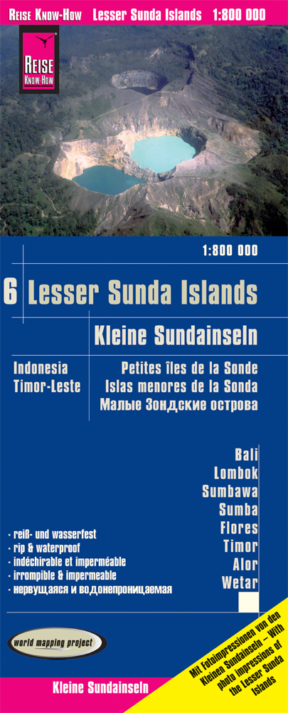
Tweetalige kaart (Engels en Duits). Door ingetekende lengte- en breedtegraden is het gebruik van GPS mogelijk. Met hoogtelijnen. Gedrukt op water- en scheurvast papier! Met de eilanden Bali - Lombok - Sumbawa - Sumba - Flores - Timor - Alor - Wetar Met hoogtelijnen en uitgebreid wegennetwerk: daarnaast worden ook de afstanden tussen belangrijke plaatsen duidelijk leesbaar weergegeven. Het kleurgebruik is zodanig dat je een goede indruk krijgt van hoogteverschillen en soorten landschap. Natuurlijk staan de toeristische bezienswaardigheden duidelijk vermeld. Gedrukt op water- en scheurvast papier! Polyart is een synthetisch product vrij van giftige stoffen dus duurzaam. Het papier gaat echt lang mee. Topography is indicated by altitude colouring with numerous spot heights and names of mountain ranges and passes. Salt lakes, swamps, seasonal rivers and glacier are also shown. Detailed presentation of the road network includes minor roads and tracks and railways are also shown. Internal administrative units are presented with their boundaries and names. National parks and other protected areas are highlighted. A wide range of symbols mark various places of interest. Map legends include English and all the maps have an index of localities.
€11,50
Bekijk product
Scheur- en watervaste wegenkaart van de Peloponnesos.De plaatsnamen op de kaart zijn in het Grieks en het Engels. This is the best map of Peloponnese on the market in every respect. Here’s what makes it so special: Excellent map composition and spatial distribution. The scale of 1:200.00 is extremely demanding in regards to map composition. If you squeeze in too much information you get a user-unfriendly, chaotic map. If you make it too roomy, you get a substandard map unable to satisfy demanding travelers. TERRAIN’s map of Peloponnese is the map with the most ‘practiced’ composition, and the final result is impressive: all roads, villages and sights that a 1:200.00 scale can ‘tolerate’ are so meticulously placed on the map that using it is a piece of cake! G.I.S. mapping technology in two geodetic reference systems (ΕΓΣΑ 87 and WGS 84.) Waterproof Polyart paper, which doesn’t rip. You can fold and unfold your map as many times as you want, in any shape or form, and it’s indestructible. The map of Peloponnese and all other TERRAIN maps are also available as smartphone apps (for all mobile phones with an internet connection.) Download the free app and TERRAIN’s free basic map of Greece from www.viewranger.com, and then download whichever TERRAIN map you are interested in at a greatly reduced price.
€13,50
Bekijk product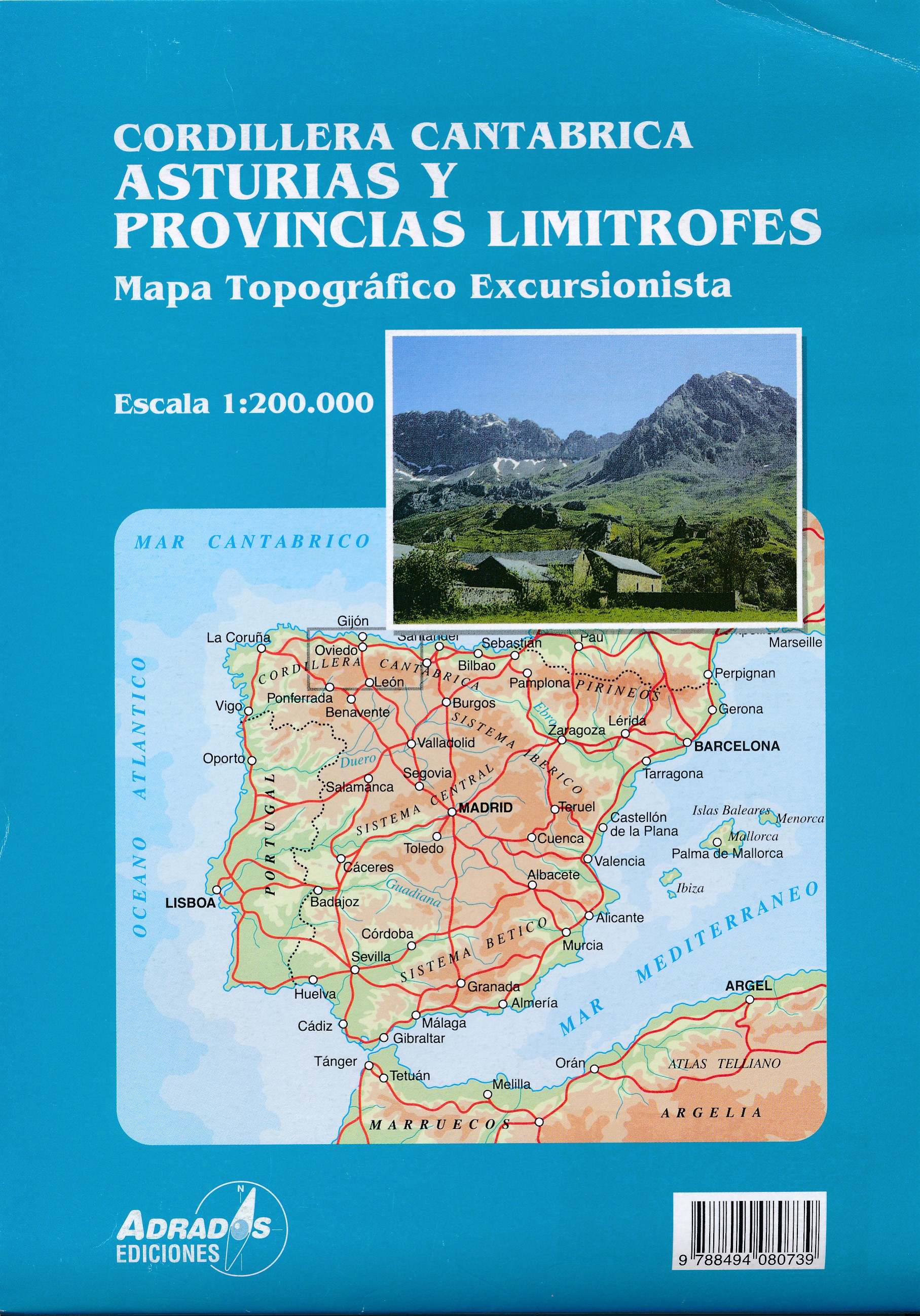
Gedetailleerde wegenkaart an de Cordillera Cantabrica met hoogtelijnen, hoogte verschillen in kleur en schaduw en UTM coördinaten. Met plaatsnamen index! Cordillera Cantabrica on a detailed road map from the Oviedo based Adrados Ediciones, presenting this mountainous region with contours at 100m intervals, altitude coluring, relief shading and UTM coordinates. Since the publishers specialize in detailed hiking maps, including the best coverage of the Picos de Europa, the map includes an exceptionally large number of names of peaks, passes, etc. Symbols highlight best rock and ice climbing areas, huts and refuges, campsites, mountain rescue posts and information centres. Along the coast numerous beaches are named. Road network includes small country roads and tracks. Local railway lines are shown, although not very easy to see on the base map filled with so much information. The map has a 10km UTM grid. Map legend is in Spanish only. On the reverse is a panorama drawing of the area, looking south from the coast with León and Pontevedra in the background. Numerous towns and villages, as well as peaks of the Cordillera Cantabrica are named. An administrative map of the area shows its division into communes and highlights its many protected areas, accompanied by an index listing, where appropriate, each commune with its highest peak. Also included is a very extensive list of all the peaks in the Cordillera Cantabrica over 1200m. Accompanying notes are in Spanish only. Important - please note: All place names are in the local dialect, so Xixon for Gijón, Uvieu for Oviedo, etc. The map is printed on glossy paper and may not withstand repeated folding and unfolding whilst traveling by car, but it is ideal for finding out more about this fascinating region outside its main attraction, the Picos de Europa.
€14,95
Bekijk product