
Beantwoord enkele vragen, en binnen seconden geeft AI je een persoonlijk aankoopadvies op maat.
Beantwoord enkele vragen, en binnen seconden geeft AI je een persoonlijk aankoopadvies op maat.
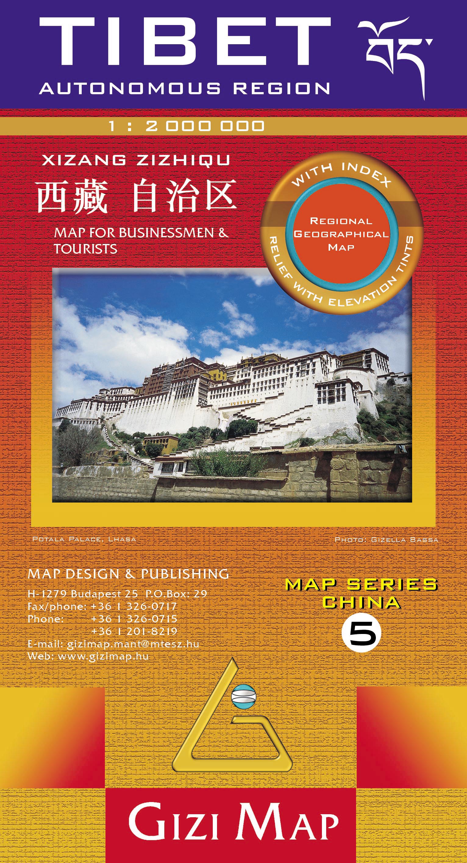
Natuurkundige overzichtskaart Tibet, Bhutan, Nepal met veel plaatsen en wegen, spoorlijnen en rivieren, hoogten, lengte- en breedtegraden - zeer gedetailleerd schaal. Deze kaart is meer gericht op geografische details, minder op het wegennetwerk, daar is van dezelfde uitgever de Roadmpa versie meer geschikt. Tibet in a series of indexed regional maps of China from Gizi Map, in a road edition with relief shading which makes all the place names stand out better against a lighter background. The map provides an alternative to the altitude colouring used in the geographical edition of this title which follows the presentation used for other regions of China. Most place names are also shown in local versions, with the Tibetan language included in the multilingual legend. The maps extend south to include the whole of Nepal and Bhutan. In the remaining part of this series, including the geographical edition of Tibet, bold altitude colouring with spot heights plus names of mountain ranges and other geographical features provides an excellent picture of the terrain. The maps show various categories of roads including selected tracks, with intermediate driving distances marked on many routes. Railways, shipping and ferry lines, and local airports are also shown. Province boundaries are indicated and national parks are highlighted. Symbols marks landmarks and features such as tombs, monasteries, churches, temples, ruins, UNESCO sites including the Great Wall, and other places of interest. Names of main towns are also given in Chinese script and within Tibet alternative versions are provided
€15,95
Bekijk product
Goede betrouwbare kaart van het noordwesten van Namibië: Damaraland en Kaokoland. Met GPS coordinaten. Engels Colour folding Map, 52x73 cm, scale 1:620.000. The first scale road map of this area to be produced with GPS co-ordinates. 100 GPS Co-ordinates of major intersections, refuelling points and accommodation information. Map range 11°45’ to 15°00’ East and 17° to 20°00’ South. Detailed road map Kaokoland / Kaokoveld (Namibia) includes GPS co-ordinates of major intersections, refuelling points and accomodation information. This map covers North-Western Namibia on the one side and BUSHMANLAND and CAPRIVI in North-Eastern Namibia on the reverse side. This map is very much recommended for travelers to these regions as an addition to our bigger scaled Namibia map. Here you get a nice amplified look at the regions with loads of GPS coordinates, accommodation and petrol points. Furthermore we included extensive route and travel ideas and general information on Kaokoland. Sold in a plastic pouch. This picture of the map shows Kaokoland in North West Namibia at a scale of 1:620 000. The reverse side of the map features Bushmanland and Caprivi in North-Eastern Namibia at a scale of 1: 470 000.
€15,95
Bekijk product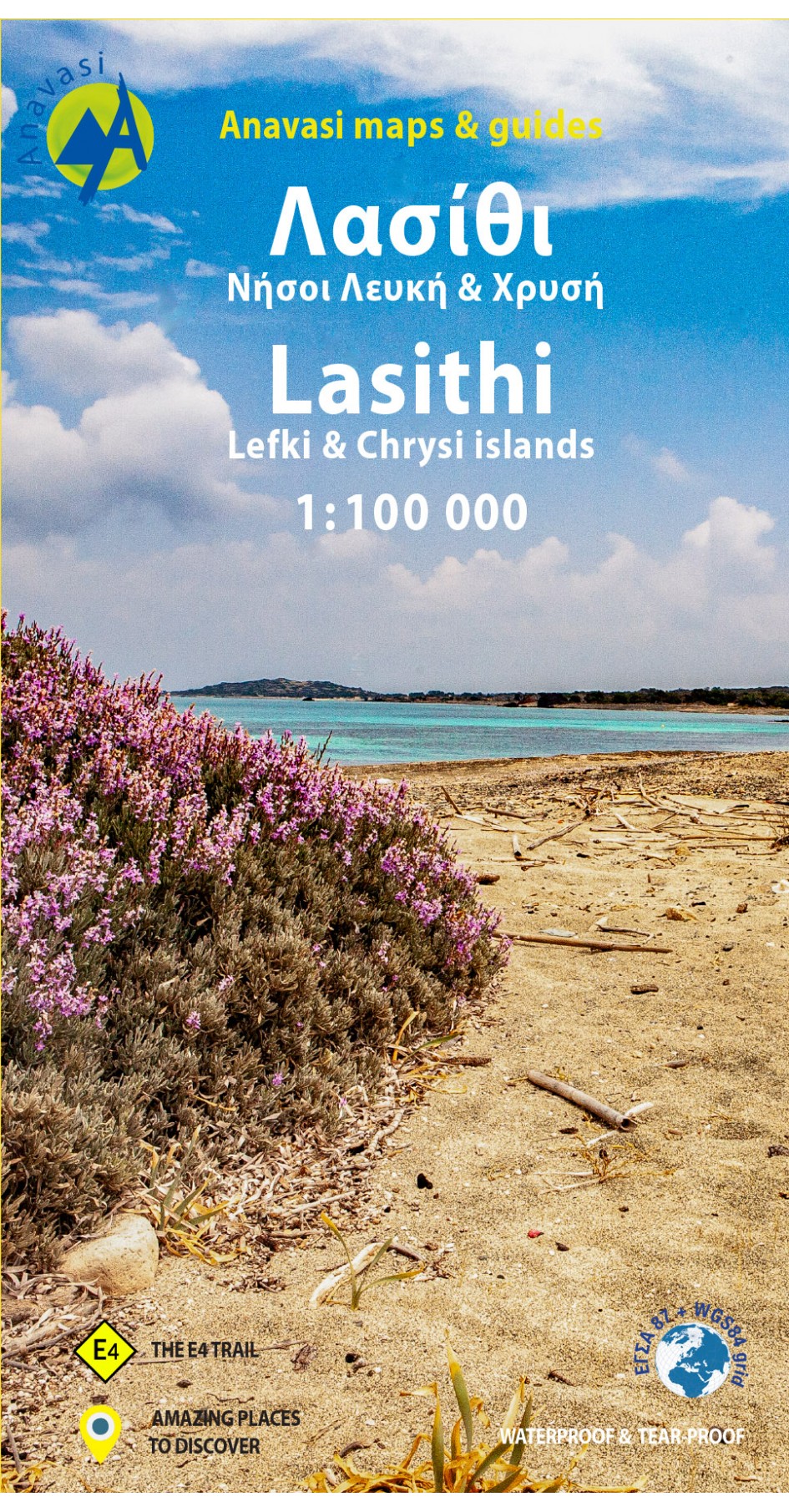
Gebaseerd op topografische kaarten, GPS compatible, gedrukt op watervast en scheurvast papier. Hoogtelijnen met 100 m interval, schaduwkleuren en punten met hoogte geven de topografie van het landschap aan. De kaart kent een UTM grid. Het wegennet wordt aangeduid met verschillende gradaties: grote en kleine wegen, verhard en onverhard. Toeristische bezienswaardigheden staan als zodanig aangeduid zoals thermen, kloosters, berghutten, grotten etc. Namen van steden zowel in het normale schrift als in het Grieks, met een legenda die ook in het Engels is. Van de uitgever This map includes all the information a traveler needs to discover Eastern Crete. It includes the entire road network from the biggest arteries to the smallest dirt roads, paths and trails, all the towns and villages, beaches and toponyms. In addition to the above, you will find the E4 route from Dikti to Zakros that crosses the entire inland of Eastern Crete. On the reverse side you will find sections of the E4 route with elevation profiles as well as an index of settlements so you can easily locate them on the map. It also contains a city plan of Aghios Nikolaos, the capital of Lasithi. Printed on waterproof & tear resistant polyart paper.
€11,95
Bekijk product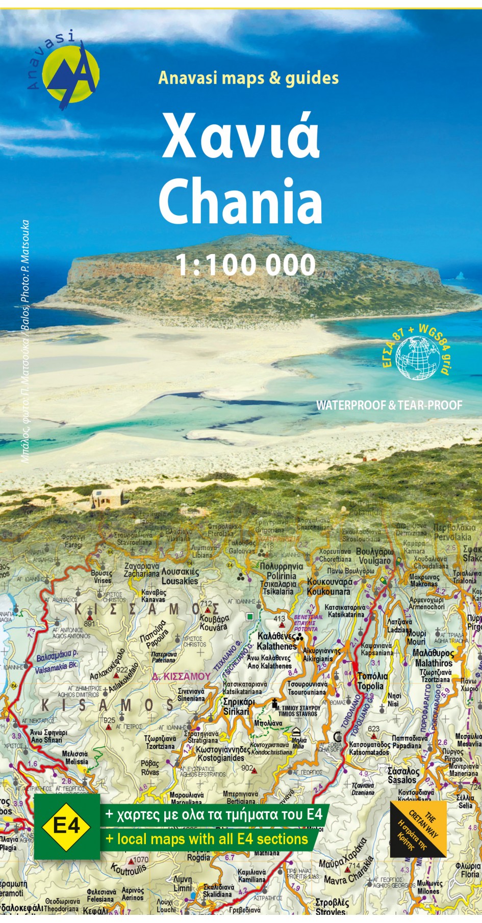
Gebaseerd op topografische kaarten, GPS compatible, gedrukt op watervast en scheurvast papier. Hoogtelijnen met 100 m interval, schaduwkleuren en punten met hoogte geven de topografie van het landschap aan. De kaart kent een UTM grid. Het wegennet wordt aangeduid met verschillende gradaties: grote en kleine wegen, verhard en onverhard. Toeristische bezienswaardigheden staan als zodanig aangeduid zoals thermen, kloosters, berghutten, grotten etc. Namen van steden zowel in het normale schrift als in het Grieks, met een legenda die ook in het Engels is.
€11,95
Bekijk product
Gebaseerd op topografische kaarten, GPS compatible, gedrukt op watervast en scheurvast papier. Hoogtelijnen met 100 m interval, schaduwkleuren en punten met hoogte geven de topografie van het landschap aan. De kaart kent een UTM grid. Het wegennet wordt aangeduid met verschillende gradaties: grote en kleine wegen, verhard en onverhard. Toeristische bezienswaardigheden staan als zodanig aangeduid zoals thermen, kloosters, berghutten, grotten etc. Namen van steden zowel in het normale schrift als in het Grieks, met een legenda die ook in het Engels is. One of the three maps of the successful series of touring maps of Crete in a scale of 1:100,000 maps covering the whole island with great detail. Small additions and updating of road network, the new municipalities and some visual touches (palette relief and cover). On the reverse side of the map fully indexed settlements and cardboard folnter presentation of 10 Top points of interest on the map.
€11,95
Bekijk product
Ideale kaart voor fietsen en autotochten vanuit een vaste plaats als een camping of huisje. Zelfs de kleinste wegen staan ingetekend en geven met symbolen toeristische informatie. De belangrijkste doorgaande GR's staan ook ingetekend. Ook is deze kaart voor wandelaars nog behoorlijk goed bruikbaar: veel details, hoogtelijnen en allerlei andere landschapskenmerken. Berghutten en gites d'etappes zijn weergeven, helaas staan er dan wel weer geen campings op. Al jaren is deze kaartenserie een van de meest verkochte van Frankrijk. Gebied: Châtellerault, Poitiers, Le Blanc, Montmorillon, Lezay, La Souterraine Over fietskaarten: Voor Frankrijk bestaan geen speciale fietskaarten. Dit heeft natuurlijk te maken met het feit dat er nauwelijks uitgezette en gemarkeerde fietsroutes zijn. Toch is de 1:100.000 van IGN ideaal voor het maken van fietstochten: vele details, goede leesbaarheid, correcte wegnummering, hoogtelijnen en een redelijk groot gebied. We raden dan ook altijd juist deze kaarten aan voor fietsen in Frankrijk. Een minpunt is de afwezigheid van campings op de kaart, maar dat is een manco voor elke Franse kaart: op de Michelin kaarten staat slechts een kleine selectie van de meer dan 10.000 campings weergegeven (voornamelijk de Camping Municipal)....een campinggids meenemen is dan ook geen overbodige luxe als je met de tent gaat. Al met al de beste keuze als het gaat om een fietskaart voor Frankrijk en zeker geen slechte!
€10,95
Bekijk product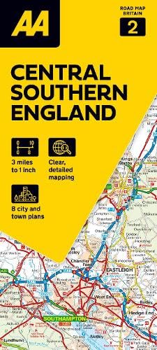
Goede dubbelzijdige Wegenkaart met plaatsnamenindex van het centrale deel van het zuiden van Engeland. Grof geschetst is het een rechthoek tussen Gloucester, Luton, London, Dorcester en Brighton. Britain’s clearest mapping from the experts at the AA, in a handy foldable map. Fully updated, this map of Central Southern England combines clear design and an easy-to-read scale with more road detail to ensure that you never lose your way. The map includes information on toll points, service areas, road numbers, motorways, dual carriageways and wide and narrow local roads. National Parks, and places of interest are also highlighted. Caravan and camping sites pinpointed on the mapping. City and town plans Easy-to-read place index name. Part of a range of 9 regional sheet maps plus 1 map covering the whole of Britain. Map Series - 1 West Country & Wales. 2 Central Southern England. 3 South East England. 4 East Anglia. 5 Midlands & Central England. 6 Wales. 7 Northern England. 8 North England & Scottish Borders. 9 Scotland. 10 Britain.
€10,95
Bekijk product
Goede wegenkaart waarbij naast de gebruikelijke zaken als wegen en plaatsen ook veel aandacht is voor de natuurkundige aspecten van het land. Door het kleurgebruik wordt goed duidelijk waar bos, oerwoud, rivieren, meren liggen. Hoogtes zijn zichtbaar door gebruik van verschillende kleuren. Vaak is op de kaart nog een kleine plattegrond van het centrum van de belangrijkste stad te vinden. 1:12,500/1:2,200,000 Brasil is a huge country of growing economic importance, and of great touristic importance. Sao Paulo is one of the two ‘great cities’ of South America, and deserves to be better mapped than has been the case in the past. This new map updates all of our information on this vibrant city and now adds a new map on the reverse side covering all of densely-populated Southern Brasil, to Belo Horizonte in the north, and Rio Grande in the far south. For good measure, we have included a large inset of central Rio on the map. Printed on paper, double-sided.
€13,95
Bekijk product
Speciale toeristische kaart, gemaakt voor een goed bezocht gebied en uitvergroot. Daardoor zeer prettig leesbaar met een hoog nivo wat we van Michelin al veel langer gewend zijn. Alle wegen staan er op, met verschillende kleuren voor de aparte soorten wegen. Verder veel aandacht met symbolen voor de bezienswaardigheden in de regio, de bekende groene stroken naast de mooie wegen en ingetekende doorgaande wandelroutes als grande randonnees. Alpes-de-Haute-Provence, Draguignan, Fréjus, Manosque, Marseille, Parc naturel régional du Verdon, Provence-Alpes-Côte d'Azur, Saint-Tropez, Toulon, Var
€10,95
Bekijk product
Topografische kaart van een deel van België op een schaal van 1:100.000. Je kunt er door de vele details nog redelijk op wandelen, al zal een meer gedetailleerde schaal beter zijn. Voor fietsen prima door de aanwezigheid van bijvoorbeeld hoogtelijnen. Voorzien van alle topografische details als hoogtelijnen, waterlopen, bosgebieden, paden en brandgangen. Hoogtelijnen maken het mogelijk de moeilijkheidsgraad van een wandeling in te schatten. Belangrijke oriëntatiepunten, zoals solitaire bomen, kapelletjes, hoogspanningslijnen, en vele andere, zijn ingetekend. De kaarten zijn voorzien van een gradenoverzicht en UTM grid en daardoor dus te gebruiken voor GPS tochten.
€8,50
Bekijk product