
Beantwoord enkele vragen, en binnen seconden geeft AI je een persoonlijk aankoopadvies op maat.
Beantwoord enkele vragen, en binnen seconden geeft AI je een persoonlijk aankoopadvies op maat.

Zoals je van Michelin mag verwachten is deze kaart zeer overzichtelijk en heeft een duidelijk helder kaartbeeld. De kaart geeft uitgebreid toeristische informatie weer. Met register, afstanden en reistijden. Wegen worden naar verschillende klasse ingedeeld en - mooi van Michelin - de interessante mooie routes worden gemarkeerd met een groene streep. Hindernissen voor automobilsiten met caravans zijn gemarkeerd: steile hellingen, bergpassen of een anderzins moeilijke route. Bezienswaardigheden als een kasteel, religieus gebouw, ruine of grot is door een symbool goed te vinden. The Michelin National road map of Finland at 1:1,250,000 scale is ideal for route planning. The map gives comprehensive coverage of national road networks showing all major motorways, dual carriageways, national & regional main roads and some single-lane roads. Also shows unsurfaced roads. The map is divided by grid showing latitude and longitude. Distances between major locations are marked along roads, with total distance and several intermediate distances shown. A quick-reference chart of distances & driving times between major locations is also included. The map also includes a grid-referenced index of principal place names. Clear, easy-to read cartography shows roads in reds, yellows and white with black outlines. Major topography is indicated with relief shading. Woodland & forest is marked with green shading. Built-up urban areas are clearly marked in yellow. Airports, ferries, railways, bridges are also marked. National and administrative divisions are marked, as are areas of tourist interest such as rock carvings, national parks and scenic routes. Also includes a quick reference panel giving national driving regulations, including speed limits, equipment requirements (e.g. bulb kits, warning triangles) and seatbelt rules for all countries principally shown. Town plans & regional enlargements: - Helsinki at 1:250,000 scale Finlande
€11,95
Bekijk product
Overzichtelijke wegenkaart van heel Grieklenland. Tweezijdig, gedrukt op waterafstotend en scheurvast papier. Met wegnummerng, mooie route-aanduiding, stranden, afstanden tussen steden en dorpen. Daarnaast ook tweetalig uitgevoerd. Detailed and updated map of Greece using G.I.S. (Geographical Information Systems) technology and the WGS84 reference system, and supplemented by a ΕΓΣΑ87 grid. Like all of TERRAIN’s large maps, the map of Greece is printed on Polyart, which is extremely durable against folding and unfolding, does not rip, and is 100% waterproof. Based on field research completed in 2013, this map features all the newest national motorways and their interchanges, toll stations and Motorway Service Stations. Also depicted are Greece’s most important sights, as well as archaeological sites, castles, monasteries, National Parks and scenic routes worth exploring. The map comes in a very practical clear double sleeve. One side contains the removable map, the other a removable booklet with the alphabetical index of cities, villages, archaeological sites and monasteries.
€13,50
Bekijk product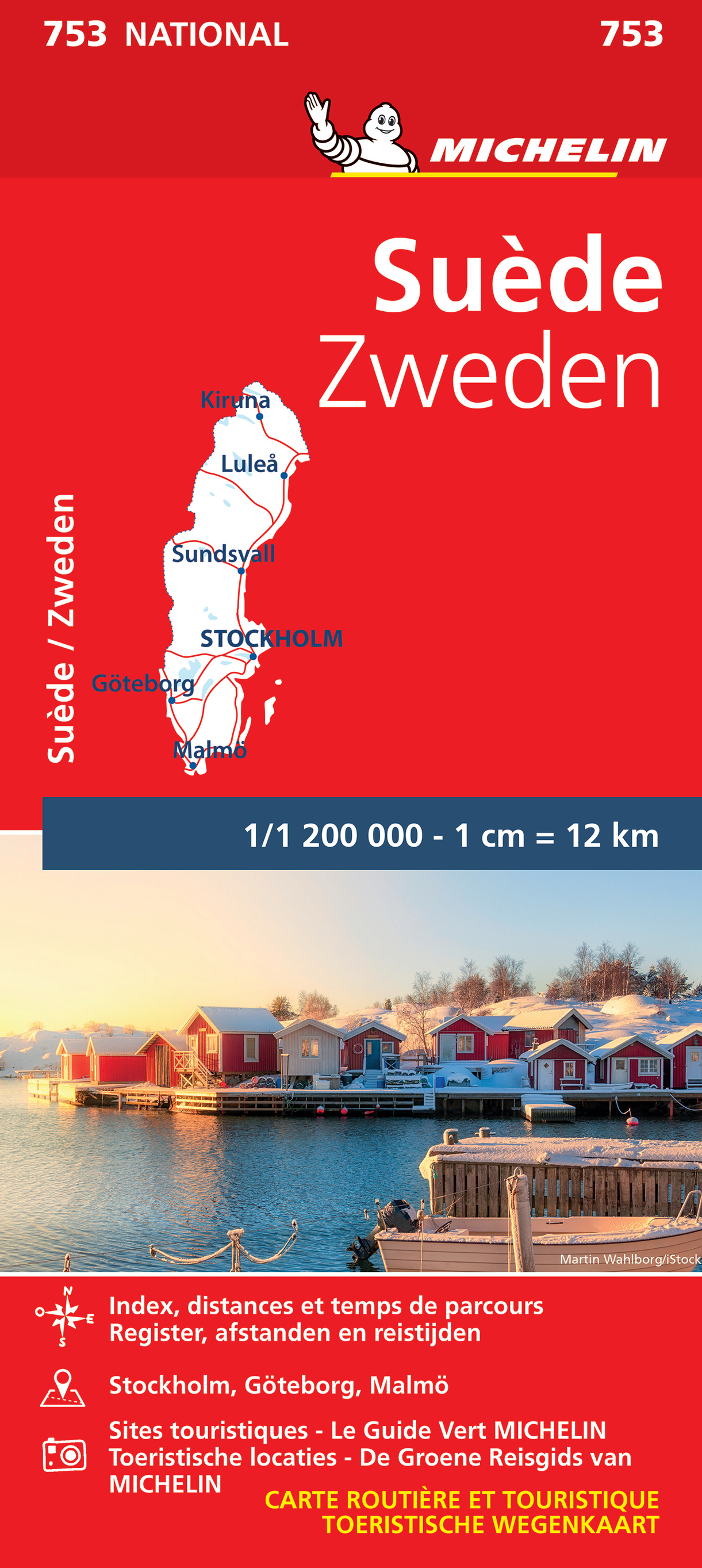
Zoals je van Michelin mag verwachten is deze kaart zeer overzichtelijk en heeft een duidelijk helder kaartbeeld. De kaart geeft uitgebreid toeristische informatie weer. Met register, afstanden en reistijden. Wegen worden naar verschillende klasse ingedeeld en - mooi van Michelin - de interessante mooie routes worden gemarkeerd met een groene streep. Hindernissen voor automobilsiten met caravans zijn gemarkeerd: steile hellingen, bergpassen of een anderzins moeilijke route. Bezienswaardigheden als een kasteel, religieus gebouw, ruine of grot is door een symbool goed te vinden. Suéde
€11,95
Bekijk product
Een degelijke kaart met aanduidingen van o.a. nationale parken, vliegveld, benzinepomp, dirt-roads en kleine plattegrond van hoofdstad. Als overzichtskaart goed te gebruiken. At last! This is the 'new' artwork covering northern Borneo in detail. We used to have two maps for this area, but have combined the artwork into one double-sided map covering the same area as formerly, but as one map, and with greater consistency in colouring and style. The base artwork has been updated and readability improved. This is a 'new' map, in that ITMB has never had a title exactly like this, but it is an 'update' in that we have had this artwork available before, which justifies the 2nd Edition label. Legend Includes: Motorway, Major Highway,Airport,Car Ferry route and many more
€13,95
Bekijk product
Een degelijke wegenkaart met aanduidingen van o.a. nationale parken, vliegveld, benzinepomp, dirt-roads. Als overzichtskaart goed te gebruiken. Thanks to satellite imagery, we are now able to re-introduce a completely new map of this popular travel destination at an excellent scale, with an inset map of Bridgetown, using our own digital data base files. In addition to showing the roads that criss-cross the island and lead to such interesting villages as Glebe Land, Mile and a Quarter, and Mose Bottom, the map shows all known resort hotels, beaches, dive sites, and historic country manor houses. Barbados is a very friendly island, with its historic capital of Bridgetown providing a ‘touch’ of old Britain, while providing the best shopping in the Caribbean. Printed on paper, single-sided.
€13,95
Bekijk product
Tweetalige kaart (Engels en Duits). Door ingetekende lengte- en breedtegraden is het gebruik van GPS mogelijk. Met hoogtelijnen en uitgebreid wegennetwerk: daarnaast worden ook de afstanden tussen belangrijke plaatsen duidelijk leesbaar weergegeven. Het kleurgebruik is zodanig dat je een goede indruk krijgt van hoogteverschillen en soorten landschap. Natuurlijk staan de toeristische bezienswaardigheden duidelijk vermeld. Gedrukt op water- en scheurvast papier! Polyart is een synthetisch product vrij van giftige stoffen dus duurzaam. Het papier gaat echt lang mee. Topography is indicated by altitude colouring with numerous spot heights and names of mountain ranges and passes. Salt lakes, swamps, seasonal rivers and glacier are also shown. Detailed presentation of the road network includes minor roads and tracks and railways are also shown. Internal administrative units are presented with their boundaries and names. National parks and other protected areas are highlighted. A wide range of symbols mark various places of interest. Map legends include English and all the maps have an index of localities.
€13,95
Bekijk product
Geplastificeerde wegenkaart van het noorden van Albanië. De kaart bevat het volledige wegennetwerk, belangrijke toeristische bezienswaardigheden en een index met plaatsnamen. A three-sheet set that gives complete coverage of Albania. The maps use contour lines, spot heights, and color tinting to show elevation and relief. Regional, prefectural, and some municipal boundaries are shown. Roads are clearly marked, many with distances between road junctions. Villages are marked and there is a city/village index and multilingual legend
€9,95
Bekijk product
Geplastificeerde wegenkaart van het midden van Albanië. De kaart bevat het volledige wegennetwerk, belangrijke toeristische bezienswaardigheden en een index met plaatsnamen. A three-sheet set that gives complete coverage of Albania. The maps use contour lines, spot heights, and color tinting to show elevation and relief. Regional, prefectural, and some municipal boundaries are shown. Roads are clearly marked, many with distances between road junctions. Villages are marked and there is a city/village index and multilingual legend
€9,95
Bekijk product
Geplastificeerde wegenkaart van het zuiden van Albanië. De kaart bevat het volledige wegennetwerk, belangrijke toeristische bezienswaardigheden en een index met plaatsnamen. A three-sheet set that gives complete coverage of Albania. The maps use contour lines, spot heights, and color tinting to show elevation and relief. Regional, prefectural, and some municipal boundaries are shown. Roads are clearly marked, many with distances between road junctions. Villages are marked and there is a city/village index and multilingual legend
€9,95
Bekijk product