
Beantwoord enkele vragen, en binnen seconden geeft AI je een persoonlijk aankoopadvies op maat.
Beantwoord enkele vragen, en binnen seconden geeft AI je een persoonlijk aankoopadvies op maat.

Mooie, heldere kaart van het zuidelijk deel van Vietnam, gedrukt op scheurvast en watervast papier. National Geographic's Vietnam, South AdventureMap is designed to meet the unique needs of adventure travelers with its durability and accurate information. Each folded map provides global travelers with the perfect combination of detail and perspective, highlighting the area s terrain and best locations for adventure activities like snorkeling, surfing, fishing, and more. AdventureMaps include hundreds of points of interest that highlight diverse and unique destinations within the region. The map includes the locations of thousands of cities and towns with a user-friendly index, plus a clearly marked road network complete with distances and designations for major highways, main roads, and tracks and trails for those seeking to explore more remote regions. The front side of the Vietnam South map details the lower central region of the country, from its border with Laos and Cambodia to the west, to the mouth of the Gulf of Tonkin to the east. The reverse side of the map details the southern region, from its border with Cambodia to the west, the South China Sea to the east, to the Gulf of Thailand to the south. AdventureMaps are printed in the United States on a durable synthetic paper, making it waterproof, tear-resistant and tough capable of withstanding the rigors of international travel. The map is two-sided.
€17,50
Bekijk product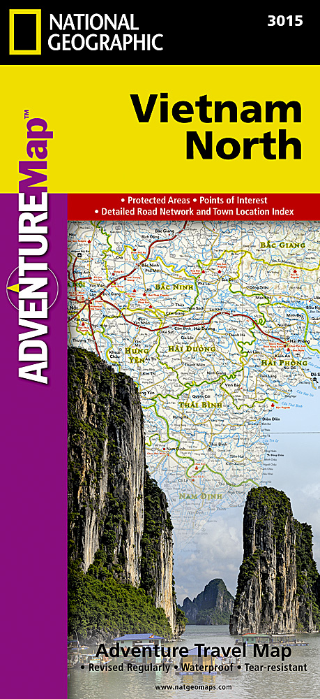
Mooie, heldere kaart van het zuidelijk deel van Vietnam, gedrukt op scheurvast en watervast papier. National Geographic's Vietnam, North AdventureMap is designed to meet the unique needs of adventure travelers with its durability and accurate information. Each folded map provides global travelers with the perfect combination of detail and perspective, highlighting the area s terrain and best locations for adventure activities like snorkeling, surfing, fishing, and more. AdventureMaps include hundreds of points of interest that highlight diverse and unique destinations within the region. The map includes the locations of thousands of cities and towns with a user-friendly index, plus a clearly marked road network complete with distances and designations for major highways, main roads, and tracks and trails for those seeking to explore more remote regions. The front side of the Vietnam North map details the north central region of the country, from its border with Laos to the west, to the Gulf of Tonkin to the east. The reverse side of the map details the northern region, from its border with Laos to the west, China s border to the north, and Gulf of Tonkin to the east. AdventureMaps are printed in the United States on a durable synthetic paper, making it waterproof, tear-resistant and tough capable of withstanding the rigors of international travel. The map is two-sided.
€17,50
Bekijk product
Mooie, gedetailleerde topografische kaart van het oosten van Kirgizië en een klein gedeelte van China en Kazachstan. Met hoogtelijnen en reliëfkleuren, uitgebreide legenda en veel detail. Inclusief korte geografische woordenlijst.
€19,95
Bekijk product
Tweetalige kaart (Engels en Duits). Door ingetekende lengte- en breedtegraden is het gebruik van GPS mogelijk. Met hoogtelijnen en uitgebreid wegennetwerk: daarnaast worden ook de afstanden tussen belangrijke plaatsen duidelijk leesbaar weergegeven. Het kleurgebruik is zodanig dat je een goede indruk krijgt van hoogteverschillen en soorten landschap. Natuurlijk staan de toeristische bezienswaardigheden duidelijk vermeld. Gedrukt op water- en scheurvast papier! Polyart is een synthetisch product vrij van giftige stoffen dus duurzaam. Het papier gaat echt lang mee. Topography is indicated by altitude colouring with numerous spot heights and names of mountain ranges and passes. Salt lakes, swamps, seasonal rivers and glacier are also shown. Detailed presentation of the road network includes minor roads and tracks and railways are also shown. Internal administrative units are presented with their boundaries and names. National parks and other protected areas are highlighted. A wide range of symbols mark various places of interest. Map legends include English and all the maps have an index of localities.
€11,50
Bekijk product
Jasper National Park kaart, zeer gedetailleerd (schaal 1:250.000) plus op de anderekant van de kaart staat Noord Alberta, schaal 1:1.000.000. Natuurkundige overzichtskaart met veel plaatsen en wegen, spoorlijnen en rivieren, hoogten, lengte- en breedtegraden. Two words immediately come to my mind if I were to describe Northern Alberta: Oil and Cold. Oil sands could be found relatively easily within the Northern Alberta region. This pushes the Canadian economy forward as gasoline and other petroleum products are becoming higher in demand. Northern Alberta is also about the subzero temperature. The region of Northern Alberta mostly contains very cold, long winters and warm, short summers. Fort McMurray, for example, one of the famous urban communities located in the Wood buffalo municipality, has only a yearly mean temperature of 0.7 degrees Celsius. Nonetheless, Northern Alberta is also a land of recreation activities and wild adventures. On the other side of the Northern Alberta map, we have included a map of Jasper National Park. This park is situated deep in the Alberta Rockies and is surrounded by mountains. Although it is dissected by the Trans-Canada Highway, this park remains as one of the most pristine and wild parks of Canada. This park is a must-see as it can be reached with ease and has amazing natural features. Included insets of this map are Jasper and Edmonton. Legend Includes: Roads by classification, Airports, Ferries, Train Stations, Bus Terminals, National Parks, Hot Springs, View Points, Points of Interest, Mountain Peaks, Fishing Sites, Camping Sites, Picnic Areas, Golf Fields, Ski Sites, Waterfalls, Gas Stations, Universities, Museums, Post Offices, Police Stations, Swimming Pools, Theatres, Libraries, Restaurants, Hospitals and more.
€13,95
Bekijk product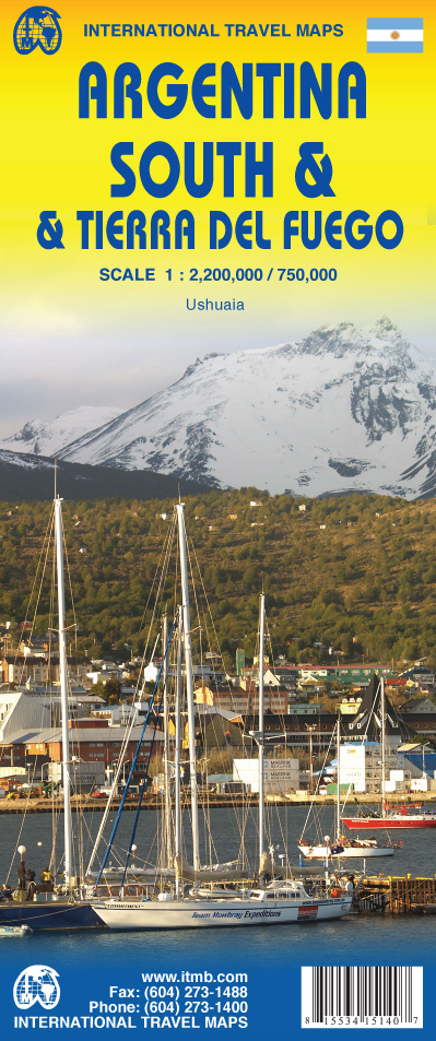
Een degelijke kaart met aanduidingen van o.a. nationale parken, vliegveld, benzinepomp, dirt-roads etc. Als overzichtskaart goed te gebruiken. Op één kant van de kaart staat het zuiden van Argentinië (schaal 1:2.200.00) en op de andere kant staat Tierra del Fuego (schaal 1:750.000). We have switched focus from Northern Argentina and Buenos Aires to Southern Argentina and Tierra del Fuego. This long stretch of South America's second largest country lies beside Chile and is home to many whales and sea lions watching sites. Throughout this long strip of a combination of mountains, seas, and forests, tourists will find this land to be unique and natural. On the other side of this map and at the very end of the two countries sits the famous Land of Fire island, Tierra del Fuego. This triangle shaped island is both part of Chile and Argentina and has been a desirable tourist destination. We have also included an inset map of Ushuaia, "the southernmost city in the world" that is closest to the South Pole. Legend Includes: Roads by classification, Airports, Ferries, Lighthouses, Hot Springs, View Points, Beaches, Ruins, Historical Sites, World Heritage Sites, Border Crossings, Points of Interest, Gas Stations, Museums, Churches, Post Offices, Shopping Centres, Monuments, Volcanoes, Camping Grounds, Oil Fields, Restaurants and more.
€13,95
Bekijk product
Een degelijke kaart met aanduidingen van o.a. nationale parken, vliegveld, benzinepomp, dirt-roads en kleine plattegrond van verschillende steden. Als overzichtskaart goed te gebruiken. De kaart is aan twee zijden bedrukt, de ene zijde omvat de Cayman Islands (schaal 1:37.500 en 1:70.000). Op de andere zijde staat de kaart van Jamaica (schaal 1:250.000) en plattegronden van onder andere Kingston. We are pleased to announce the latest new Caribbean map to our growing series. The Caymans, for there are three major islands and numerous little shoals, remains a British colony, like the British Virgin Islands, the Turks and Caicos, and Bermuda. Tourism is the number one industry of the Cayman Islands, with dozens of hotels dotting the beachfronts, especially north of George Town. There are numerous dive sites for viewing tropical fish and we have shown about a hundred on the map, as well as every side street and gas station. One interesting place to visit is Hell, which is a frozen lava eruption at the north end of Grand Island that looks like, well, hell. The reverse side of the map includes a map of Jamaica and Kingston. This is included for marketing purposes only, for those planning on visiting both islands. Legend Includes: Roads by classification, County Boundary, Parish Boundary, Highway, Main Road, Secondary and other Road, Track, Railway, National Highway Number, Capital, City, Parish Capital Town, Town and Small Town, Village, River and Seasonal River, Swamp, Park, International Airport, Landing Ground, Bus Station, Gas Station, Lighthouse, Harbour, Fort, Hotel, Restaurant, Museum, Monument, University and College, Point of Interest, Beach, Tourist Information Centre, Cove, Golf Course, Pass, Surfing, National Park, Waterfall, Sugar Estate, Viewpoint, Mountain Peak, Marina and Sea-Port, Diving, Hiking Trail, Hospital and much more
€13,95
Bekijk product
Zoals je van Michelin mag verwachten is deze kaart zeer overzichtelijk en heeft een duidelijk helder kaartbeeld. De kaart geeft uitgebreid toeristische informatie weer. De ideale wegenkaart voor een deel van Belgie. Michelin wegenkaarten behoren nog altijd tot de beste in hun soort. De goed uitgebalanceerde cartografie toont precies datgene wat de lezer wil zien (en ook niet meer dan dat!), dat wil zeggen een duidelijke en contrastrijke weergave van alle wegen (van groot tot klein), veel details voor zowel automobilisten als fietsers (kilometerafstanden, pompstations, wegnummers, campings, reliëf, ), gedetailleerde weergave van woonkernen (bij een schaal van 1:200.000 of fijner) en tenslotte een prettig spaarzaam gebruik van toeristische symbolen en weergave landschappelijke details. Charleroi, Liège, Mons, Namur
€11,95
Bekijk product
Een degelijke kaart met aanduidingen van o.a. nationale parken, vliegveld, benzinepomp, dirt-roads en kleine plattegrond van hoofdstad. Als overzichtskaart goed te gebruiken. Very detailed, double sided road and travel map, scale 1:390,000, includes inset map of Sofia and extensive place name index. Distinguishes roads ranging from motorways to local roads. Legend includes tracks/paths, railways, border crossings, national parks, mountain huts, castles/fortresses, monasteries, churches, archaeological sites, other points of interest, camp sites, beaches, caves, international/domestic airports.
€13,95
Bekijk product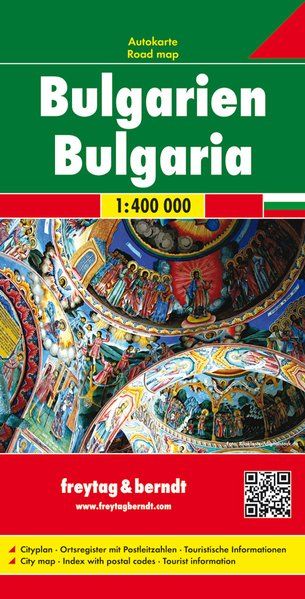
Uitstekende kaart van Bulgarije. Met index, toeristische informatie en afstanden in kilometers. Tweetalig! Goede duidelijke wegenkaart. Wel een grote lap kaart, maar daardoor bestrijkt het een groot gebied. Alle toeristische details staan er op, ook campings worden vermeld. Gedetailleerde, tweezijdige landkaart, prima geschikt voor planning en rondtrekken. De berijdbare wegen zijn goed weergeven, zowel de hoofdwegen als provinciale en lokale wegen; wegnummers worden vermeld. Afstanden tussen plaatsen zijn in kilometers op de kaart ingetekend, daarnaast worden ook op belangrijke plekken benzinepompen gemarkeerd. In het kaartbeeld wordt door middel van schaduw het reliëf weergegeven en soms enkele punten in het landschap met de daadwerkelijke hoogte. Provinciegrenzen zijn goed terug te vinden, nationale parken en reservaten ook. Met allerhande symbolen worden toeristische bezienswaardigheden weergegeven als monumenten, historisch belangrijke plekken en uitzichtpunten. In bepaalde plaatsen zijn hotels en campings te vinden, luchthavens, treinverbindingen en havens vindt u er ook op!
€14,95
Bekijk product