
Beantwoord enkele vragen, en binnen seconden geeft AI je een persoonlijk aankoopadvies op maat.
Beantwoord enkele vragen, en binnen seconden geeft AI je een persoonlijk aankoopadvies op maat.
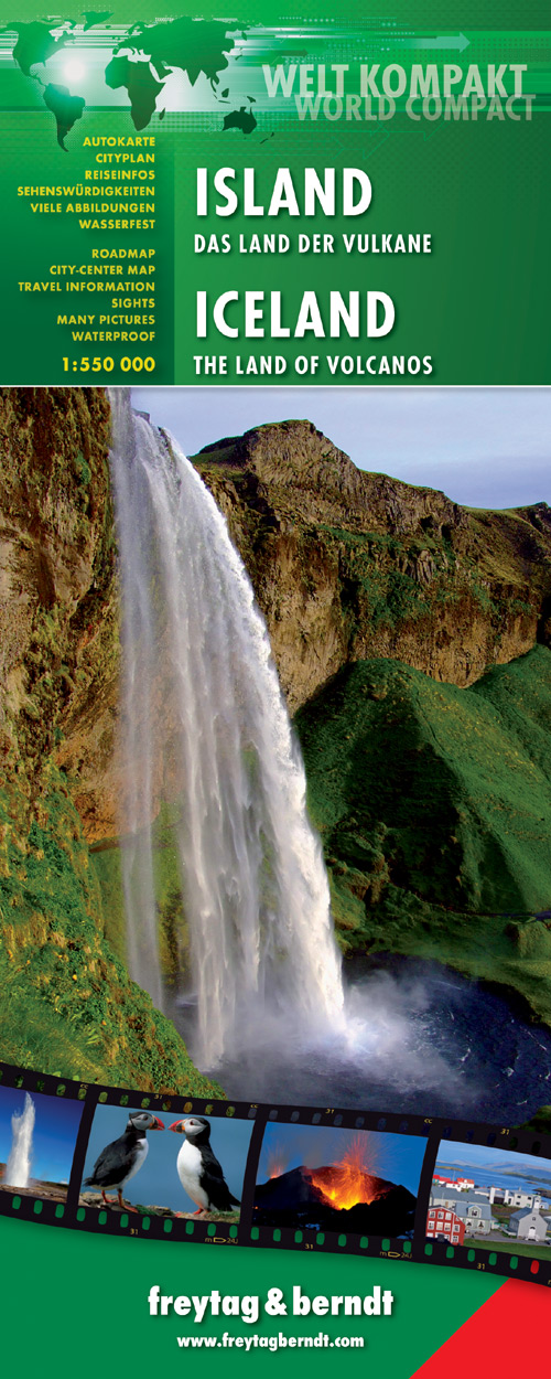
Gedetailleerde, geplastificeerde landkaart van IJsland met toeristische informatie en stadsplattegronden Freytag and Berndt tourist map and road map of Iceland - world compact series includes Top tourist information, city maps, text in English and German, waterproof map Freytag und Berndt Autokarte Island Welt Kompakt 1:550.000 führt Sie in das Land der Vulkane. Beschreibung der Top-Sehenswürdigkeiten finden Sie auf dieser Übersichtskarte inklusive Stadtpläne, sowie touristische Informationen, Länderinformationen und einen Sprachführer. Sprachen: Deutsch, Englisch reiß- und wasserfest Duidelijk minder gedetailleerd dan de andere Freytag kaart van IJsland, maar groot voordeel is dat deze geplastificeerd is.
€14,95
Bekijk product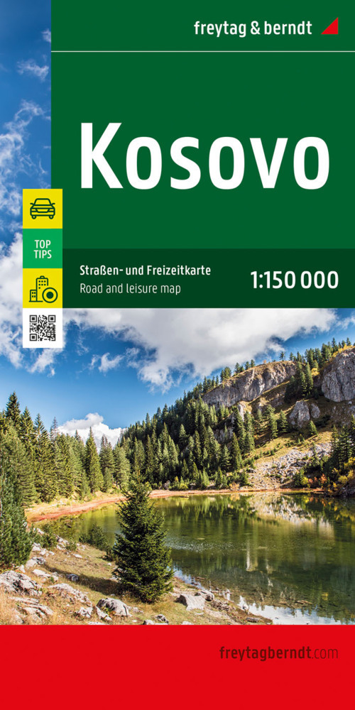
Uitstekende wegenkaart van Kosovo. Met index, toeristische informatie en afstanden in kilometers. Gedetailleerde, eenzijdige landkaart van Kosovo, prima geschikt voor planning en rondtrekken. De berijdbare wegen zijn goed weergeven, zowel de hoofdwegen als provinciale en lokale wegen; wegnummers worden vermeld. Afstanden tussen plaatsen zijn in kilometers op de kaart ingetekend, daarnaast worden ook op belangrijke plekken benzinepompen gemarkeerd. In het kaartbeeld wordt door middel van schaduw het reliëf weergegeven en soms enkele punten in het landschap met de daadwerkelijke hoogte. Provinciegrenzen zijn goed terug te vinden, nationale parken en reservaten ook. Met allerhande symbolen worden toeristische bezienswaardigheden weergegeven als monumenten, historisch belangrijke plekken en uitzichtpunten. In bepaalde plaatsen zijn hotels en campings te vinden, luchthavens, treinverbindingen en havens vindt u er ook op! This detailed road map of Kosovo is very suitable for planning and traveling around the country. The road network is well represented, both the main roads, provincial and local roads. Road numbers are also clearly stated. Distances between places are marked on the map in kilometers, and gas stations are also marked in important places. Shadow shows the relief and sometimes some points with the actual height. Province borders, national parks and reserves are easy to find. Symbols indicate the location of tourist sites, monuments, historically important places and viewpoints. In certain places you can find hotels and campsites, airports, train connections and ports. Mit der Straßenkarte Kosovo im Maßstab 1:150.000 finden sich Urlauber die mit Auto, Motorrad oder Wohnwagen unterwegs sind bestens zurecht. Das weit verzweigte Straßennetz ist exakt abgebildet, Entfernungen und viele Ausflugsziele sind in der Karte eingezeichnet. Informationen zur Straßenkarte KosovoMaßstab 1:150.000Touristische InformationenCampingplätze und StellplätzeOrtsregister mit PostleitzahlenCityplan Pristinaca. 94,5 x 125 cm Auto- und Motorradfahrer schätzen die exakte Kartographie von freytag & berndt besonders für die Planung und Orientierung vor Ort. Wohnwagenfahrer und Camper finden in der Karte natürlich alle Campingplätze und Stellplätze. Top Tips Auf der Kartenrückseite sind die wichtigsten Sehenswürdigkeiten der Region kurz beschrieben. (Sprachen: Deutsch, Englisch, Albanisch, Serbisch). Gedruckt in Österreich.
€14,95
Bekijk product
Goede wegenkaart van een deel van Australie: Sydney tot Brisbane. A city to city map designed for the journey from Sydney to Brisbane via the Pacific and New England Highways (1:1,000,000), with tourist information on towns and regions within the trip on the opposite side. City maps 24-hour fuel Camping areas Distance grids Tourist attractions Roadside rest areas
€17,50
Bekijk product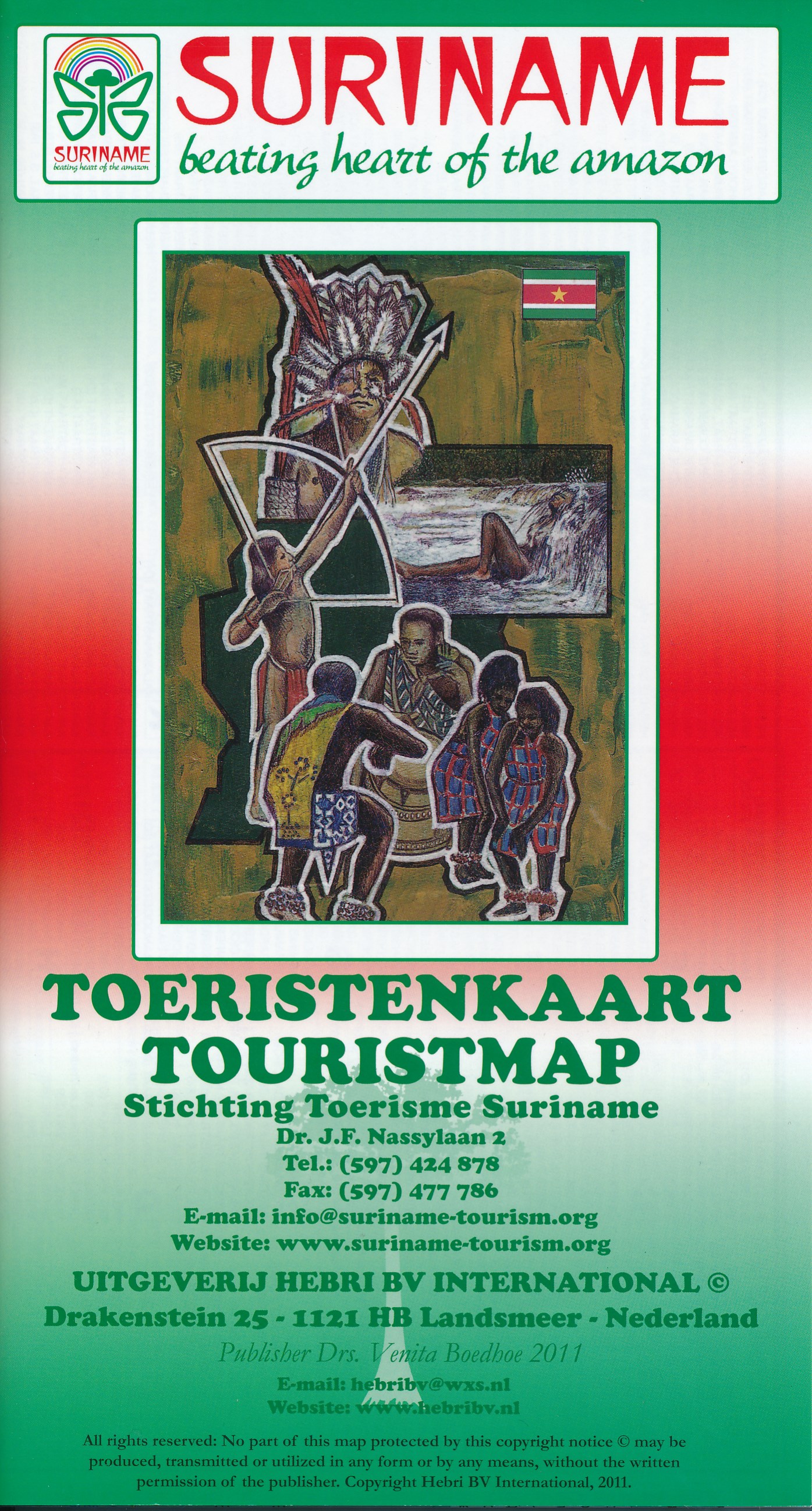
Geplastificeerde wegenkaart van Suriname. Groot pluspunt is de plattegrond van Paramaribo op de andere zijde van de kaart; niet echt een zeer goede kaart van de stad, maar bij gebrek aan beter is dit een behoorlijke houvast om je weg te vinden.
€13,75
Bekijk product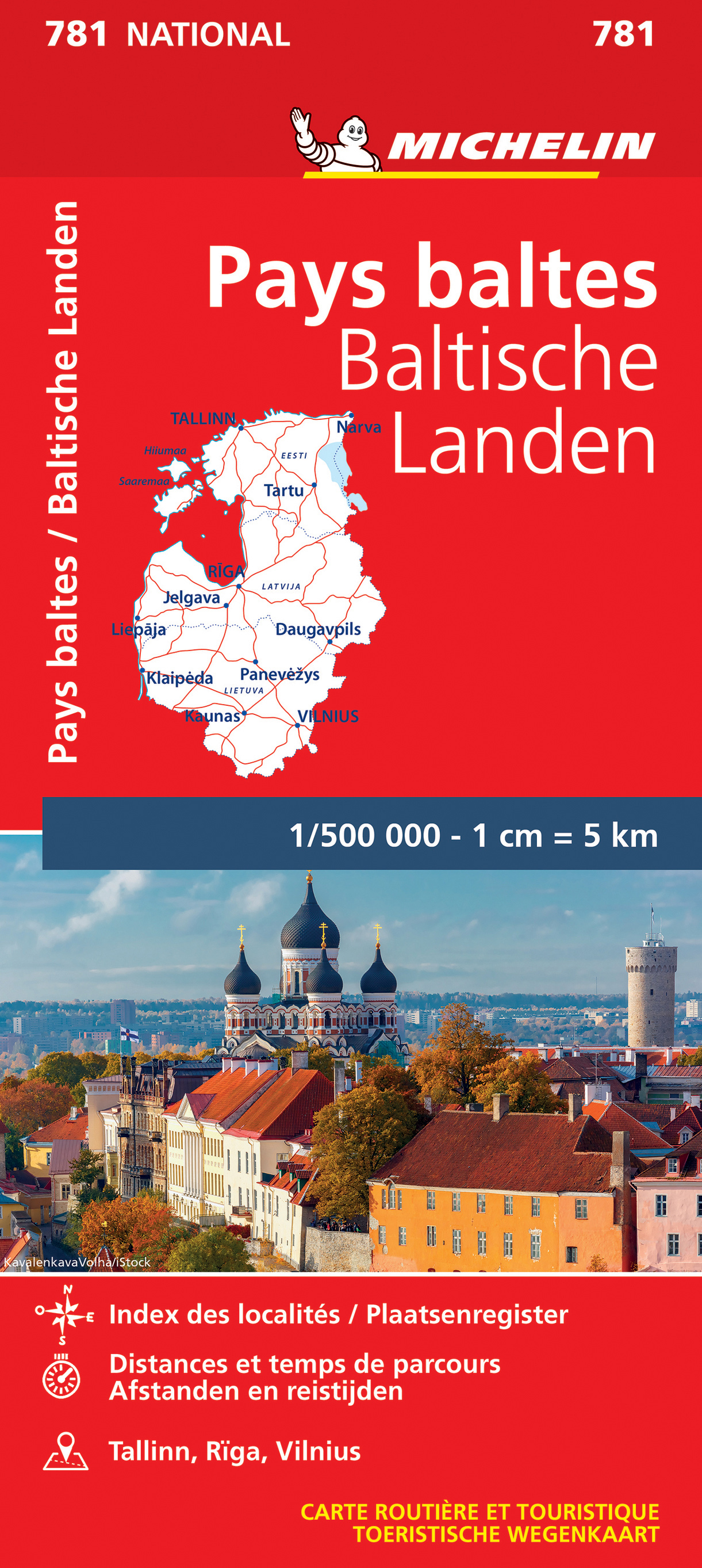
Zoals je van deze landkaart van Michelin mag verwachten is deze wegenkaart Baltische Staten zeer overzichtelijk en heeft een duidelijk helder kaartbeeld. De kaart geeft uitgebreid toeristische informatie weer. This Baltic States map from Michelin is part of their red national map series. These are perfect for route planning as well as getting around by car once you're there. They clearly mark out major roads and also show many of the more important minor roads. The map covers Estonia, Latvia, and Lithuania and includes several insets showing Tallinn at 1:10 000, Riga at 1:10 000 and Vinius at 1:10 000. The map's simple folding design with durable paper cover, allows it to be read like a book and easily folded back together. Road numbers and intermediate distances are clearly displayed with the more scenic routes highlighted in green. The map also features: Political boundaries Regional and National Parks Important sights such as castles, ruins, and churches Driving Times and Distances Road Safety Information A legend in multiple languages (Dutch, English, French, German and Spanish) Estonie, Lettonie, Lituanie, Pays Baltes
€11,95
Bekijk product
Deze kaart maakt deel uit van meerdere gedetailleerde topografische kaarten van het Atlas Gebergte en de daaraan grenzende woestijnen. Elke kaart heeft lokale toeristische info op de achterzijde en is in het Frans en Engels beschreven Hoogte in hoogtelijnen met 40m interval en een aantal punten. Verdere vermelding van terreinsoort, vegetatie, waterpunten, kliffen, duinen, ravijnen, zoutpannen etc. Bij wegen onderscheid in onverhard, verhard en tracks. Bebouwing, vliegvelden, stations, elektrische leidingen. Voor sommige passen is er een indicatie wanneer deze begaanbaar is. De uitgever EWP meldt dat deze kaarten geschikt zijn voor het gebruik van GPS: "The main grid drawn over the mapping is based on the Kronstadt system which related closely to the UTM system, and which the publishers assure us is suitable for a GPS set to UTM or MGRS".
€19,95
Bekijk product
Goede kaart van een deel van India. Aan beide kanten bedrukt. Met veel toeristische aanduidingen als nationale parken en culturele bezienswaardigheden. Prima leesbare kaart. Detailkaart: Kolkata (Calcutta) en Varanasi One of five maps in a series covering India at 1:1 500 000 scale. Folded road and tourist map of eastern India, including Nepal and southern Tibet to the north, Calcutta to the east, Visakhapatnam to the south, and Kanpur and Jabalpur on the western edge of map. Points of interest, national parks and railways are all highlighted and shaded-relief colouring clearly depicts the topography. The map includes insets showing regional Kolkata (Calcutta) at 1:300 000 and a locator map. The legend is in English, French and German. The other titles in the series are India North, India North East, India South, and India West. Nelles also produces a map of the whole Indian Subcontinent at a scale of 1:4 500 000. For over 20 years Nelles maps have been renowned throughout the world for their quality, faithfulness to detail and up-to-dateness. So that streets, ferry links, railway lines, etc are always up to date, Nelles are continuously upgrading their maps - with the help of their international team of correspondents. Roads are provided with an exact kilometerage. Sights are highlighted extra clearly so that you don't miss any tourist attractions. A good map must be hard-wearing and allow itself to be folded up simply and quickly. Nelles Maps are a handy pocket size with the reliable, practical concertina fold. In addition they use an extra high-quality speciality paper resulting in considerably increased fold strength.
€11,95
Bekijk product
Goede kaart van een deel van India. Aan beide kanten bedrukt. Met veel toeristische aanduidingen als nationale parken en culturele bezienswaardigheden. Prima leesbare kaart, nu geplastificeerd! Andaman and Nicobar Islands 1 : 1.500.000 Goa 1 : 750.000 Lakshadweep 1 : 1.500.000 Bangalore 1 : 50.000 Chennai (Madras) 1 : 50.000 Hyderabad 1 : 50.000 Thiruvananthapuram (Trivandrum) 1 : 50.000
€11,95
Bekijk product
Freytag & Berndt kaarten op schaal 1:50.000 (of kleiner) zijn zeer overzichtelijk, wandelpaden werden erop ingekleurd, ze bevatten voldoende details om een wandeltocht in te schatten. Overigens vinden wij dat de Freytag & Berndt kaarten van de Spaanse en Portugese eilanden iets meer gericht zjin op algemeen toerisme en iets minder op wandelen; voor wandelen raden we toch de Kompass - kaarten serie aan die van de meest eilanden ook voor handen is.
€14,95
Bekijk product
Goede overzichtelijke wegenkaart van de zuidelijke helft van Duitsland met register en afstandentabel. Mit Download-Code für gratis Kartenversion auf Smartphone! Mit E-Distoguide® via QR-Code. Die Vernetzung von Print und Web für noch mehr Flexibilität. Über 2000 Entfernungsangaben sind jetzt mittels QR-Code direkt mit dem Handy überall abrufbar! Strassenkarte mit Transitplänen, Ortsindex, touristische Informationen und Sehenswürdigkeiten. Aktuelle Information, übersichtliche Darstellung, einfache Handhabung: das Markenzeichen der Hallwag-Strassenkarten. Das internationale Programm mit neuen Ideen für besseres Reisen bietet Ihnen überzeugende Vorteile.
€14,50
Bekijk product