
Beantwoord enkele vragen, en binnen seconden geeft AI je een persoonlijk aankoopadvies op maat.
Beantwoord enkele vragen, en binnen seconden geeft AI je een persoonlijk aankoopadvies op maat.

<div> <span style="color: rgb(0, 0, 0); font-family: 'Helvetica Neue', Helvetica, sans-serif, Arial;">Borch Brussel is een duidelijke, geplastificeerde plattegrond van het centrum met informatie over openbaar vervoer en bezienswaardigheden. Inclusief straatnamenregister.</span></div> <div> </div> <div> Our soft-laminated folded map of Brussels shows: Brussels 1:12 000, Brussels Center 1: 10 900, Grand Place, Brussels Region 1:100 000, Public Transport Brussels and Belgium administrative. Borch maps are easy to fold, durable and water-repellent with a wipeable surface. Borch Maps show hotels, museums, monuments, markets, top sights and points of interest, useful statistics, conversion charts for temperatures, weights and measurements, climate charts showing temperatures, sunshine hours, precipitation and humidity, overview maps, time zones, and much more...</div> <div> </div> <div> Brussels is considered the capital city of the European Union because of the numerous EU institutions headquartered here. Organisations with their main seat in Brussels include the North Atlantic Treaty Organisation (NATO) and the European Organisation for the Safety of Air Navigation (Eurocontrol). Apart from being the capital city of Belgium, Brussels is the capital of the French Community of Belgium and the capital of Flanders. Brussels is a European metropolis situated almost directly in the center of the small country. Notable trademarks of Brussels include the Grande Place, a beautiful gothic market ensemble, the recently renovated Atomium from the 1958 World Expo and "Manneken Pis" - the child of the city. Brussels stands for exquisite cuisine, delicious Belgian chocolates and intricate lacework. Interesting museums, galleries, art-deco architecture, fine shopping and nightlife, all distinctly European, await the visitor. Europe par excellance!</div> <div> </div>
€9,95
Bekijk product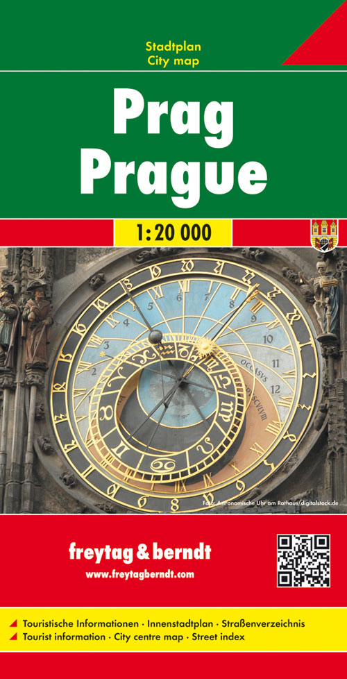
<p> Stadsplattegrond van Praag: duidelijk leesbaar, klein register.</p> <p> Stadsplattegrond met register. Helder kaartbeeld waarbij de naamgeving goed leesbaar is weergegeven. Met de toeristische bezienswaardigheden in symbolen weergeven. Veelal ook met een openbaar vervoer of metro kaart als inzet.</p> <div> Large indexed street plan of Prague including its outer suburbs, with a clear enlargement of the central tourist districts of the city, the Old Town and Mala Strana. </div> <div> </div> <div> The main plan extends west, south and east to show access to the city’s inner districts from the E48/E50/E55 motorway ring and includes the international airport. Tram and bus lines are shown with numbers and stops. Metro stations are marked and suburban railway lines are shown with names of local stations. Map legend includes English.</div> <div> </div>
€13,95
Bekijk product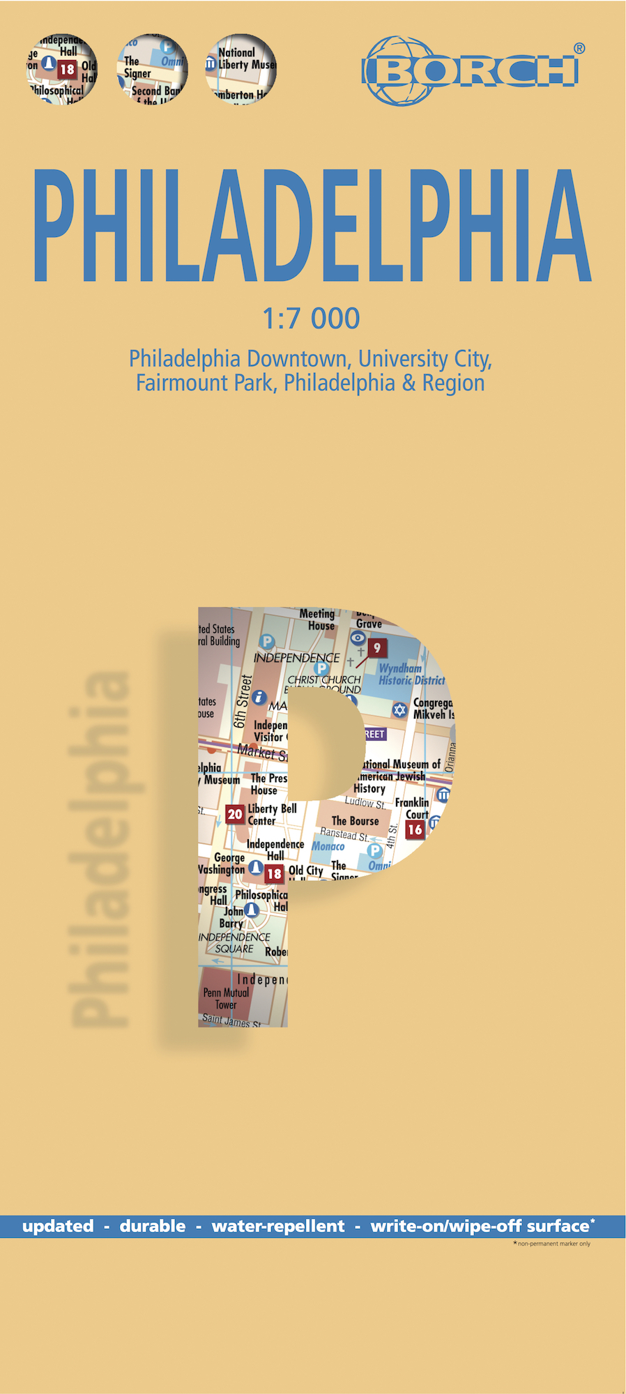
<div> <span style="color: rgb(0, 0, 0); font-family: 'Helvetica Neue', Helvetica, sans-serif, Arial;">Borch Philadelphia is een duidelijke, geplastificeerde plattegrond van het centrum met informatie over openbaar vervoer en bezienswaardigheden. Inclusief straatnamenregister.</span></div> <div> </div> <div> Our soft-laminated folded map of Philadelphia shows: Philadelphia Downtown 1:7 000, Philadelphia & Region 1:125 000, University City 1:12 000, Fairmount Park 1:15 000, Public Transport Philadelphia, Top 30 Sights, USA administrative & time zones. Borch Maps are easy to fold, durable and water-repellent with a wipeable surface. Borch Maps show hotels, museums, monuments, markets, public transport, top sights and points of interest, useful statistics, conversion charts for temperatures, weights and measurements, climate charts showing temperatures, sunshine hours, precipitation and humidity, overview maps, time zones, and much more...</div> <div> </div> <div> Thanks to Benjamin Franklin, one of the founding fathers of the United States, the ideas and actions leading to the American Revolution were formed in Philadelphia and for this reason the city is known as "The Birthplace of America". Philadelphia was the center of the original 13 American colonies and is today the largest city in Pennsylvania. Affectionately called "Philly", Philadelphia is an important commercial, educational and cultural center. The most impressive sight of historical importance is Independence Hall, where the Declaration of Independence was signed and the Liberty Bell can be seen in the nearby Liberty Bell Center. Apart from its many historical museums the city has several art museums, science museums and museums for natural history, archaeology and anthropology. Philly's vibrant night life can be experienced on South Street and in the Old City, and music fans shouldn't miss the Avenue of the Arts in City Center, home to the Philadelphia Opera and Orchestra as well as many excellent restaurants.</div> <div> </div>
€11,50
Bekijk product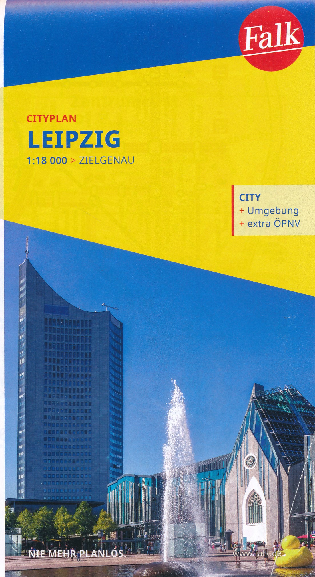
<p> Goede handzame stadsplattegrond van Leipzig met register. Centrumkaartje op betere schaal en een aparte OV inzet. </p> <p> Für deutsche Großstädte sind die Falk Citypläne im Pocket-Format einfach nützlich. Mit Straßenverzeichnis, Durchfahrtsplan und Verkehrslinienplan.</p> <div> Mit dem FALK Cityplan ist man im Kernbereich einer Großstadt unterwegs. Dieser handliche Plan ist der ideale Wegweiser für die schnelle Orientierung in der fremden Stadt. Für den Touristen ist dieser #kleine FALK" bei der Stadtbesichtigung nahezu unentbehrlich. Großflächige Nebenkarten geben wertvolle Auskünfte; man erhält hier Hinweise für eine gezielte Zufahrt, Detailinformationen zum Innenstadtbereich und lernt die schnellen, öffentlichen Verkehrsmittel der Stadt kennen. Wird eine bestimmte Straße gesucht, so findet man diese im Straßenverzeichnis auf der Rückseite des Planes. Neben dem blauen Suchgitter enthalten alle Citypläne ein schwarzes UTM- Gitternetz (nicht bei den Hyperboloid-Projektionen). Das Netz hat eine Maschenweite von 2.000 Metern mit einer Feineinteilung von 100 Metern # einfach ideal zur Entfernungsabschätzung für die Entdeckungstouren durch die Stadt.</div> <div> </div> <div> Hauptkarte 1:20 000 mit mehrsprachiger Legende (D, GB, F) - Cityplan Zentrum Leipzig 1:10 000 - Durchfahrtsplan 1:110 000 - LVB Liniennetzplan; Auf der Rückseite: - Straßenverzeichnis mit Postleitzahlen und Suchfeldangaben - Daten und Fakten</div>
€9,95
Bekijk product
<p> <span style="font-size: 12px;">Stadsplattegrond van Montreal met register. Op de achterzijde een kaart van het zuiden van Quebec.</span></p> <p> <span style="font-size: 12px;">1:12,500/1:850,000 on waterproof paper. In this third, updated, edition of Canada's third largest city, we have added a user-friendly bonus. As is common now to most of our city maps, we have included a regional map of the hinterland of the urban area, so buyers won't have to purchase a second map to explore the environs of the city being presented. In the case of Montreal, being in a huge geographic country, this means Southern Quebec which, because of its size, dictates a map of more than one to a million scale. </span><span style="font-size: 12px;">In the European context this would be the equivalent of Paris and all of France as a 'regional' map of the surrounds of Paris - but that's France and this is Canada.</span></p> <div> </div> <div> <span style="font-size: 12px;">Montreal (or Mont Royale in its original) was a village called Hochelaga when the early French explorers arrived in the early 1600s. They established a trading fort and, generally speaking, maintained good relations with the established natives for the next century or so. The English arrived in 1760, having defeated the French under Montcalm at Quebec City the year previously, and English dominance was reaffirmed by the Treaty of Versailles that ended the Seven Years War. The English allowed the continuation of the French language and legal system throughout Quebec and Montreal prospered. They also got on fairly well with the indigenous tribes. The North American fur trade, with its long transportation routes covering the navigable waters of interior rivers and lakes brought wealth and power to the city by exchanging furs for goods.</span></div> <div> </div> <div> Legend Includes:</div> <div> Roads by classification, Points of Interest, Hotels, Mines, Museums, Churches, Airports, National Parks, Rivers, Lakes, Mountain Peaks, Waterfalls, Border Crossings, Rest Areas, Hospitals, Campgrounds, Picnic Sites, Ski Areas, Ports, Tourist Information, Golf Courses, Fishing Areas, Post Offices, Bicycle Routes, Police Stations, Schools, Monuments, Live Theatres, Cinemas, Bus Stops, and much more.</div> <div> </div> <div> </div>
€13,95
Bekijk product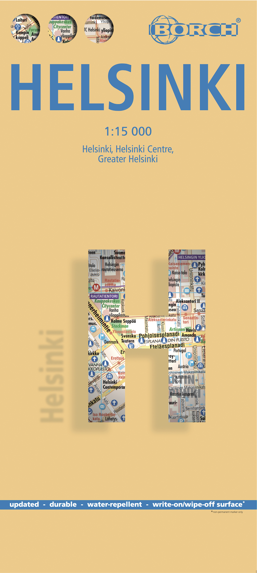
<p> Borch Helsinki is een duidelijke, geplastificeerde plattegrond van het centrum met informatie over openbaar vervoer en bezienswaardigheden. Inclusief straatnamenregister.</p> <div> Our soft-laminated folded map of Helsinki in the 1st edition shows: Helsinki 1:15 000, Helsinki 1:7 500, Greater Helsinki 1:100 000, Public Transport Helsinki, Finland administrative & time zones, Top 30 Sights. Borch Maps show hotels, museums, monuments, markets, public transport, top sights and points of interest, useful statistics, conversion charts for temperatures, weights and measurements, climate charts showing temperatures, sunshine hours, precipitation and humidity, overview maps, time zones, and much more...</div> <div> </div> <div> Called "the daughter of the Baltic", Helsinki is located on the tip of a peninsula and on 315 islands. The Helsinki metropolitan area is home to more than a million people. It has close historical connections with Tallinn, Estonia, Stockholm, Sweden and St. Petersburg, Russia. HelsinkI is the capital and largest city of Finland. Helsinki (Helsingfors in Swedish) is the northernmost metropolitan area in the world. Established by King Gustav I of Sweden in 1550, Helsinki consistently ranks very highly in the worlds top ten most livable cities. Due to the mitigating influence of the Baltic Sea and the North Atlantic Current, temperatures in winter are higher than the northern location might suggest, with temperatures in January and February averaging -5 C. Helsinki is also known as a hub of industrial design! In Helsinki slang the city is called Stadi (from the Swedish word stad, meaning "city").This truly fine city must be seen.</div>
€9,95
Bekijk product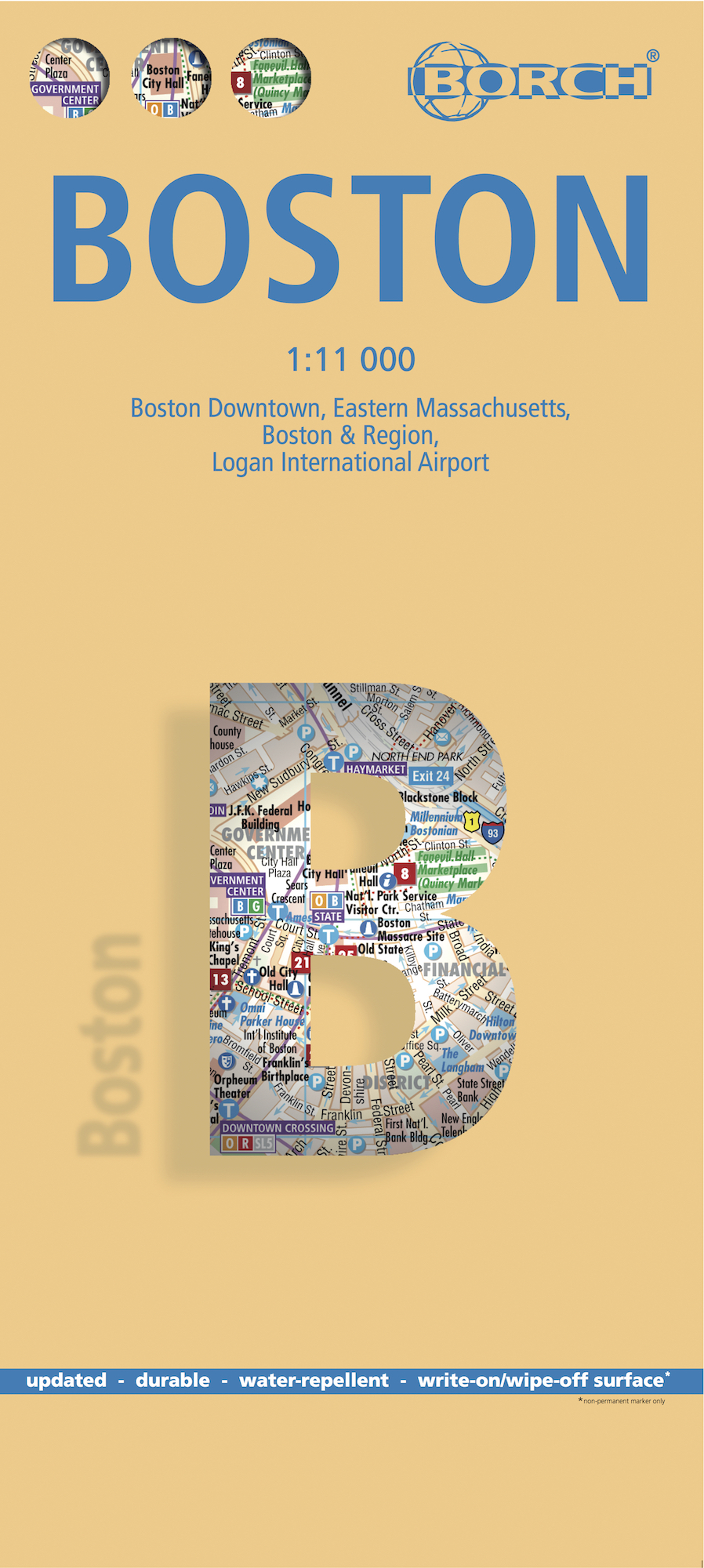
<div> <span style="color: rgb(0, 0, 0); font-family: 'Helvetica Neue', Helvetica, sans-serif, Arial;">Borch Boston is een duidelijke, geplastificeerde plattegrond van het centrum met informatie over openbaar vervoer en bezienswaardigheden. Inclusief straatnamenregister.</span></div> <div> </div> <div> Our soft-laminated folded map of Boston shows: Boston Downtown 1:11 000, Eastern Massachusetts 1:600 000, Boston and Region 1:200 000, Logan International Airport 1:33 000, Public Transport Boston, Top 30 Sights and USA administrative and time zones. Borch maps are easy to fold, durable and water-repellent with a wipeable surface. Borch Maps show hotels, museums, monuments, markets, top sights and points of interest, useful statistics, conversion charts for temperatures, weights and measurements, climate charts showing temperatures, sunshine hours, precipitation and humidity, overview maps, time zones, and much more...</div> <div> </div> <div> Founded in 1630, Boston is often referred to as the cradle of American democracy, due to major events having taken place here during the American Revolution. Boston is an important port and manufacturing center and is today one of the new world's most culturally relevant old cities. Boston is the capital of the Commonwealth of Massachusetts and Greater Boston is America’s 11th largest metropolitan area. Boston's residents are known as "Bostonians" and the city is acclaimed as a center of education and healthcare, with a solid, long-standing economy based on finance, research and technology, primarily biotechnology. Re-live history along the famous Freedom Trail, experience the Irish Heritage Trail from the waterside, feel like a scholar on the campus grounds of Harvard University and M.I.T., visit the museums, theaters and markets; there's really something for everyone in Boston, a beautiful, historical city unquestionably worth a visit.</div> <div> </div>
€9,95
Bekijk product
<p> Falk Stadtpläne Extra Standardfaltung: Der detailgenaue, aber dennoch übersichtliche Stadtplan ist die ideale Orientierungshilfe in der fremden Stadt. Ob im Zentrum oder im Randbereich, mit dem Falk Stadtplan Extra findet man jedes gesuchte Ziel. Der Plan ist dank seiner Leporello-Faltung sehr leicht zu handhaben. Den Reisenden wird dieser Falk Stadtplan ein unentbehrlicher "Fremdenführer" sein, zeigt er doch neben dem umfangreichen Straßenverzeichnis und den Postleitzahlen auch alle für den Touristen wichtigen Informationen. Die Straßenkarte, 1:150.000 auf der Rückseite des Stadtplanes, bietet zusätzlich noch interessante touristische Hinweise für die Umgebung der Titelstadt. Nebenkarten sind für einen schnellen Zugriff geschickt im Beiheft platziert und zeigen Detailinformationen zum Innenstadtbereich, bilden Übersichten zum Thema Öffentlicher Nahverkehr ab und geben wertvolle Auskünfte zu den Postzustellbezirken. Mit dem Falk Stadtplan Extra haben Sie also alles Wichtige stets im Blick.</p>
€13,95
Bekijk product
<p> De stadsplattegronden van Lonely Planet zijn uitgevoerd op scheur- en watervast papier, zijn lichtgewicht en kennen een handig formaat. Het centrum van de stad is in heldere kleuren in beeld gebracht met straatnamen, bezienswaardigheden en symbolen voor openbaar vervoer. Op de achterzijde staat informatie over de toeristische hoogtepunten en in de meeste gevallen een schematische plattegrond van het openbaar vervoer. Met een register.</p> <p> Durable and waterproof, with a handy slipcase and an easy-fold format, <b><i>Lonely Planet Beijing City Map</i></b> is your conveniently-sized passport to traveling with ease. Get more from your map and your trip with images and information about top city attractions, walking tour routes, transport maps, itinerary suggestions, extensive street and site index, and practical travel tips and directory. With this easy-to-use, full colour navigation tool in your back pocket, you can truly get to the heart of Beijing, so begin your journey now!</p> <ul> <li> <b>Durable and waterproof</b></li> <li> <b>Easy-fold format and convenient size</b></li> <li> <b>Handy slipcase</b></li> <li> <b>Full colour and easy-to-use</b></li> <li> <b>Extensive street and site index</b></li> <li> <b>Images and information about top city attractions</b></li> <li> <b>Handy transport maps</b></li> <li> <b>Walking tour routes</b></li> <li> <b>Practical travel tips and directory</b></li> <li> <b>Itinerary suggestions</b></li> <li> <b>Covers</b> The Forbidden City, Dongcheng, Temple of Heaven Park, Beihai Park, Xicheng, Chaoyang, Haidian and more</li> </ul> <p> <b>Check out <i>Lonely Planet Beijing</i>, our most comprehensive guidebook to the city, covering the top sights and most authentic off-beat experiences. Or check out <i>Lonely Planet Pocket Beijing</i>, a handy-sized guide focused on the can't-miss experiences for a quick trip.</b></p> <p> </p>
€9,95
Bekijk product
<div> Geplastificeerde centrumkaart van Perth, met register. Voor <span style="font-size: 12px;">de 'gewone' toerist een handige kaart, geen groot formaat, </span><span style="font-size: 12px;">overzichtelijk met alle belangrijke plaatsen goed weergegeven. </span></div> <div> </div> <div> This laminated fleximap of Perth contains six maps, including Perth City, Perth environs, Perth Urban area, Fremantle, and an overview regional map. It also gives overviews of the top recommended sights and places to visit, as well as practical data, climate tables and local transport details. The key features include: detailed cartography highlights all the main tourist sights and provides valuable motoring information; informative text - essential facts about the destination are provided, plus handy tips for getting around...; ease of use - the durable maps fold very easily, even when it's raining; and laminated finish - you can write on the map with a non-permanent marker pen and wipe it off later.</div>
€9,95
Bekijk product