
Beantwoord enkele vragen, en binnen seconden geeft AI je een persoonlijk aankoopadvies op maat.
Beantwoord enkele vragen, en binnen seconden geeft AI je een persoonlijk aankoopadvies op maat.
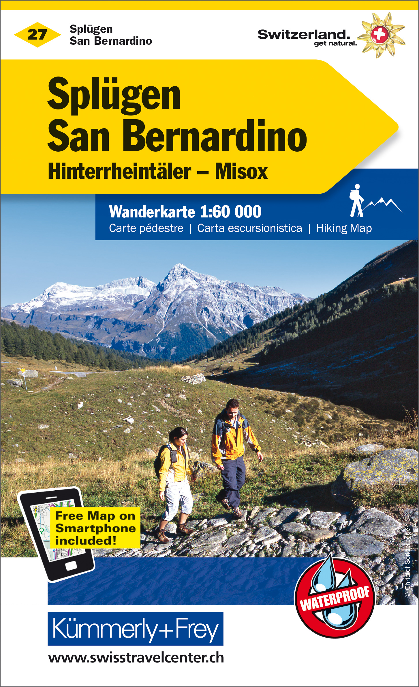
<p> Zeer duidelijke wandelkaart van een deel van Zwitserland. Deze kaart - gemaakt op scheur en watervast papier - is bedoeld voor de gewone en gemiddelde bergwandelaar. Ook voor huttentochten is deze zeker geschikt. Slechts voor de gevorderde wandelaar die glesjers gaat overschrijden zijn de 25.000 topografische kaarten aan te raden.</p> <div> Op deze 1:60.000 kaarten staan de wandelroutes in 3 soorten weergegeven: Wanderweg, Bergweg en Alpine route. De routes staan goed ingetekend en werken prima naast de vele markingen in het veld. Hoogteverschillen, overnachtingsmogelijkheden, bus routes en gps-informatie ontbreken allemaal niet op deze landkaarten.</div> <div> </div> <div> The maps have contours at 50m or 25m intervals according to the terrain, enhanced by graphic relief and shading. An overprint distinguishes between sign-posted hiking paths, mountain path where proper walking shoes are necessary, and alpine paths requiring special equipment.</div> <div> </div> <div> Mountain huts are marked, plus various types of accommodation: campsites, youth hostels, “Friends of Nature” Houses, and secluded hotels and restaurants. Road network indicates local bus routes with stops. Railways, narrow gauge mountain railways, cable car lines, and chair lifts are shown, with various symbols highlighting places of interest, viewpoints, picnic sites, swimming pools, etc.</div> <div> </div> <div> Each title covers an area of approximately 60 x 42 km (37 x 26 miles). The maps have a 1km grid for GPS users, with latitude and longitude shown as margin ticks. Map legend includes English. On the reverse, an index of towns and villages includes names of geographical features such as mountains, alpine passes, glaciers, lakes, rivers, as well as places of interest.</div>
€22,50
Bekijk product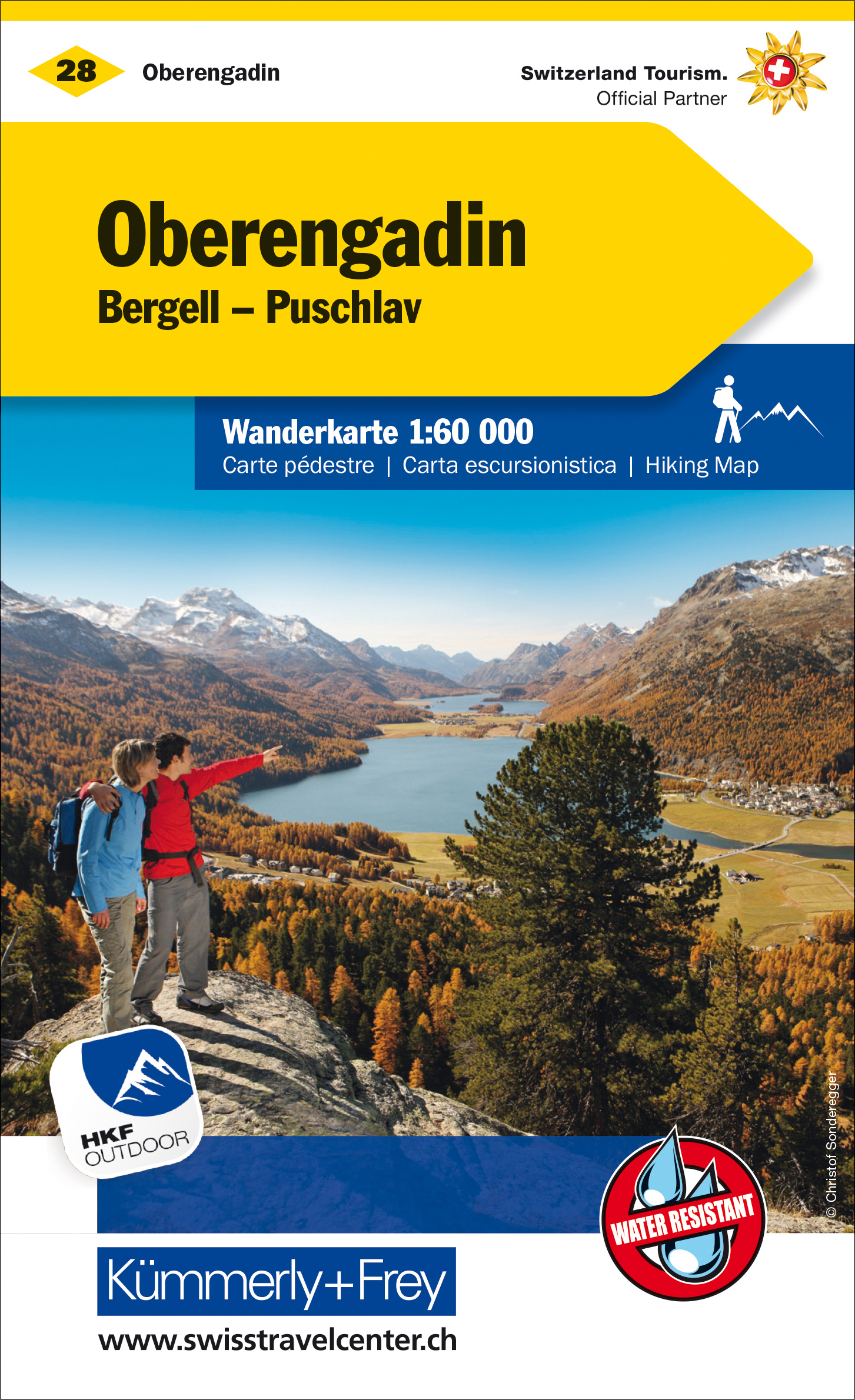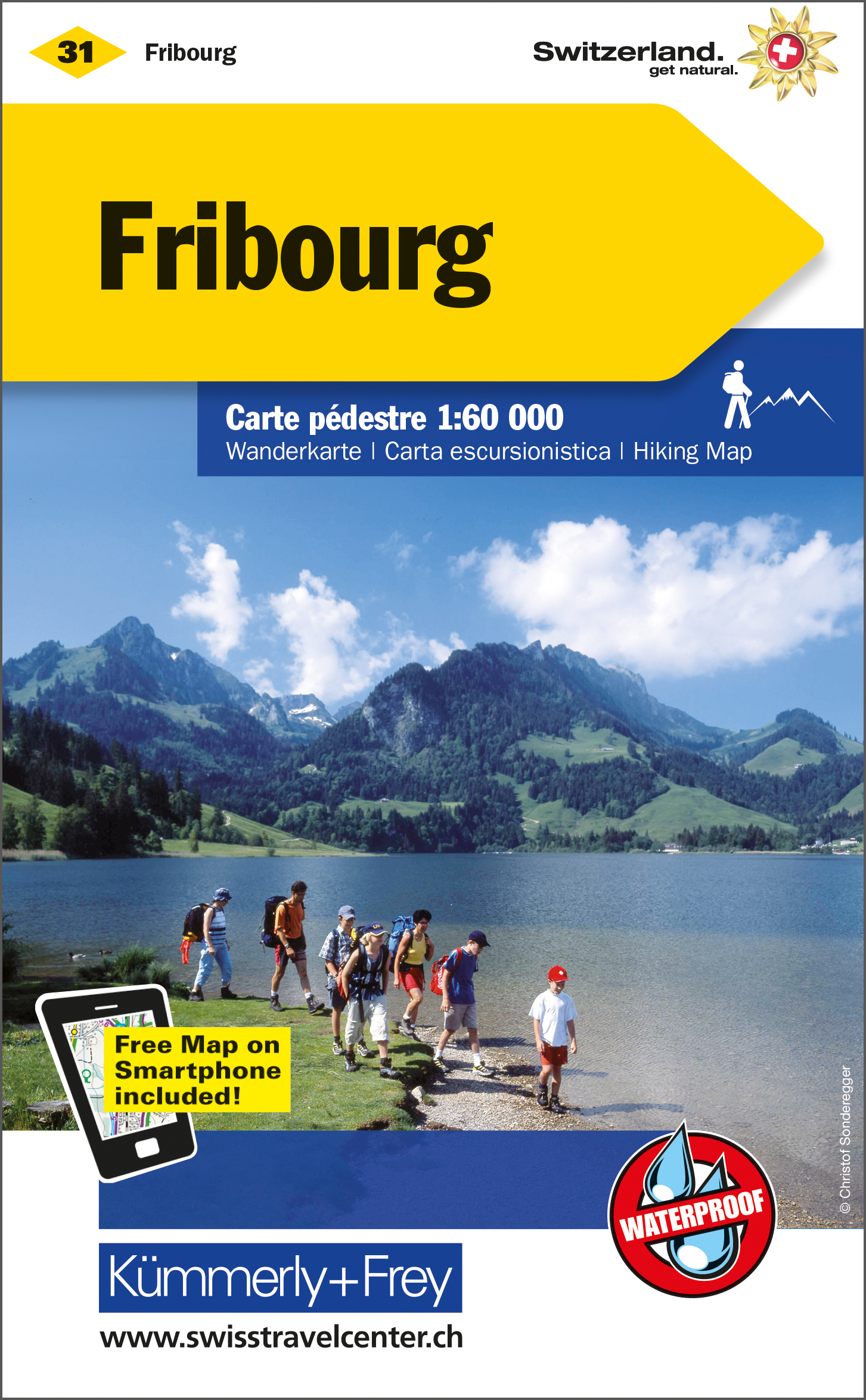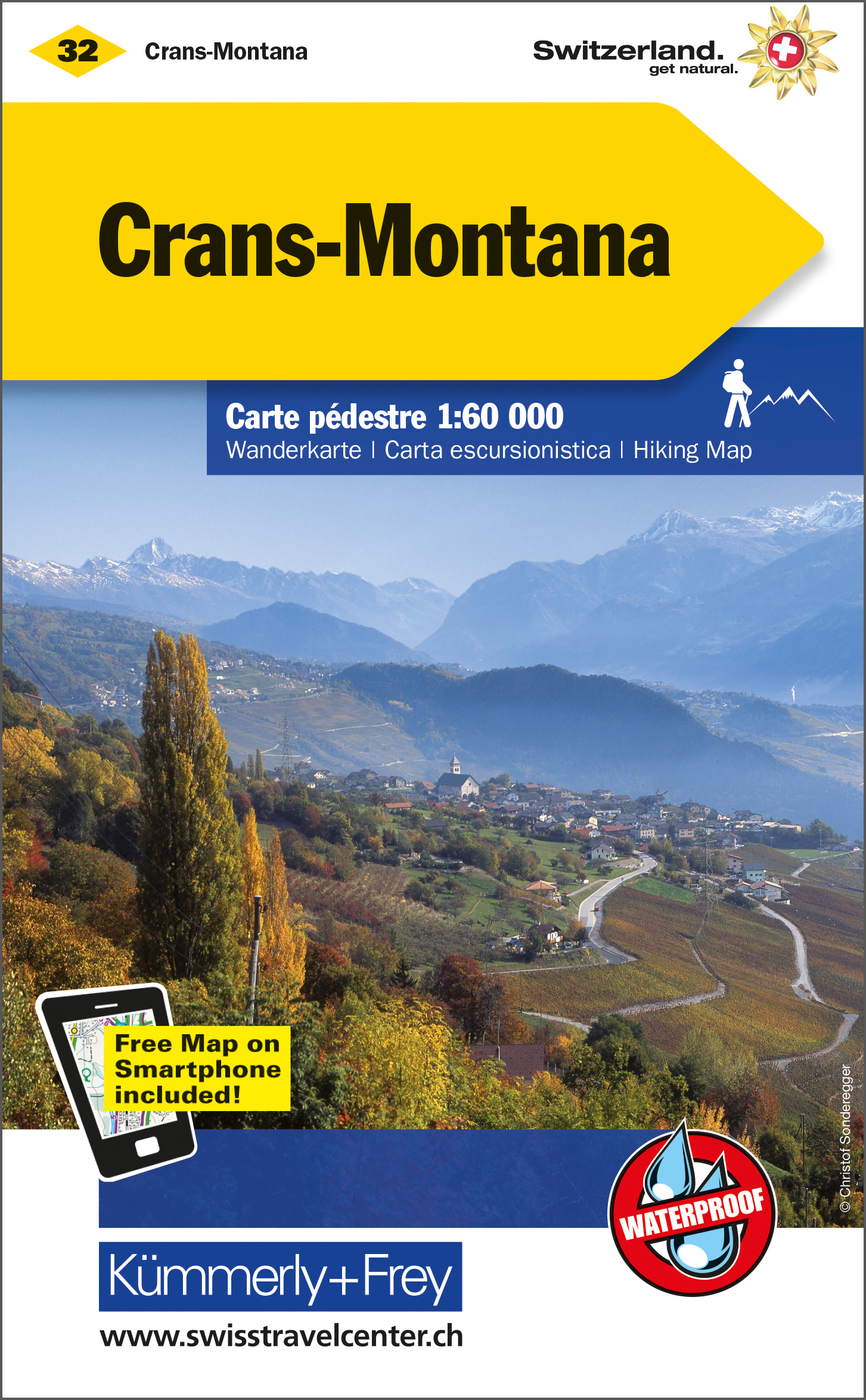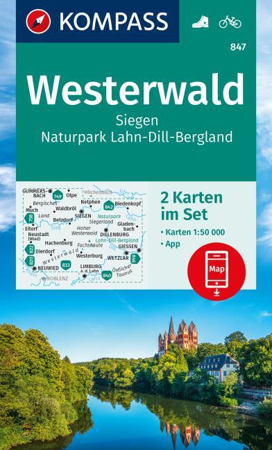
<div> Goede 2-delige wandelkaartenset met vrijwel alle topografische details als hoogtelijnen, vegetatie, schaduwtekening maar ook de ingetekende wandelroutes en in veel gevallen ook fietsroutes (MTB). Gevaarlijke routes worden als zodanig weergegeven met een bepaalde markering. Berghutten en campings zijn goed terug te vinden op deze kaarten.</div> <div> </div> <div> Daarnaast staan de toeristische bezienswaardigheden met symbolen vermeld. Kleurgebruik kan soms vrij fel overkomen, daardoor oogt deze detailkaart wellicht wat druk, maar het blijft een goed leesbare kaart. Sommige kaarten zijn geplastificeerd, maar helaas niet allemaal. De graden staan aan de zijkanten van de kaart, daardoor te gebruiken voor GPS.</div> <div> </div> <div> <strong>Dorpen en steden op de kaart</strong></div> <div> Gummersbach, Olpe, Netphen, Biedekopf, Much, Waldbröl, Siegen, Gladenbach, Dillenburg, Giessen, Eitorf, Neustadt/Wied, Hachenburg, Dierdorf, Westerburg, Neuwied, Wetzlar, Limburg, Sieg, Dill, Lahn, Fuchskaute</div>
€15,95
Bekijk product
<div> <div> Goede 2-delige wandelkaartenset met vrijwel alle topografische details als hoogtelijnen, vegetatie, schaduwtekening maar ook de ingetekende wandelroutes en in veel gevallen ook fietsroutes (MTB). Gevaarlijke routes worden als zodanig weergegeven met een bepaalde markering. Berghutten en campings zijn goed terug te vinden op deze kaarten.</div> <div> </div> <div> Daarnaast staan de toeristische bezienswaardigheden met symbolen vermeld. Kleurgebruik kan soms vrij fel overkomen, daardoor oogt deze detailkaart wellicht wat druk, maar het blijft een goed leesbare kaart. Sommige kaarten zijn geplastificeerd, maar helaas niet allemaal. De graden staan aan de zijkanten van de kaart, daardoor te gebruiken voor GPS.</div> </div> <div> </div>
€11,95
Bekijk product
<div> <span style="color: rgb(0, 0, 0); font-family: 'Helvetica Neue', Helvetica, sans-serif, Arial; line-height: 16px;">Gedetailleerde wegenkaart en wandelkaart met alle kleine wegen, wandelpaden, hoogtelijnen en toeristische informatie aangegeven. Alle tekst is tweetalig in Engels en Grieks en de waterproof kaart is geschikt voor gebruik met GPS.</span></div> <div> </div> <div> <span style="color: rgb(0, 0, 0); font-family: 'Helvetica Neue', Helvetica, sans-serif, Arial; line-height: 16px;">This is a detailled map of Santorini. Features:</span></div> <ul> <li> It is waterproof and rip-proof. You can fold and unfold it a thousand times, fold it in irregular ways, dunk it in the sea or leave it out in the rain. This map is indestructible! </li> <li> It indicates the boundaries of NATURA 2000 areas so that you will know which parts of the island are of special environmental interest and beauty – thus you can enjoy traveling through them, but also take care to protect them. </li> <li> The length of all trails is measured in kilometers, so you can estimate the duration of your hike no matter which trail / road combination you follow. </li> <li> It features detailed descriptions of 2 trails on the back, including their total length in kilometers and the duration of the hike, and the wineries of Santorini, hence it is the ideal map for those interested in wine tourism. </li> <li> It features detailed, up-to-date maps of Oia, Fira and Imerovigli indicating the bars, restaurants, hotels and other useful information. Moreover, it includes the climbing crags of Santorini for the first time ever. There is detailed information about climbing on Santorini on the back of the map. </li> </ul> <div> </div> <div> NOTE 1: An error in pre-printing processing resulted in a slight magnification of the map (approximately 5%). Thus, the scale of the map is not 1:25.000 but 1:24.390 and the coordinate values on the right and bottom of the map are poorly printed. Special mention of this problem is also made on the map itself. </div> <div> </div> <div> NOTE 2: Due to extreme weather conditions during the planned expedition, TERRAIN’s cartographic vessel was unable to map the coastline of Santorini, so in this first edition the beaches of Santorini were recorded by cartographers in the ground team. This means that some small beaches not accessible by road or trail may be missing from the map, and the type of seabed in front of these beaches is not recorded.</div>
€11,95
Bekijk product
<p> Gedetailleerde wegenkaart en wandelkaart met alle kleine wegen, wandelpaden, hoogtelijnen en toeristische informatie aangegeven. Alle tekst is tweetalig in Engels en Grieks en de waterproof kaart is geschikt voor gebruik met GPS.</p> <p> De uitgever: THIS IS THE BEST MAP OF ALONNISOS BECAUSE:</p> <p> • It is the only GIS map of Alonnisos made with data collected 100% through field survey.</p> <p> • It shows the entire trail network of Alonnisos, with impeccable accuracy. All trails are measured in kilometers so you can estimate the duration of your hike. On the back side 16 of the island’s hikes are presented in detail, also distinctly labeled on the map so you can easily locate them.</p> <p> • It includes maps of the neighboring islands of Peristera and Kyra Panaghia, with fully mapped coastline (all beaches are shown).</p> <p> • It includes a detailed town plan of Patitiri, in the scale of 1:5.500 as well as a map of the National Marine Park region.</p> <p> • It is printed on Polyart plastic “paper”, making it totally waterproof and rip-proof. You can fold it and unfold it a hundred times, fold it in irregular ways, dunk it in the sea or leave it out in the rain. This map is indestructible!</p> <p> • The island’s entire coastline is mapped for the first time with TERRAIN’s specially equipped and staffed cartographic vessel. This means that you can locate all beaches of the island, down to the tiniest cove! In fact, the special features of every single beach are recorded: whether it is sandy or pebbled, whether it features natural tree shade, water, a beach bar or organized water sports, whether the seabed in front of the beach is sandy or rocky (so that you will know where to anchor).</p> <p> • Recommended mountain-bike routes are shown.</p> <p> • It indicates the boundaries of NATURA 2000 areas so that you will know which parts of the island are of special environmental interest and beauty – thus you can enjoy traveling through them, but also take care to protect them.</p> <p> • Hotel sites are indicated, so you can easily locate them.</p> <p> • The reverse side features an illustrated mini travel guide, with information on the island’s myths and history, geography and natural environment, sights and major attractions.</p>
€11,95
Bekijk product