
Beantwoord enkele vragen, en binnen seconden geeft AI je een persoonlijk aankoopadvies op maat.
Beantwoord enkele vragen, en binnen seconden geeft AI je een persoonlijk aankoopadvies op maat.
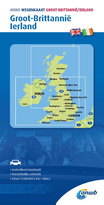
<div> De ANWB heeft een grote serie wegenkaarten van de belangrijkste landen en streken. Het zijn echte overzichtskaarten van vaak een wat groter gebied. Deze keuze zorgt er voor dat de schaal vrij grof is en bepaalde details zijn weggelaten. De kleurstelling is een beetje flets waardoor je niet altijd even makkelijk onderscheid kan maken tussen verschillende landschappen of natuurlijke aspecten. </div> <div> Ook het register ontbreekt. Het grote voordeel is vaak dat het gebied op de kaart overeenkomt met de vraag van klanten. Voor het plannen van een vakantie een prima kaart!</div> <div> </div> <div> Vergeleken met andere uitgevers van kaarten als Michelin, Freytag und Berndt of Reise KnowHow heeft de ANWB duidelijke keuzes gemaakt en gekozen voor een echte overzichtskaart. </div> <div> </div> <div> MET DE ANWB WEGENKAART, WEET JE WAAR JE STAAT! ANWB wegenkaarten zijn een begrip in het land. Dat laten de verkoopcijfers ook zien. Afgelopen decennia zijn meer dan 10 miljoen kaarten over de toonbank gegaan. De wegenkaarten zijn allemaal vernieuwd, met dikker karton voor de omslagen en papier dat minder makkelijk scheurt, zodat ze veelvuldig in- en uitgevouwen kunnen worden. Ze bieden een duidelijker overzicht van het wegennet en zijn nu nog compacter en handzamer. </div>
€12,99
Bekijk product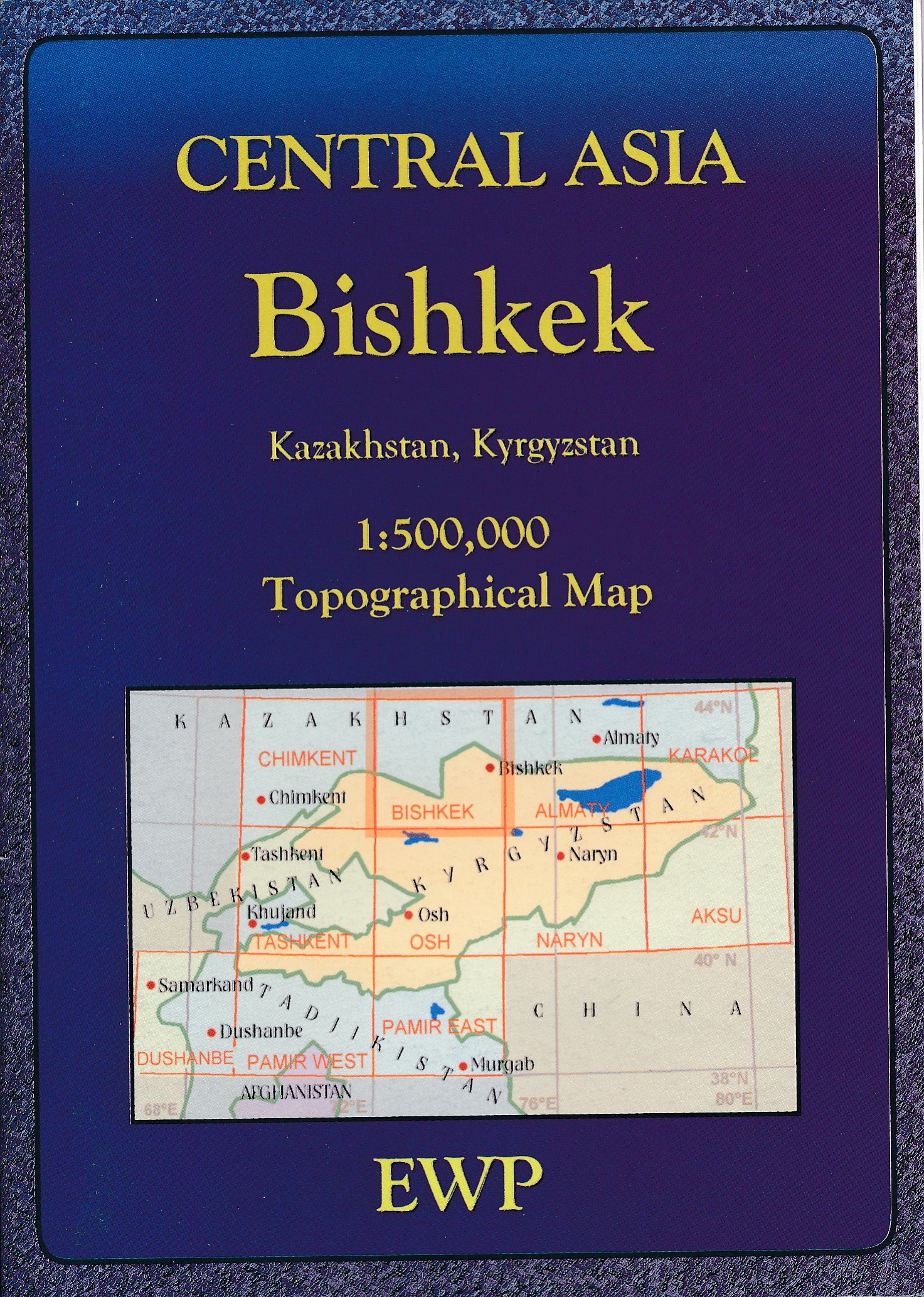
<p> Mooie, gedetailleerde topografische kaart van het grensgebied van Kazachstan en Kirgizië. Met hoogtelijnen en reliëfkleuren, uitgebreide legenda en veel detail. Inclusief korte geografische woordenlijst<span style="color: rgb(0, 0, 0); font-family: verdana, arial, sans-serif; font-size: 11px;">.</span></p> <p> </p>
€19,95
Bekijk product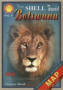
<p> Kleurrijke toeristenkaart van Botswana met wegennetwerk, bezienswaardigheden, parken, bezinestations etc. ingetekend. Met deelkaartjes van de nationale- en wildparken. </p> <p> The Shell Tourist Map of Botswana plus 19 enlarged maps of tourist areas and over 300 GPS co-ordinats</p>
€11,95
Bekijk product
<p> Goede wegenkaart van een deel van Griekenland. Waar beschikbaar worden hotels en campings getoond en met symbolen worden allerhande toeristische symbolen aangeduid als historische plaatsen, kloosters, museas etc. Tweetalig. Op elke kaart staat van de belangrijkste steden een centrumkaart en er is een behoorlijk uitgebreid register (wel kleine letters!) Kleurgebruik is duidelijk, maar een beetje flets, waardoor hoogteverschillen niet echt goed uitkomen. </p> <p> </p>
€10,25
Bekijk product
<p> Deze kaart is zuiver gericht op de provincie als in de titel. Gebieden naast de kaart worden zonder kleur weergegeven. Ideale kaart als het gaat om het onderscheid in topografische details als hoogte, nationale parken, vegetatie en plaatsen. Met schaduwrelief wordt hoogte goed zichtbaar. Zeker geschikt voor fietsers, al heb je er soms wel veel nodig. Nadeel is het feit dat deze kaarten niet altijd even goed up-to-date zijn. Het komt soms wel voor dat bepaalde wegen inmiddels veel groter zijn geworden dan ingetekend op de kaart. Maar dan gaat het vooral om de grotere wegen: voor kleinere details is het een prima kaart.</p> <p> One of the titles in a series of contoured road maps from Spain's civilian survey organisation, each covering one administrative province, excellent in presenting the country’s topography and locations of its many national and natural parks. The maps have contours at 100-metre intervals enhanced by relief shading, plus spot heights. Additional colouring is used to indicate various types of vegetation. Boundaries of national/natural parks are highlighted. Road network includes minor local roads and tracks, and motorways distinguish between free and toll routes. Railways show high speed, double, and single track lines. Unless indicated to the contrary in the individual descriptions, the maps have UTM grid, plus latitude and longitude margin ticks at 15' intervals, and an index of place names on the reverse. The legend is in Spanish only. Unlike in the older versions of this series, on each title all the information continues outside the provincial boundary, but without the relief shading and vegetation colouring.</p> <p> <strong>Plaatsen op de kaart</strong></p> <div> Zamora</div> <div> Benavente</div> <div> Toro</div> <div> Villamayor de Treviño</div> <div> Olmedo</div> <div> Valle de San Lorenzo</div> <div> San Martín de Valderaduey</div> <div> San Román de la Cuba</div> <div> Puebla de Sanabria</div> <div> Vilvestre</div>
€9,95
Bekijk product
<p> Deze kaart is zuiver gericht op de provincie als in de titel. Gebieden naast de kaart worden zonder kleur weergegeven. Ideale kaart als het gaat om het onderscheid in topografische details als hoogte, nationale parken, vegetatie en plaatsen. Met schaduwrelief wordt hoogte goed zichtbaar. Zeker geschikt voor fietsers, al heb je er soms wel veel nodig.</p> <p> Nadeel is het feit dat deze kaarten niet altijd even goed up-to-date zijn. Het komt soms wel voor dat bepaalde wegen inmiddels veel groter zijn geworden dan ingetekend op de kaart. Maar dan gaat het vooral om de grotere wegen: voor kleinere details is het een prima kaart.</p> <p> One of the titles in a series of contoured road maps from Spain's civilian survey organisation, each covering one administrative province, excellent in presenting the country’s topography and locations of its many national and natural parks. The maps have contours at 100-metre intervals enhanced by relief shading, plus spot heights. Additional colouring is used to indicate various types of vegetation. Boundaries of national/natural parks are highlighted. Road network includes minor local roads and tracks, and motorways distinguish between free and toll routes. Railways show high speed, double, and single track lines. Unless indicated to the contrary in the individual descriptions, the maps have UTM grid, plus latitude and longitude margin ticks at 15' intervals, and an index of place names on the reverse. The legend is in Spanish only. Unlike in the older versions of this series, on each title all the information continues outside the provincial boundary, but without the relief shading and vegetation colouring.</p>
€9,95
Bekijk product
<p> Prima wegenkaart - landkaart van Tanzania, nu met een nieuwe schaal van 1:1.300.000.</p> <p> Met uitgebreide legenda zodat campings, tankstations, bezienswaardigheden en dergelijke staan aangegeven.</p> <div> Explore Tanzania with this Freytag & Berndt road map. The best way to plan your trip, prepare your itinerary, and to travel independently in this country.</div> <div> </div> <div> This map includes an index on the back, and touristic information on this map includes accommdation, international airports, museums, places of particular interest, antique sites and river/canal systems.</div>
€14,95
Bekijk product
<p> Uitstekende wegenkaart van Rheinland Pfalz en Saarland in Duitsland met schaal 1:200.000.</p> <div> Goede wegenkaart van een deel van Duitsland. Helder kleurgebruik, tweezijdig waardoor meer gedetailleerd met veel toeristische informatie. Met register.</div> <div> </div> <div> The map highlights picturesque towns and national parks, with a range of symbols marking campsites, youth hostels, museums, spas, various landmarks and places of interest. As with all Freytag & Berndt maps the cartography is clear and detailed with the topography shown by relief shading with plenty of spot heights.</div> <div> </div> <div> A localities index with postcodes is in a small booklet attached to the cover and the legend is in various languages including English</div>
€14,95
Bekijk product
<p> freytag & berndt Autokarten sind für viele Länder und Regionen weltweit erhältlich. Neben der übersichtlichen Gestaltung verfügen die Straßenkarten über zahlreiche Zusatzinformationen wie z.B. Straßenbeschaffenheit, Sehenswürdigkeiten, Campingplätze und diverse Innenstadtpläne. Mit dem umfangreichen Ortsregister gelingt zudem eine rasche Orientierung. Cityplan; Ortsregister; Nationalparks; Sehenswürdigkeiten</p>
€14,95
Bekijk product
<p> <span style="color: rgb(0, 0, 0); font-family: 'Helvetica Neue', Helvetica, sans-serif, Arial;">Wegenkaart van Noordwest India met vermelding van veel bezienswaardigheden, nationale parken en attrakties. Watervast en scheurvast.</span></p> <div> National Geographic's India Northwest Adventure Map is designed to meet the unique needs of adventure travelers with its durability and detailed, accurate information. The map includes the locations of thousands of cities and towns with a user-friendly index, as well as a clearly marked road network complete with distances and designations for highways, major routes and secondary roads.</div> <div> </div> <div> The India Northwest Adventure Map differs from a traditional road map for it includes hundreds of points of interest that highlight diverse and unique destinations in the region. The map features UNESCO World Heritage sites, national parks, archaeological sites, wildlife sanctuaries, Hindu, Buddhist and Sikh temples, forts, palaces and other points of interest, making it an invaluable resource to travelers hoping to experience all the history and culture India has to offer. Additional travel aids include the location of airports, harbors, and ferry routes.</div> <div> </div> <div> The front side of the map covers India’s far northwestern corner, including the Kashmir region and the great Himalaya range, as well as the states Haryana, Himachal Pradesh, Punjab, Rajasthan, Uttarakhand, Uttar Pradesh, and the National Capital Territory. The reverse includes coverage of the border area with Pakistan to the west, the southern part of Rajasthan and Uttar Pradesh, as well as Madhta Pradesh and the cities of Bhopal, Gujarat and Ahmadabad to the Kathiawar Peninsula. The India Northwest Adventure Map is printed in the United States on a durable synthetic paper, making it waterproof, tear-resistant and tough—capable of withstanding the rigors of international travel.</div> <div> </div> <div> Key Features:</div> <ul> <li> Waterproof and tear-resistant</li> <li> Detailed topography complete with activity symbols, ideal for exploring the country</li> <li> Hundreds of points of interest including UNESCO World Heritage sites, archaeological sites, Hindu and Buddhist temples</li> <li> Thousands of place names</li> <li> </li> <li> Important travel aids including airports, ferry routes, and rail lines</li> </ul>
€17,50
Bekijk product