
Beantwoord enkele vragen, en binnen seconden geeft AI je een persoonlijk aankoopadvies op maat.
Beantwoord enkele vragen, en binnen seconden geeft AI je een persoonlijk aankoopadvies op maat.
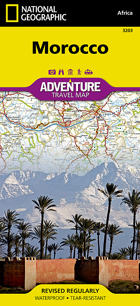
<p> <span style="color: rgb(0, 0, 0); font-family: 'Helvetica Neue', Helvetica, sans-serif, Arial; line-height: 16.363636016845703px;">Wegenkaart van Marokko met vermelding van veel bezienswaardigheden, nationale parken en attrakties. Watervast en scheurvast. Juist door deze vermeldingen onderscheidt de kaart zich van andere wegenkaarten.</span></p> <div> National Geographic's Morocco Adventure Map is designed to meet the unique needs of adventure travelers—detailed, durable, and accurate. Morocco includes the locations of thousands of cities and towns with an index for easily locating them, plus a clearly marked road network complete with distances and designations for motorways, dual carriageways, major roadways, and more. Transportation within and beyond the country is made easier with the location of airports, airfields, railroads, ferry routes, river crossings, lighthouses, harbors, border crossings, and petrol stations. What sets National Geographic Adventure Maps apart from traditional road maps are the hundreds of points of interest that highlight the diverse, unique, and exotic destinations within Morocco. In addition to typical sites of interest such as World Heritage sites, national parks, zoos, mosques, churches, and archeological sites, this map includes Morocco’s many casbahs, and marabouts, making it invaluable to travelers hoping to experience the country’s rich history and culture. Beaches, yachting harbors, and areas popular for fishing and surfing dot Morocco’s extensive Mediterranean and Atlantic coastlines. Other recreational destinations such as ski resorts, golf courses, spas, caves, and oases are included as well.</div> <div> </div> <div> Morocco’s northern half is shown on the front side of the map and includes the cities of Tangier, Tetouan, Fez, Rabat, Casablanca, and Marrakesh. The reverse side of the map covers the southern portion of the country and includes a large inset map of Western Sahara. Formerly Spanish Sahara, Western Sahara is a territory administered by Morocco, though the United Nations does not recognize this annexation and the territory remains in dispute.</div> <div> </div> <p> </p> <div> Popular places included on the map: Tangier, Tetouan, Al Hoceima National Park, Fez, Rabat, Ifrane National Park, Casablanca, Marrakesh, Atlas Mountains, Safi, Souss-Massa National Park, Essaouira, Toubkal National Park, Errachidia, Tazekka National Park, Agadir.</div>
€17,50
Bekijk product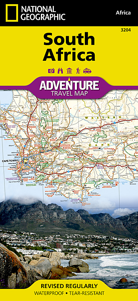
<p> Wegenkaart van Zuid Afrika met vermelding van veel bezienswaardigheden, nationale parken en attrakties. Watervast en scheurvast. Juist door deze vermeldingen onderscheidt de kaart zich van andere wegenkaarten.</p> <div> National Geographic’s South Africa Adventure Map is designed to meet the unique needs of adventure travelers—detailed, durable, and accurate. It includes the locations of thousands of major cities and towns with an index for easily locating them, plus a clearly marked road network complete with distances and designations for major highways, limited access highways, and more. Both paved and unpaved roads, tracks, and trails are marked for those adventurers who wish to explore less traveled routes.</div> <div> </div> <div> What sets National Geographic Adventure Maps apart from traditional road maps are the hundreds of points-of-interest that highlight the diverse, unique, and exotic destinations within South Africa including national parks and reserves, sanctuaries, World Heritage sites, archeological sites, museums, and important travel aids like airports, airfields, rail lines, ferry routes, and lighthouses.</div> <div> </div> <div> The west side of the South Africa map includes the Northern Cape, Western Cape, Eastern Cape, and portions of the North West and Free State provinces. Diverse points of interest are featured including the Western Cape’s wine regions and spas. Along the coast between Cape Town, the legislative capital, and Port Elizabeth, areas for whale watching and shark-cage diving are noted. Johannesburg and neighboring city Pretoria (administrative capital) are included on the east side of the map along with Bloemfontein (judicial capital) and the coastal city of Durban. South Africa’s many national parks, reserves, and wildlife sanctuaries are clearly marked, as are other natural points of interest and scenic viewpoints. Dozens of beaches are noted from the Sunshine Coast to the North Coast for travelers wishing to soak up some sun.</div> <div> </div> <div> Coverage highlights: Kruger Park, Table Mountain, The Garden Route, Real de Catorce, Soweto, Cradle of Humankind, Sterkfotein Caves, and Blyde River Canyon.</div>
€17,50
Bekijk product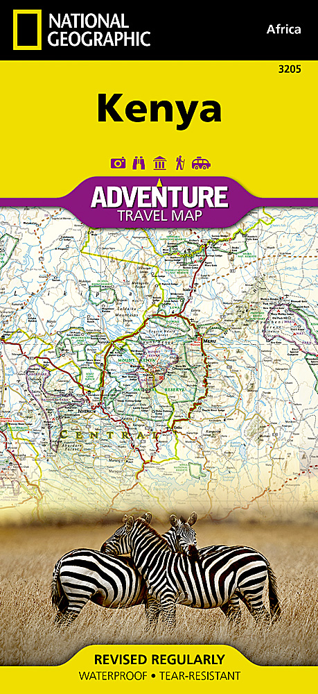
<div> Wegenkaart van Kenia met vermelding van veel bezienswaardigheden, nationale parken en attrakties. Watervast en scheurvast. Juist door deze vermeldingen onderscheidt de kaart zich van andere wegenkaarten. <div> </div> </div> <div> National Geographic's Kenya Adventure Map is designed to meet the unique needs of adventure travelers with its durability and accurate information. This folded map provides global travelers with the perfect combination of detail and perspective, highlighting hundreds of points of interest and the diverse and unique destinations within the country. The map includes the locations of cities and towns with a user-friendly index, plus a clearly marked road network complete with distances and designations for major highways, main roads, and tracks and trails for those seeking to explore more remote regions.</div> <div> </div> <div> The front side of the Kenya map details the southern region of the country, from The Indian Ocean to the east, to the bordering country of Tanzania to the southwest. The reverse side of the map details the northern region, showing the bordering country of Ethiopia to the north, Somalia to the east, and Uganda to the west.</div> <div> </div> <div> Key Features:</div> <ul> <li> Waterproof and tear-resistant</li> <li> Accurate topography/terrain with a clearly labeled road network</li> <li> Hundreds of points of interest, including the locations parks and nature reserves, protected lands, historical and cultural attractions</li> <li> Thousands of place names including towns and natural features; detailed place names index</li> <li> Important travel networks including airports, lighthouses, ferry routes, and rail lines</li> </ul>
€17,50
Bekijk product
<p> <span style="color: rgb(0, 0, 0); font-family: 'Helvetica Neue', Helvetica, sans-serif, Arial; line-height: 16.363636016845703px;">Wegenkaart van Botswana met vermelding van veel bezienswaardigheden, nationale parken en attrakties. Watervast en scheurvast. Juist door deze vermeldingen onderscheidt de kaart zich van andere wegenkaarten.</span></p> <div> National Geographic's Botswana Adventure Map is designed to meet the unique needs of adventure travelers with its durability and accurate information. This folded map provides global travelers with the perfect combination of detail and perspective, highlighting hundreds of points of interest and the diverse and unique destinations within the country. The map includes the locations of cities and towns with a user-friendly index, plus a clearly marked road network complete with distances and designations for major highways, main roads, and tracks and trails for those seeking to explore more remote regions.</div> <div> </div> <div> The front side of the Botswana map details the northern region of the country, from Namibia to the north and west, to the bordering country of Zimbabwe to the east. The reverse side of the map details the southern region, showing the bordering country of Zimbabwe to the east, and South Africa to the south.</div> <div> </div> <div> Key Features:</div> <ul> <li> Waterproof and tear-resistant</li> <li> Accurate topography/terrain with a clearly labeled road network</li> <li> Hundreds of points of interest, including the locations parks and nature reserves, protected lands, historical and cultural attractions</li> <li> Thousands of place names including towns and natural features; detailed place names index</li> <li> <span style="font-size: 12px;">Important travel networks including airports, lighthouses, ferry routes, and rail lines</span></li> </ul>
€17,50
Bekijk product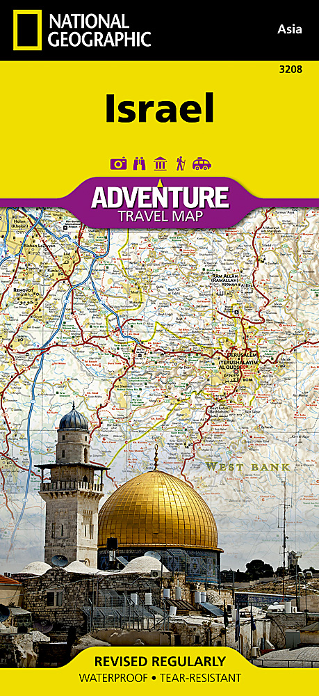
<p> <span style="color: rgb(0, 0, 0); font-family: 'Helvetica Neue', Helvetica, sans-serif, Arial; line-height: 16.363636016845703px;">Wegenkaart van Isreal met vermelding van veel bezienswaardigheden, nationale parken en attrakties. Watervast en scheurvast. Juist door deze vermeldingen onderscheidt de kaart zich van andere wegenkaarten.</span></p> <div> National Geographic's Israel Adventure Map is designed to meet the unique needs of adventure travelers with its durability and accurate information. This folded map provides global travelers with the perfect combination of detail and perspective, highlighting hundreds of points of interest and the diverse and unique destinations within the country.</div> <div> </div> <div> The map includes the locations of cities and towns with a user-friendly index, plus a clearly marked road network complete with distances and designations for major highways, main roads, and tracks and trails for those seeking to explore more remote regions. The front side of the Israel map details the northern region of the country, from its border with Lebanon to the north, to Syria and Jordan to the east and the Mediterranean Sea to the west. The reverse side of the map details Israel’s southern region, bordering Jordan to the east, Egypt and the Mediterranean Sea to the west, and the Gulf of Aqaba to the southernmost point. Every Adventure Map is printed on durable synthetic paper, making them waterproof, tear-resistant and tough—capable of withstanding the rigors of international travel.</div> <div> </div> <div> Key Features:</div> <ul> <li> Waterproof and tear-resistant</li> <li> Detailed interpretive information and local travel tips</li> <li> Detailed topography complete with activity symbols, ideal for exploring the country</li> <li> City overview maps</li> <li> Hundreds of points of interest, including the location of World Heritage sites, national parks and nature reserves, aboriginal settlements and protected lands, mines, archeological sites, wildlife parks and more</li> <li> Thousands of place names</li> <li> Important travel aids including airports, lighthouses, ferry routes and rail lines</li> <li> Developed in cooperation with local agencies</li> <li> Updated regularly to ensure accuracy</li> <li> </li> </ul> <div> </div>
€17,50
Bekijk product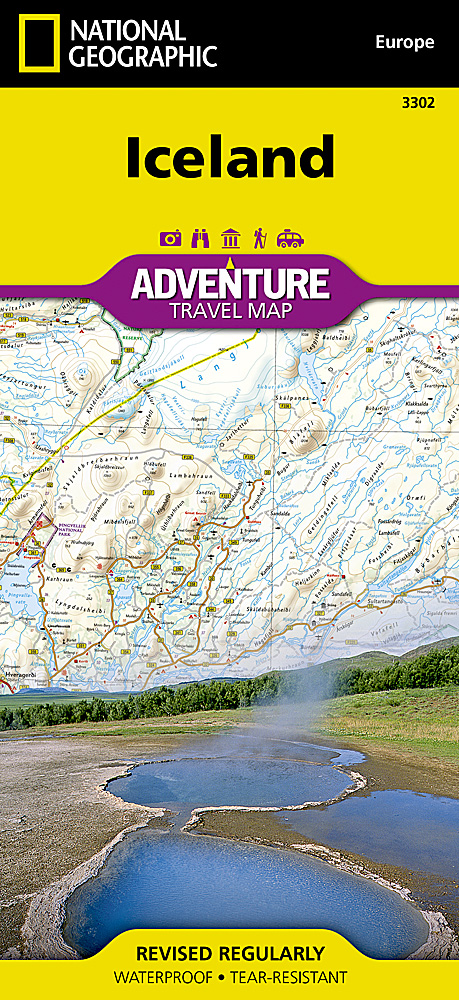
<p> Wegenkaart van IJsland met vermelding van veel bezienswaardigheden, nationale parken en attrakties. Watervast en scheurvast. Juist door deze vermeldingen onderscheidt de kaart zich van andere wegenkaarten.</p> <div> National Geographic's Iceland Adventure Map is designed to meet the unique needs of adventure travelers—detailed, durable, and accurate. Iceland includes the locations of thousands of cities and towns with an index for easily locating them, plus a clearly marked road network complete with distances and designations for expressways, motorways, and more. Transportation within and beyond the country is made easier with the locations of airports, airfields, railroads, ferry routes, and lighthouses. What sets National Geographic Adventure Maps apart from traditional road maps are the hundreds of points of interest that highlight the diverse and unique destinations within Iceland. Outdoor activities abound on the island and activity symbols note popular locations to ski, golf, camp, fish, and swim. Travelers will find plenty to explore in Iceland’s cities as well, including World Heritage sites, museums, churches, and other points of interest.</div> <div> </div> <div> Iceland’s western half is shown on the front side of the map including the cities of Reykjavik, Hafnarfjordur, Kopavogur, Gardabaer, Mossfellsbaer, Keflavik, Borgarnes, Stykkisholmur, and Siglufjordur. The reverse side of the map covers the eastern portion of the country showing the cities of Akureyri, Egilsstadir, Eskifjordur, Neskaupstadur, Husavik, and Hofn.</div> <div> </div> <div> Popular places included on the map</div> <div> Reykjavik, Kopavogur, Hafnarfjordur, Gardabaer, Mossfellsbaer, Vatnajokull National Park, Akureyri, Thingvellir National Park, Vatnsfjordur Nature Reserve, Egilsstadir, Hofn, Thjorsarver Nature Reserve, Geitland Nature Reserve, Blue Lagoon Thermal Spa, Eskifjrdur, Reykjanesfolkvangur Nature Reserve, Gullfoss & Geysir, Skaftafell National Park, Neskaupstadur, Husavik.</div> <div> </div>
€17,50
Bekijk product
<div> <span style="color: rgb(0, 0, 0); font-family: 'Helvetica Neue', Helvetica, sans-serif, Arial; line-height: 16.363636016845703px;">Wegenkaart van Itali</span><span style="font-size: 12px;">ë </span><span style="color: rgb(0, 0, 0); font-family: 'Helvetica Neue', Helvetica, sans-serif, Arial; line-height: 16.363636016845703px; font-size: 12px;">met vermelding van veel bezienswaardigheden, nationale parken en attrakties. Watervast en scheurvast. Juist door deze vermeldingen onderscheidt de kaart zich van andere wegenkaarten.</span></div> <div> </div> <div> National Geographic's Italy Adventure Map is designed to meet the unique needs of adventure travelers—detailed, durable, and accurate. Italy includes the locations of thousands of major cities and towns with an index for easily locating them, plus a clearly marked road network complete with distances and designations for expressways, motorways, and more.</div> <div> </div> <div> What sets National Geographic Adventure Maps apart from traditional road maps are the hundreds of points of interest that highlight the diverse and unique destinations within Italy. National parks, World Heritage sites, caves, scenic viewpoints, archeological sites, castles, palaces, churches, monasteries, and museums are included, making it invaluable to travelers hoping to experience all the history, art, and culture this amazing country has to offer. Additional aids including the location of airports, lighthouses, ferry routes, and border crossings make travel within and beyond the country easier.</div> <div> </div> <div> The front side of the Italy map shows the northern half of the country from its borders with France, Switzerland, Austria, and Slovenia to its capital, Rome, and includes the provinces of Aosta Valley, Piedmont, Lombardy, Trentino-Alto Adige, Friuli-Venezia Giulia, Veneto, Emilia-Romagna, Liguria, Tuscany, Marche, Umbria, Lazio, Abruzzo, and Molise. The southern half of the country including the Mediterranean islands of Sicily and Sardinia, and the provinces of Campania, Apulia, Basilicata, and Calabria are covered on the reverse side of the map.</div>
€17,50
Bekijk product
<p> <span style="color: rgb(0, 0, 0); font-family: 'Helvetica Neue', Helvetica, sans-serif, Arial; line-height: 16.363636016845703px;">Wegenkaart van Toscane</span><span style="color: rgb(0, 0, 0); font-family: 'Helvetica Neue', Helvetica, sans-serif, Arial; font-size: 12px;"> </span><span style="color: rgb(0, 0, 0); font-family: 'Helvetica Neue', Helvetica, sans-serif, Arial; font-size: 12px; line-height: 16.363636016845703px;">met vermelding van veel bezienswaardigheden, nationale parken en attrakties. Watervast en scheurvast. Juist door deze vermeldingen onderscheidt de kaart zich van andere wegenkaarten.</span></p> <div> National Geographic's Tuscany Adventure Map is designed to meet the unique needs of adventure travelers—detailed, durable, and accurate. Tuscany includes the locations of thousands of cities and towns with an index for easily locating them, plus a clearly marked road network complete with distances and designations for expressways, motorways, scenic routes, and more.</div> <div> </div> <div> What sets National Geographic Adventure Maps apart from traditional road maps are the hundreds of points of interest that highlight the diverse and unique destinations within Tuscany. Archeological sites, menhirs and other sites of interest from monuments, palaces, and castles to churches, chapels, and monasteries are noted making this map indispensable for travelers seeking to explore the region’s rich history. Users will find a variety of helpful travel aids on our map as well, including the location of airports, airfields, railroads, lighthouses, ferry routes, harbors, anchorages and petrol stations.</div> <div> </div> <p> </p> <div> Tuscany’s coastline and the western portion of the province are shown on the front side of the map including the cities of Pisa and Livorno. An inset map of the Arcipelago Toscano National Park provides greater detail of the islands. The reverse side of the map covers the eastern portion of the province and shows the cities of Florence, Grosseto, Siena, and Arezzo. Lake Tresimeno in neighboring Umbria is also included.</div>
€17,50
Bekijk product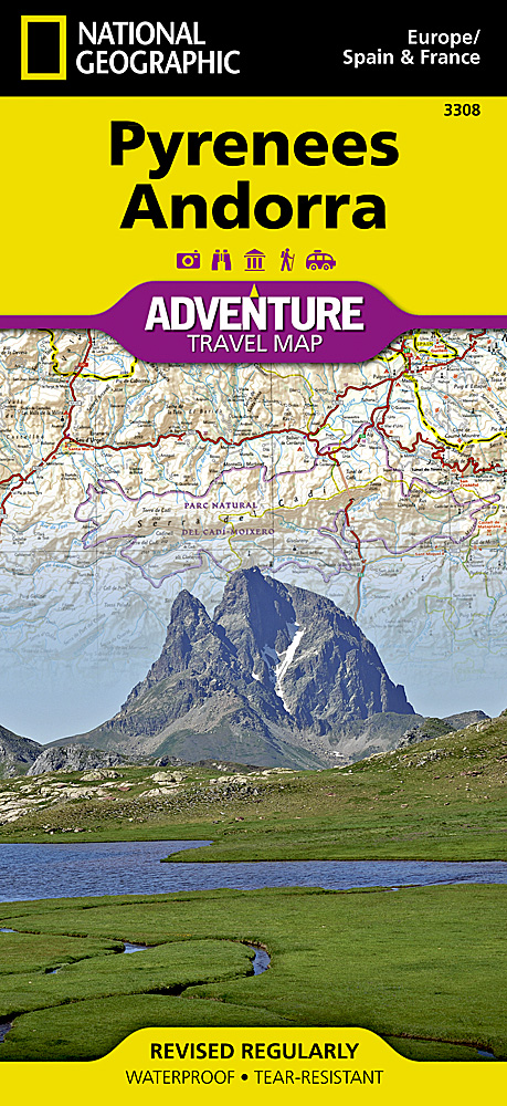
<p> <span style="color: rgb(0, 0, 0); font-family: 'Helvetica Neue', Helvetica, sans-serif, Arial; line-height: 16.363636016845703px;">Wegenkaart van de </span>Pyreneeën<span style="color: rgb(0, 0, 0); font-family: 'Helvetica Neue', Helvetica, sans-serif, Arial; line-height: 16.363636016845703px;"> en Andorra </span><span style="color: rgb(0, 0, 0); font-family: 'Helvetica Neue', Helvetica, sans-serif, Arial; font-size: 12px; line-height: 16.363636016845703px;">met vermelding van veel bezienswaardigheden, nationale parken en attrakties. Watervast en scheurvast. Juist door deze vermeldingen onderscheidt de kaart zich van andere wegenkaarten.</span></p> <div> National Geographic's Pyrenees and Andorra Adventure Map is designed to meet the unique needs of adventure travelers—detailed, durable, and accurate. Pyrenees/Andorra includes the locations of thousands of major cities and towns with an index for easily locating them, plus a clearly marked road network complete with distances and designations for expressways, motorways, scenic routes, and more.</div> <div> </div> <div> What sets National Geographic AdventureMaps apart from traditional road maps are the hundreds of points of interest that highlight the diverse and unique destinations within the Pyrenees and Andorra. National parks, World Heritage sites, scenic viewpoints, antiquity sites, museums, places of worship, zoos, castles and more are included, making it invaluable to travelers hoping to experience all the history, art, and culture the region has to offer. Beaches and yachting harbors dot Spain and France’s Mediterranean coastlines while the location of golf courses, camping sites, waterfalls, caves, and ski areas make it easy to enjoy the region’s abundant outdoor activities. Users will find a variety of helpful travel aids on our map as well, including the location of airports, airfields, railroads, lighthouses, and petrol stations.</div> <div> </div> <p> </p> <div> The front side of the Pyrenees/Andorra map shows the country of Andorra and the eastern half of the Pyrenees including the cities of Narbonne, Carcassone, Pamiers, St-Gaudens, St-Girons, Perpignan in France, and Balaguer, Manresa, and Figueres in Spain. The reverse side of the map stretches from the city of Biarritz on the Bay of Biscay eastward to include Pamplona and Huesca, Spain, and Pau, Tarbes, and the famed pilgrimage site of Lourdes, France.</div>
€17,50
Bekijk product
<div> Wegenkaart van Sardinië, Italië met vermelding van veel bezienswaardigheden, nationale parken en attrakties. Watervast en scheurvast. Juist door deze vermeldingen onderscheidt de kaart zich van andere wegenkaarten.</div> <div> </div> <div> Sardinia Adventure Map is designed to meet the unique needs of adventure travelers—detailed, durable, and accurate. Sicily includes the locations of thousands of cities and towns with an index for easily locating them, plus a clearly marked road network complete with distances and designations for highways, major roadways, and more. What sets National Geographic Adventure Maps apart from traditional road maps are the hundreds of points of interest that highlight the diverse and unique destinations within Sardinia. World Heritage sites, museums, monuments, archeological sites, fortresses, churches, castles and more are included, making it invaluable to travelers hoping to experience all the history, art, and culture the region has to offer. Beaches, harbors, and popular surf and fishing sites dot Sardinia’s coastline while the location of camping shelters, waterfalls, protected areas, gardens, spas, and ski areas make it easy to enjoy the abundant outdoor activities available in the region’s interior.</div> <div> <div> </div> <div> Sardinia’s northern half is shown on the front side of the map including the cities of Sassari, Castelsardo, Olbia, La Maddalena, and Nuoro. The reverse side of the map covers the southern portion of the region and shows the cities of Cagliari, Oristano, Iglesia, Sant’ Antioco, and Tortoli.</div> <div> </div> <div> Popular places included on the map: Cagliari, Sassari, Arcipelago di La Maddalena National Park, Olbia, Asinara National Park, Nuoro, Lake Baratz, Gennargentu National Park, Lake Omodeo, Tirso River, Historic Geo-Mineral and Environmental Park, Capo Carbonara.</div> </div> <p> </p>
€17,50
Bekijk product