
Beantwoord enkele vragen, en binnen seconden geeft AI je een persoonlijk aankoopadvies op maat.
Beantwoord enkele vragen, en binnen seconden geeft AI je een persoonlijk aankoopadvies op maat.

<p> Mooie duidelijke wegenkaart van Noord Zweden, gebied Östersund - Umea - Lulea Met o.a. campings, jeugdherbergen, wegnummers en bezienswaardigheden aangegeven.</p> <p> Optimale Orientierung - die Regionalkarten helfen weiter Mit den Regionalkarten von Kümmerly+Frey fühlen Sie sich auch in den Ferien wie zu Hause. Sie wissen immer, wo Sie sind und wie weit es bis zur nächsten Sehenswürdigkeit ist. Die Regionalkarten sind Lizenzausgaben namhafter kartografischer Verlage. Es gibt sie von folgenden Ländern: Deutschland, Österreich, Italien, Frankreich, Spanien-Portugal, Grossbritannien, Norwegen, Schweden und Dänemark. Beachten Sie dazu die detaillierten Blattschnitte. Massstab: 1:400 000</p>
€14,75
Bekijk product
<div> Zoals je van Michelin mag verwachten is deze kaart zeer overzichtelijk en heeft een duidelijk helder kaartbeeld. De kaart geeft uitgebreide toeristische informatie weer. De perfecte overzichtskaart!</div> <div> </div> <div> This Chili - Argentinie map from Michelin is part of their red national map series. These are perfect for route planning as well as getting around by car once you're there. They clearly mark out major roads and also show many of the more important minor roads. A street plan of central Buenos Aires that highlights the city's mai attractions is included.</div> <div> </div> <div> The map's simple folding design with durable paper cover, allows it to be read like a book and easily folded back together. Road numbers and intermediate distances are clearly displayed with the more scenic routes highlighted in green.</div> <div> </div> <div> The map also features:</div> <div> </div> <div> Political boundaries</div> <div> Regional and National Parks</div> <div> Important sights (points of interest, historic sites, etc.)</div> <div> Driving Times and Distances</div> <div> Road Safety Information</div> <div> A legend in multiple languages (Dutch, English, French, German and Spanish)</div> <div> </div> <div> Argentine, Buenos Aires, Chili, Santiago</div> <p> </p>
€12,95
Bekijk product
<div> Anyone who has been in this business for a few years remembers Ordnance Survey and their brilliantly detailed artwork. They should also remember that OS guarded this artwork religiously. That all changed when the then head of government in the UK, one soon-forgotten Gordon Brown, decreed that commercial OS artwork had to be discontinued and artwork had to be made more freely available to users. I expected an outpouring of new artwork by private UK firms. It did not happen; in fact, the range of travel maps decreased dramatically. However, OS artwork is still an excellent source of mapping artwork. This is a wonderful double-sided, detailed map of Scotland. It is both extremely detailed and accurate. We have added symbols for parks, historic sites, battlefields, country hotels, and anything else that we think would interest visitors. In order to portray Scotland to best scale advantage, the only inset included with this map are those of outlying islands, such as the Shetlands. ITMB also publishes a separate, less detailed map of Scotland on one side with Edinburgh of the other side. The new Scotland map has also been upgraded to being printed on plastic paper for durability. It also makes a good umbrella for when the Scotch mist falls! By the way, our forthcoming map of England and Wales should be available in about two months. </div> <div> </div> <div> Map size: 27*39"</div> <div> </div> <div> Legend Includes:</div> <div> Roads by classification, Motorway, Divided Highway, Main Road, Ferry Route, Point of interest, Castle, Museums, Theme Park, Zoo, Golf course, National Park, and much more.</div>
€13,95
Bekijk product
<div> Mapping of Mid West Western Australia that has camping areas, national parks, fuel supplies and facility symbols marked on the map. On the reverse is region-specific touring information for Wildflower country, Goldfields, Batavia Coast, Geraldton to Kalbarri, Gascoyne and the Outback Coast, Carnarvon and the Blowhole Coast as well as the Great Eastern Highway, with detailed inset maps for Cape Range National Park, Kalbarri National Park, Francois Peron National Park, Kennedy Range National Park and Mount Augustus National Park also included. </div> <div> </div> <div> Also featured are the Top 10 4WD Tracks, which include the Holland Track, Cave Hill Circuit, Jaurdi Station, Mount Elvire, Mundaring Powerlines Track, Stockyard Gully & Leseur National Park, Greenough River, Steep Point, Peron Peninsula and Kennedy Range National Park. Each track has a grading, map reference, permits and fees, distances, contact details, things to do and warnings.</div> <div> </div> <div> Top 10 4WD Tracks</div> <div> Inset maps</div> <div> National parks</div> <div> Camping areas</div> <div> Fuel supplies</div> <div> GPS surveyed roads and tracks</div> <div> What to see and do</div>
€17,50
Bekijk product
<p> Kaart van beroemde kaartenmakers en voor Marokko weer een hele goede. Uitermate goed leesbaar, prettig kleurgebruik. Onder Marokko-gangers staat deze kaart zeer goed bekend.</p> <div> Zoals je van Michelin mag verwachten is deze kaart zeer overzichtelijk en heeft een duidelijk helder kaartbeeld. De kaart geeft uitgebreid toeristische informatie weer. Met register, afstanden en reistijden.</div> <div> Wegen worden naar verschillende klasse ingedeeld en - mooi van Michelin - de interessante mooie routes worden gemarkeerd met een groene streep. </div> <div> </div> <div> Hindernissen voor automobilisten met caravans zijn gemarkeerd: steile hellingen, bergpassen of een anderzins moeilijke route. Bezienswaardigheden als een kasteel, religieus gebouw, ruine of grot is door een symbool goed te vinden.</div> <div> </div> <div> Morocco at 1:1,000,000 on a road map from Michelin, with enlargements showing in greater detail four of the country’s most visited areas, including the High Atlas around Marrakesh and Jbel Toubkal, plus an additional map of the whole country with Western Sahara.</div> <div> </div> <div> Morocco itself is covered at 1:1,000,000 with detailed classification of the road network characteristic of Michelin’s road maps: width, surface, usability in bad weather, difficult or dangerous sections, gradients, seasonal closures due to snow, entry restrictions, load and height limits, etc. The map also indicates locations with fuel supplies and vehicle repair facilities. Scenic routes and viewpoints are prominently highlighted. Railway lines are included and ferry connections with Spain and Gibraltar are marked.</div> <div> </div> <div> Towns or villages and other sights worth visiting are highlighted. The map also indicates which locations have tourist accommodation. Symbols mark locations of other places of interest including historical, cultural and religious sites, industrial location such as mineral mines or the oil/gas pipelines, etc. </div> <div> </div> <div> Topography is very effectively presented by relief shading with plenty of names of mountain ranges, peaks, etc. Surprisingly, the map has no geographical coordinates and is not indexed. Map legend includes English.</div> <div> </div> <div> Enlargements at 1:600,000 show in greater detail the High Atlas between Marrakesh and Ouarzazate, the Middle Atlas range, the coastal area between Rabat and Casablanca, plus The Rif mountains with Fès and Meknès. Another large inset covers Morocco with Western Sahara at 1:4,000,000 with less detailed presentation of the road network. Also provided is a glossary of Berber terns used on the map, plus climate information for selected locations.</div> <div> </div> <div> Agadir, Casablanca . Fès, Maroc, Marrakech, Meknès, Ouarzazatz, Oujda, Rabat, Tanger</div>
€12,95
Bekijk product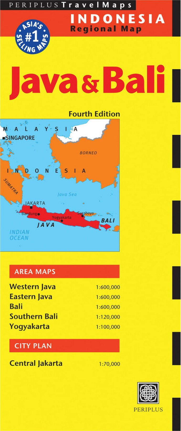
<p> Goede overzichtskaart van zowel Java als Bali. Door kleurgebruik met name hoogtes goed zichtbaar. Met afstandstabel, toeristische aanduidingen.</p> <div> The Java & Bali Travel Map from Periplus is designed as a convenient, easy-to-use tool for travelers. Created using durable coated paper, this map is made to open and fold multiple times, whether it's the entire map that you want to view or one panel at a time.</div> <div> </div> <div> Following highways and byways, this map will show you how to maneuver your way to banks, gardens, hotels, golf courses, museums, monuments, restaurants, churches and temples, movie theaters, shopping centers and more!</div> <div> </div> <div> This 4th edition includes maps and plans that are scaled to:</div> <div> </div> <div> Area Maps:</div> <div> Western Java 1:600,000</div> <div> Eastern Java 1:600,000</div> <div> Bali 1:600,000</div> <div> Southern Bali 1:120,000</div> <div> Yogyakarta 1:100,000</div> <div> City Plan:</div> <div> Central Jakarta 1:70,000</div> <div> Periplus Travel Maps cover most of the major cities and travel destinations in the Asia-Pacific region. The series includes an amazing variety of fascinating destinations, from the multifaceted subcontinent of India to the bustling city-state of Singapore and the 'western style' metropolis of Sydney to the Asian charms of Bali. All titles are continuously updated, ensuring they keep up with the considerable changes in this fast-developing part of the world. This extensive geographical reach and attention to detail mean that Periplus Travel Maps are the natural first choice for anyone traveling in the region.</div> <div> </div>
€11,95
Bekijk product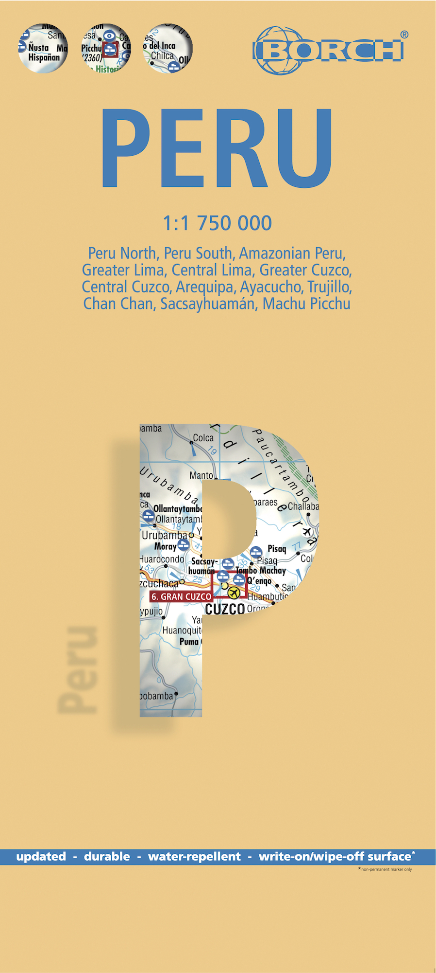
<div> <span style="color: rgb(0, 0, 0); font-family: 'Helvetica Neue', Helvetica, sans-serif, Arial;">Mooie geplasticieerde kaart van Peru. Deze kaart biedt een goed overzicht van het land met detailkaarten.</span></div> <div> </div> <div> Our soft-laminated folded map of Peru shows: Peru North 1:1 750 000, Peru South 1:1 750 000, Amazonian Peru 1:2 500 000, Central Lima 1:18 000, Greater Lima 1:150 000, Central Cuzco 1:12 000, Greater Cuzco 1:50 000, Ayacucho 1:20 000, Arequipa 1:17 000, Chan Chan 1:40 000, Trujillo 1:20 000, Sacsayhuaman 1:10 000, Machu Picchu 1:44 000, Peru administrative & time zones. Borch Maps are easy to fold, durable and water-repellent with a wipeable surface. Borch Maps show hotels, museums, monuments, markets, public transport, top sights and points of interest, useful statistics, conversion charts for temperatures, weights and measurements, climate charts showing temperatures, sunshine hours, precipitation and humidity, overview maps, time zones, and much more...</div> <div> </div> <div> Bordering Brazil, Bolivia, Chile, Colombia, Ecuador and the Pacific Ocean, the Republic of Peru is the cradle of the Inca empire. Peru is home to many parks, reservations and sanctuaries, unique flora and fauna, tropical jungles, the highest lake in the world, several deserts, a rich cultural heritage, as well as being noted for its unique art, literature, music and folklore. Just 100 kilometers inland, the Andes rise up to 6,000 meters (18,000 feet), their jagged ranges separated by deep canyons. Descending the eastern slopes, the rich cloud forests transform into the rainforest of the Amazon Basin. Mountaineers can try their luck around Huarez and the former Inca capital Cuzco; wildlife enthusiasts will be entertained by the sea lions on the Islas Ballestas near Pisco; culture and history buffs will be able to feast on Peru's archeological wealth and charming colonial cities; Chan Chan - the huge adobe capital of the Chimu (near Trujillo); the 2,500 year old Chavín ruins near Huarez; the beautiful cities of Arequipa and Cajamarca. The ultimate experience, however, is walking the famous Inca Trail, which leads through spectacular mountain scenery and past mysterious ancient ruins, until the path descends to Peru's icon - legendary Machu Picchu - detailed on our map.</div> <div> </div>
€11,50
Bekijk product
<p> Overzichtskaart met alle noodzakelijke informatie. Goed kleurgebruik.</p> <div> </div> <div> Legend Includes:</div> <div> Boundary, national park boundary, capitals, villages, world heritage site, airport, heliport, ferry and other information.</div> <div> </div> <div> This map has just run out of copies. I know; how can anyone update Greenland? Well, we still have to update the program language to modern usage, and who knows, maybe we have to correct some errors. I don't know. Anyway, it's being updated, whoopie deal. It should be available again in January or February. The North Pole side was updated by Canada Map Office just before we first published this title, so needs no alteration. This title, by the way, has proven to be quite popular.</div> <div> </div>
€13,95
Bekijk product
<p> Een degelijke kaart met aanduidingen van o.a. nationale parken, vliegveld, benzinepomp, dirt-roads en kleine plattegrond van hoofdstad. Als overzichtskaart goed te gebruiken.</p> <p> Folded road and travel map in color. Scale 1: 200.000 and 1:350,000. Distinguishes roads ranging from paved roads to tracks (4 wheel drive). Legend includes railway with stations, bordercrossings, border control points, airports (tarred runway), airstrips, hospitals, clinics, outstations, museums, hotels, lodges or rest houses, sites of battle, points of interest. Includes inset map of Maseru.</p>
€13,95
Bekijk product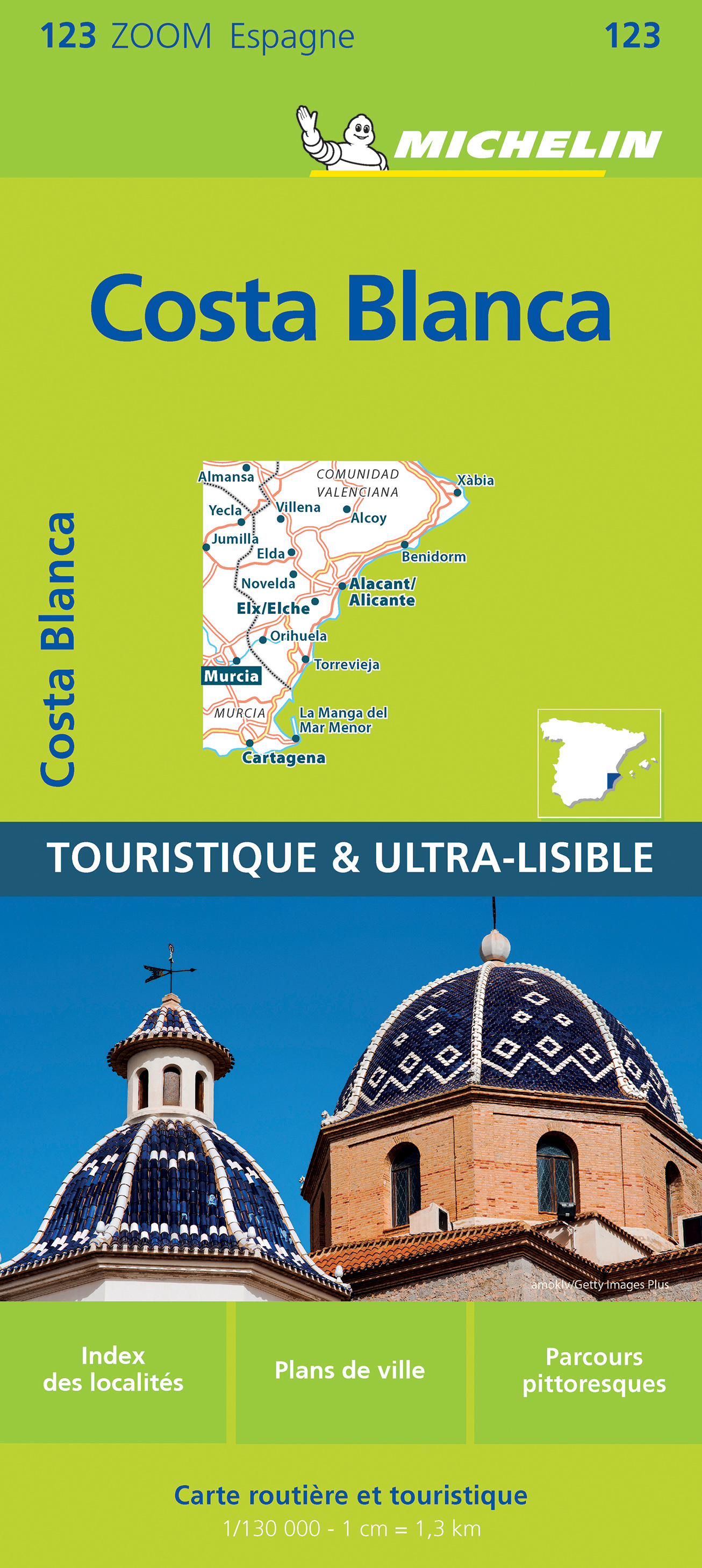
<p> Zoals gewend van Michelin een zeer leesbare kaart met alle gewenste details. Alle berijdbare wegen staan duidelijk ingetekend, groene lijnen geven de mooiste stukken aan. Inclusief plattegronden van het centrum van Alicante - Murcia en Cartegena<br /> </p> <p> Costa Blanca, Espagne, Murcie</p>
€10,95
Bekijk product