
Beantwoord enkele vragen, en binnen seconden geeft AI je een persoonlijk aankoopadvies op maat.
Beantwoord enkele vragen, en binnen seconden geeft AI je een persoonlijk aankoopadvies op maat.
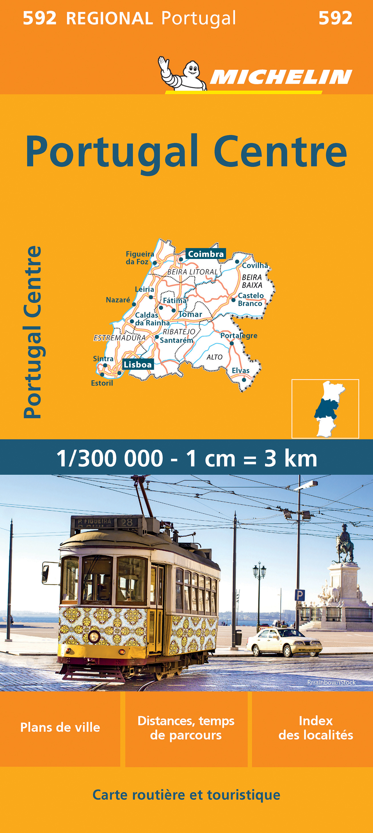
<div> Zoals je van Michelin mag verwachten zijn het onmisbare overzichtskaarten van een uitstekende kwaliteit: een duidelijk en goed leesbaar kaartbeeld. Vrijwel alle berijdbare wegen staan er op ingetekend, in kleur verschillend voor grote en kleine wegen. Andere weginformatie omvat bijvoorbeeld kilometer-afstanden, tolwegen, helling-aanduiding, winterafsluitingen, tankstations maar ook de bekende groene routes: de mooiste wegen om te rijden.</div> <div> </div> <div> Daarnaast geeft de kaart toeristische informatie met symbolen weer: bezienswaardigheden als kastelen, kloosters, musea, maar ook campings (niet allemaal overigens). De kaart is voorzien van een 4-talige legenda.</div> <div> </div> <div> Toch hebben de makers door een beperkt gebruik van symbolen geen drukke kaart gemaakt. De kracht zit hem dan ook in de combinatie van meer dan voldoende informatie en goede leesbaarheid. </div> <div> </div> <div> Part of the orange regional series from Michelin, this Portugal Centre map shows this part of Portugal in excellent detail. Primary & secondary road networks are clearly marked out with indications of the number of lanes, intermediate distances and various possible road obstacles or things you should know including steep hills, height limits, toll barriers, prohibited roads and roads subject to restrictions.</div> <div> </div> <div> The map also includes small insets with street plans of Lisbon, Leiria, Coimra, Castelo Branco, Portalegre and Santarem, showing road names, one way streets and various places of interest (tourist sights, hospitals, parking, railway stations, etc.). Scenic routes on the map are marked out in green and an extensive index of place names is included.</div> <div> </div> <div> The map also features:</div> <div> </div> <div> Administrative boundaries</div> <div> Railways, Airports and Ferry Services</div> <div> Important sights such as castles, ruins, and churches</div> <div> Driving Times and Distance Charts</div> <div> Road Safety Information</div> <div> A legend in multiple languages, including English</div> <div> </div> <div> Coimbra, Lisbonne, Portugal</div>
€11,95
Bekijk product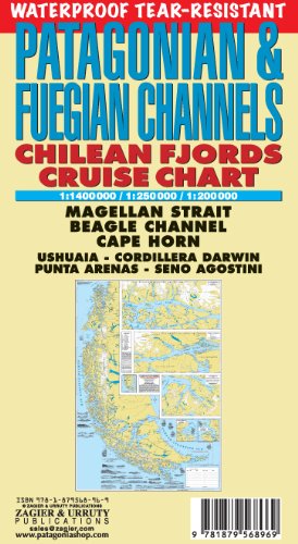
<p> Intricate representation of Chilean fjords along the western and far southern edge of southern South America. This clear and uncluttered map shows details of the coastline with minimal topographical information. Historical notes and elevations of coastline illustrated from different bearings. Scale 1:1,400,000</p> <p> Historical and hydrographical chart. Cruise log for the intrincate coast of the south of South America. Insets of Beagle Channel "Glaciers Avenue", Agostini Fjord, Wulaia Inlet and Romanche Bay</p> <p> </p> <p> Kaap Hoorn, Straat Magellaan, Punta Arenas, Ushuaia, Cordillera Darwin, Seno Agostini</p> <p> Uitgevouwen 70 x 100 cm</p>
€22,95
Bekijk product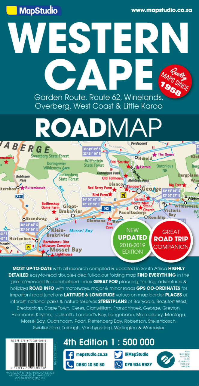
<p> Road map of the Western Cape Province with an enlargement for the Cape Peninsula and 27 street plans of the central areas in main towns. The map is annotated numerous places of interest, vineyards, etc. GPS coordinates are provides for main road junctions.</p> <div> This new edition Western Cape Road Map covers the whole of the Western Cape. It features easy-to-read full colour maps with GPS co-ordinates. The map provides tourist-friendly text, highlights places of interest and lists accommodation information. This map is perfect for scenic drives and includes information boxes on activities of interest.</div> <div> </div> <div> Coverage includes the Garden Route & Route 62, South Western Cape, Winelands and Overberg, West Coast Flower Region and Little Karoo. The map features small detailed street plans of Cape Town CBD, Montagu, Barrydale, Ladismith, Oudtshoorn, Mossel Bay, Knysna, Plettenberg Bay, Humansdorp, George, Stellenbosch, Franschhoek, Paarl, Wellington, Hermanus, Swellendam, Robertson, Ceres, Tulbagh, Langebaan and Beaufort West.</div> <p> Barrydale, Beaufort West, Bella vista, Bellville, Betty's Bay, Bo-wadrif, Bonnievale, Bredasdorp, Caledon, cape town, Cederberg, Ceres, Clanwilliam, Darling, De Kelders, Durbanville, Fishhoek, Franshoek, Ganadendal, garden route, Geodverwacht, George, Greyton, Hermanus, Hottentotskloof, Knysna, Kommetjie, Kuilsriver, Ladismith, Lainsburg, Lambert's bay, Langebaan, Malmesbury, Matjiesfontein, McGregor, Milnerton, MitchellsPlain, Montagu, Mossel Bay, Muizenburg, Noordhoek, Oudtshoorn, Paarl, Plettenburg Bay, Prince Alfred, Riviersonderend, road map, road maps, Robertson, Rouxpas, Simons Town, Stellenbosch, Sutherland, Swellendam, The Baths, Touws River, Tulbagh, Tweefontein, Vanrhynsdorp, Wellington, Western Cape, Western Cape Road Map, Worcester</p> <p> </p>
€16,95
Bekijk product
<p> Goede betrouwbare kaart van het noordwesten van Namibië: Damaraland en Kaokoland. Met GPS coordinaten. Engels</p> <p> Colour folding Map, 52x73 cm, scale 1:620.000. The first scale road map of this area to be produced with GPS co-ordinates. 100 GPS Co-ordinates of major intersections, refuelling points and accommodation information.</p> <p> Map range 11°45’ to 15°00’ East and 17° to 20°00’ South.</p> <p> <span style="font-size: 12px;">Detailed road map Kaokoland / Kaokoveld (Namibia) includes GPS co-ordinates of major intersections, refuelling points and accomodation information.</span></p> <div> </div> <div> This map covers North-Western Namibia on the one side and BUSHMANLAND and CAPRIVI in North-Eastern Namibia on the reverse side. This map is very much recommended for travelers to these regions as an addition to our bigger scaled Namibia map. Here you get a nice amplified look at the regions with loads of GPS coordinates, accommodation and petrol points. Furthermore we included extensive route and travel ideas and general information on Kaokoland. Sold in a plastic pouch.</div> <div> </div> <div> This picture of the map shows Kaokoland in North West Namibia at a scale of 1:620 000. The reverse side of the map features Bushmanland and Caprivi in North-Eastern Namibia at a scale of 1: 470 000.</div>
€15,95
Bekijk product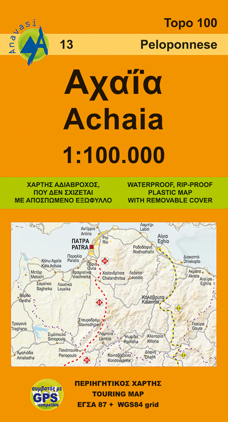
<p> Gebaseerd op topografische kaarten, GPS compatible, gedrukt op watervast en scheurvast papier. Hoogtelijnen met 100 m interval, schaduwkleuren en punten met hoogte geven de topografie van het landschap aan. De kaart kent een UTM grid.</p> <p> Het wegennet wordt aangeduid met verschillende gradaties: grote en kleine wegen, verhard en onverhard. Toeristische bezienswaardigheden staan als zodanig aangeduid zoals thermen, kloosters, berghutten, grotten etc. Namen van steden zowel in het normale schrift als in het Grieks, met een legenda die ook in het Engels is.</p> <p> Blessed with all the natural wealth of the Peloponnese, Achaia's fertile plains and welcoming mountains are popular destinations for touring all the year round. On the new edition the trail E4 and 31 (from Patras to Ancient Olympia) are marked. On the inner side of the detachable folder there is a small plan of the capital city of Achaia, Patras with highlights of the most important sites.</p>
€9,95
Bekijk product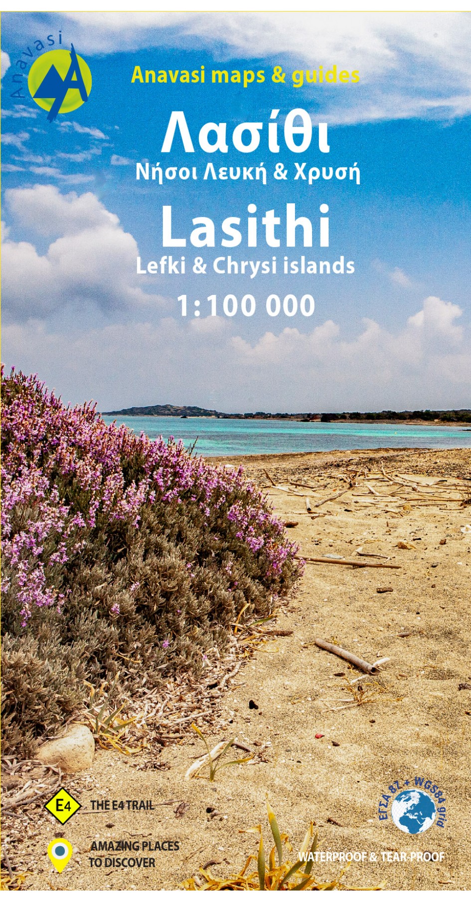
<p> Gebaseerd op topografische kaarten, GPS compatible, gedrukt op watervast en scheurvast papier. Hoogtelijnen met 100 m interval, schaduwkleuren en punten met hoogte geven de topografie van het landschap aan. De kaart kent een UTM grid.</p> <p> Het wegennet wordt aangeduid met verschillende gradaties: grote en kleine wegen, verhard en onverhard. Toeristische bezienswaardigheden staan als zodanig aangeduid zoals thermen, kloosters, berghutten, grotten etc. Namen van steden zowel in het normale schrift als in het Grieks, met een legenda die ook in het Engels is.</p> <p> <strong>Van de uitgever</strong></p> <div> This map includes all the information a traveler needs to discover Eastern Crete. It includes the entire road network from the biggest arteries to the smallest dirt roads, paths and trails, all the towns and villages, beaches and toponyms. In addition to the above, you will find the E4 route from Dikti to Zakros that crosses the entire inland of Eastern Crete. On the reverse side you will find sections of the E4 route with elevation profiles as well as an index of settlements so you can easily locate them on the map. It also contains a city plan of Aghios Nikolaos, the capital of Lasithi.</div> <div> </div> <div> Printed on waterproof & tear resistant polyart paper.</div>
€11,95
Bekijk product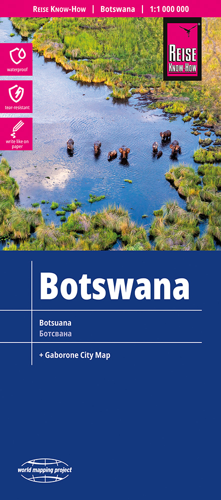
<p> Uitstekende kaart van Botswana. <span style="font-family: 'Helvetica Neue', Helvetica, sans-serif, Arial; line-height: 15.833333015441895px; font-size: 12px;">Tweetalige kaart (Engels en Duits). Door ingetekende lengte- en breedtegraden is het gebruik van GPS mogelijk. Met hoogtelijnen en uitgebreid wegennetwerk: daarnaast worden ook de afstanden tussen belangrijke plaatsen duidelijk leesbaar weergegeven. Het kleurgebruik is zodanig dat je een goede indruk krijgt van hoogteverschillen en soorten landschap. Natuurlijk staan de toeristische bezienswaardigheden duidelijk vermeld. Met centrumkaart van Gabarone.</span></p> <p style="line-height: 15.833333015441895px; margin: 0px 0px 10px; padding-left: 0px; font-family: 'Helvetica Neue', Helvetica, sans-serif, Arial;"> Gedrukt op water- en scheurvast papier! Polyart is een synthetisch product vrij van giftige stoffen dus duurzaam. Het papier gaat echt lang mee.</p> <div style="font-family: 'Helvetica Neue', Helvetica, sans-serif, Arial;"> Topography is indicated by altitude colouring with numerous spot heights and names of mountain ranges and passes. Salt lakes, swamps, seasonal rivers and glacier are also shown. Detailed presentation of the road network includes minor roads and tracks and railways are also shown.</div> <div style="font-family: 'Helvetica Neue', Helvetica, sans-serif, Arial;"> </div> <div style="font-family: 'Helvetica Neue', Helvetica, sans-serif, Arial;"> Internal administrative units are presented with their boundaries and names. National parks and other protected areas are highlighted. A wide range of symbols mark various places of interest. Map legends include English and all the maps have an index of localities.</div> <p> </p>
€15,95
Bekijk product
<div> Tweetalige kaart (Engels en Duits). Door ingetekende lengte- en breedtegraden is het gebruik van GPS mogelijk. Met hoogtelijnen en uitgebreid wegennetwerk: daarnaast worden ook de afstanden tussen belangrijke plaatsen duidelijk leesbaar weergegeven. Het kleurgebruik is zodanig dat je een goede indruk krijgt van hoogteverschillen en soorten landschap. Natuurlijk staan de toeristische bezienswaardigheden duidelijk vermeld.</div> <div> </div> <div> Gedrukt op water- en scheurvast papier! Polyart is een synthetisch product vrij van giftige stoffen dus duurzaam. Het papier gaat echt lang mee.</div> <div> </div> <div> Topography is indicated by altitude colouring with numerous spot heights and names of mountain ranges and passes. Salt lakes, swamps, seasonal rivers and glacier are also shown. Detailed presentation of the road network includes minor roads and tracks and railways are also shown.</div> <div> </div> <div> Internal administrative units are presented with their boundaries and names. National parks and other protected areas are highlighted. A wide range of symbols mark various places of interest. Map legends include English and all the maps have an index of localities.</div> <p> </p>
€11,50
Bekijk product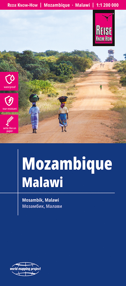
<div> Tweetalige kaart (Engels en Duits) van Mozambique en Malawi. Door ingetekende lengte- en breedtegraden is het gebruik van GPS mogelijk. Met hoogtelijnen en uitgebreid wegennetwerk: daarnaast worden ook de afstanden tussen belangrijke plaatsen duidelijk leesbaar weergegeven. Het kleurgebruik is zodanig dat je een goede indruk krijgt van hoogteverschillen en soorten landschap. Natuurlijk staan de toeristische bezienswaardigheden duidelijk vermeld. Met plattegronden (centrum) van Maputo en Lilongwe.</div> <div> </div> <div> Gedrukt op water- en scheurvast papier! Polyart is een synthetisch product vrij van giftige stoffen dus duurzaam. Het papier gaat echt lang mee.</div> <div> </div> <div> Topography is indicated by altitude colouring with numerous spot heights and names of mountain ranges and passes. Salt lakes, swamps, seasonal rivers and glacier are also shown. Detailed presentation of the road network includes minor roads and tracks and railways are also shown.</div> <div> </div> <div> Internal administrative units are presented with their boundaries and names. National parks and other protected areas are highlighted. A wide range of symbols mark various places of interest. Map legends include English and all the maps have an index of localities.</div> <div> </div> <p> </p>
€15,95
Bekijk product
<div> Tweetalige kaart (Engels en Duits). Door ingetekende lengte- en breedtegraden is het gebruik van GPS mogelijk. Met hoogtelijnen en uitgebreid wegennetwerk: daarnaast worden ook de afstanden tussen belangrijke plaatsen duidelijk leesbaar weergegeven. Het kleurgebruik is zodanig dat je een goede indruk krijgt van hoogteverschillen en soorten landschap. Natuurlijk staan de toeristische bezienswaardigheden duidelijk vermeld.</div> <div> </div> <div> Gedrukt op water- en scheurvast papier! Polyart is een synthetisch product vrij van giftige stoffen dus duurzaam. Het papier gaat echt lang mee.</div> <div> </div> <div> Topography is indicated by altitude colouring with numerous spot heights and names of mountain ranges and passes. Salt lakes, swamps, seasonal rivers and glacier are also shown. Detailed presentation of the road network includes minor roads and tracks and railways are also shown.</div> <div> </div> <div> Internal administrative units are presented with their boundaries and names. National parks and other protected areas are highlighted. A wide range of symbols mark various places of interest. Map legends include English and all the maps have an index of localities.</div>
€11,50
Bekijk product