
Beantwoord enkele vragen, en binnen seconden geeft AI je een persoonlijk aankoopadvies op maat.
Beantwoord enkele vragen, en binnen seconden geeft AI je een persoonlijk aankoopadvies op maat.
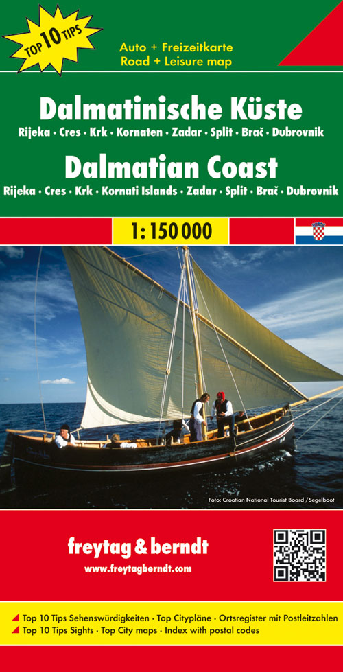
<p> Uitstekende tweezijdige wegenkaart van een groot deel van de Dalmatische kust van Kroatie. Zeer gedetailleerde kaart met topografische details, maar ook campings. Ideaal om deze eilanden per boot of auto / fiets te ontdekken. Alle bezienswaardigheden staan zeer goed aangegeven. Met register en enkele stadsplattegronden.</p> <div> Dalmatian Coast "Top 10 Tips" Map at 1:150,000 from Freytag & Berndt with a booklet containing an index, brief descriptions of region’s 10 most popular destinations, plus street plans of Dubrovnik’s Old Town and central Pula, Rijeka, Split, Sibenik and Zadar.</div> <div> </div> <div> The map is double-sided and presents the region in three sections, as indicated on our area coverage image (NB. Istrian Peninsula is included). Topography is shown by relief shading with spot heights, with plenty of names of mountain and hill chains, etc. National parks and other protected areas are clearly marked. </div> <div> </div> <div> Road network includes small local roads and selected cart tracks, and indicates motorway services, routes closed to traffic or not recommended for caravans, seasonal closures, gradients for steep roads, tourist routes and scenic roads, etc. Railways and ferry routes to the islands are marked. </div> <div> </div> <div> Picturesque towns and villages are highlighted. The region’s 10 top sights are prominently marked, with brief descriptions provided in a booklet attached to the map cover. Symbols mark other places of interest and facilities, including campsites and youth hostels, marinas, golf courses, museums, churches and castles, viewpoints, etc. Latitude and longitude lines are drawn at intervals of 10’.</div> <div> </div> <div> The booklet attached to the map cover also includes an index listing all localities with their postcodes, plus street plans of Dubrovnik’s Old Town and central Pula, Rijeka, Split, Sibenik and Zadar.</div>
€14,95
Bekijk product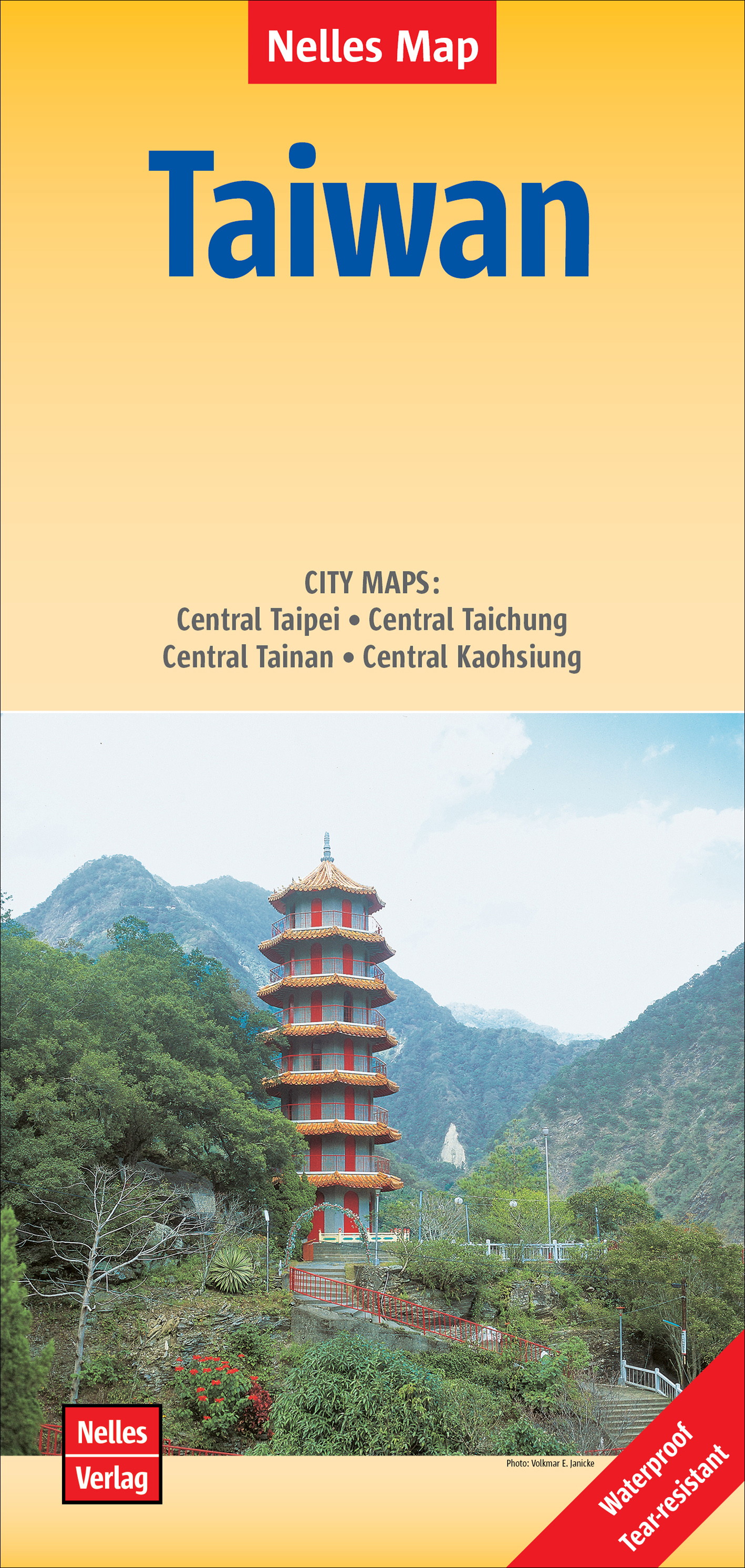
<p> Goede geplastificeerde wegenkaart van Taiwan. Aan beide kanten bedrukt. Met veel toeristische aanduidingen als nationale parken en culturele bezienswaardigheden. Prima leesbare kaart.</p> <p> Kaohsiung 1 : 30.000<br /> Taichung 1 : 20.000<br /> Tainan 1 : 20.000<br /> Taipei 1 : 30.000</p> <div> Folded road and tourist map of Taiwan at 1:400,000 scale. Places of interest, national parks, and beaches are all highlighted and shaded-relief colouring clearly depicts the topography. </div> <div> </div> <div> The map includes insets shwoing Taipei at 1:30 000, Taichung at 1:20 000, Tainan at 1:20 000, and Kaohsiung at 1:30 000. The legend is in three languages including English.</div> <div> </div> <div> For over 20 years Nelles maps have been renowned throughout the world for their quality, faithfulness to detail and up-to-dateness. </div> <div> </div> <div> So that streets, ferry links, railway lines, etc are always up to date, Nelles are continuously upgrading their maps - with the help of their international team of correspondents. Roads are provided with an exact kilometerage. Sights are highlighted extra clearly so that you don't miss any tourist attractions.</div> <div> </div> <div> A good map must be hard-wearing and allow itself to be folded up simply and quickly. Nelles Maps are a handy pocket size with the reliable, practical concertina fold. In addition they use an extra high-quality speciality paper resulting in considerably increased fold strength.</div>
€11,95
Bekijk product
<p> Uitstekende wegenkaart van Zuid Afrika met zowel de toeristische informatie als Nationale Parken en bezienswaardigheden, maar ook de topografische details en afstanden. Gedrukt op 'waterproof' papier.</p> <p> Double-sided map of South Africa printed on waterproof and tear-resistant synthetic paper, with plans of Cape Town, Johannesburg and Pretoria. The map divides the country east/west with a small overlap between the two sides. Elevation tinting in feet shows the general relief. Mountain passes are marked, but there are no spot heights.</p> <p> Road network includes selected local tracks, gives driving distances on major and secondary roads and indicates border crossings. Railways, major ferry connections and local airports are also shown. National parks and protected areas are marked and symbols highlight various places of interest, campsites or huts, rest houses and other tourist accommodation, beaches and diving sites, etc. Presentation of Lesotho and Swaziland is the same as for South Africa.</p> <p> Latitude and longitude lines are marked at 1 degree intervals. The map is indexed and includes street plans of central Cape Town, Johannesburg, and Pretoria, highlighting selected accommodation, places of interest and various facilities.</p> <p> </p>
€13,95
Bekijk product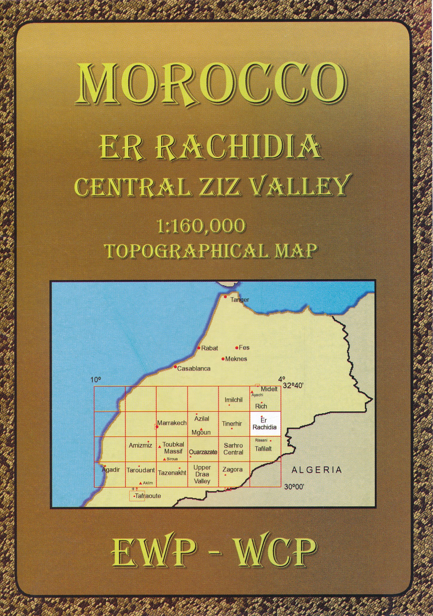
<div> Deze kaart maakt deel uit van meerdere gedetailleerde topografische kaarten van het Atlas Gebergte en de daaraan grenzende woestijnen. Elke kaart heeft lokale toeristische info op de achterzijde en is in het Frans en Engels beschreven</div> <div> </div> <div> Hoogte in hoogtelijnen met 40m interval en een aantal punten. Verdere vermelding van terreinsoort, vegetatie, waterpunten, kliffen, duinen, ravijnen, zoutpannen etc. Bij wegen onderscheid in onverhard, verhard en tracks. Bebouwing, vliegvelden, stations, elektrische leidingen. Voor sommige passen is er een indicatie wanneer deze begaanbaar is.</div> <div> </div> <div> De uitgever EWP meldt dat deze kaarten geschikt zijn voor het gebruik van GPS: "The main grid drawn over the mapping is based on the Kronstadt system which related closely to the UTM system, and which the publishers assure us is suitable for a GPS set to UTM or MGRS".</div>
€19,95
Bekijk product
<p> Gedetailleerde, tweezijdige landkaart van Italië, prima geschikt voor planning en rondtrekken. De berijdbare wegen zijn goed weergeven, zowel de hoofdwegen als provinciale en lokale wegen; wegnummers worden vermeld. Afstanden tussen plaatsen zijn in kilometers op de kaart ingetekend, daarnaast worden ook op belangrijke plekken benzinepompen gemarkeerd. In het kaartbeeld wordt door middel van schaduw het reliëf weergegeven en soms enkele punten in het landschap met de daadwerkelijke hoogte. Provinciegrenzen zijn goed terug te vinden, nationale parken en reservaten ook. Met allerhande symbolen worden toeristische bezienswaardigheden weergegeven als monumenten, historisch belangrijke plekken en uitzichtpunten. In bepaalde plaatsen zijn hotels en campings te vinden, luchthavens, treinverbindingen en havens vindt u er ook op!</p> <p> <span style="font-size: 12px;">Explore Italy with this Freytag & Berndt double-sided road map. The best way to plan your trip, prepare your itinerary, and to travel independently in this country. As with all Freytag & Berndt maps the cartography is clear and detailed with the topography shown by relief shading with plenty of spot heights.</span></p> <div> <span style="font-size: 12px;">The map includes a localities index and inset maps of Ancona, Bari, Cagliari, Bozen / Bolzano, Florence, Genova, Milan, Naples, Palermo, Rome, Torino, Venice. </span></div> <div> </div> <div> Tourist information and places of interest are clearly marked by a range of icons, including: </div> <div> </div> <div> airports</div> <div> monasteries, castles, ruins and antique sites</div> <div> accommodation</div> <div> caves</div> <div> mountain cabins</div> <div> spas</div> <div> marinas</div> <div> camping sites</div> <div> monuments</div> <div> view points</div> <div> </div> <div> Distances between points are shown as well as indications of steep gradients, all distances are in kilometres. The legend is in 10 languages (English, Italian and German included).</div> <p> </p>
€14,95
Bekijk product
<div> De ANWB heeft een grote serie wegenkaarten van de belangrijkste landen en streken. Het zijn echte overzichtskaarten van vaak een wat groter gebied. Deze keuze zorgt er voor dat de schaal vrij grof is en bepaalde details zijn weggelaten. De kleurstelling is een beetje flets waardoor je niet altijd even makkelijk onderscheid kan maken tussen verschillende landschappen of natuurlijke aspecten. </div> <div> Ook het register ontbreekt. Het grote voordeel is vaak dat het gebied op de kaart overeenkomt met de vraag van klanten. Voor het plannen van een vakantie een prima kaart!</div> <div> </div> <div> Vergeleken met andere uitgevers van kaarten als Michelin, Freytag und Berndt of Reise KnowHow heeft de ANWB duidelijke keuzes gemaakt en gekozen voor een echte overzichtskaart. </div> <div> </div> <div> MET DE ANWB WEGENKAART, WEET JE WAAR JE STAAT! ANWB wegenkaarten zijn een begrip in het land. Dat laten de verkoopcijfers ook zien. Afgelopen decennia zijn meer dan 10 miljoen kaarten over de toonbank gegaan. De wegenkaarten zijn allemaal vernieuwd, met dikker karton voor de omslagen en papier dat minder makkelijk scheurt, zodat ze veelvuldig in- en uitgevouwen kunnen worden. Ze bieden een duidelijker overzicht van het wegennet en zijn nu nog compacter en handzamer. </div>
€12,99
Bekijk product
<p> <span style="font-family: verdana, arial, sans-serif; font-size: 11px;">Goede overzichtelijke wegenkaart van de zuidelijke helft van Duitsland met register en afstandentabel.</span></p> <div> <div> Mit Download-Code für gratis Kartenversion auf Smartphone!</div> <div> </div> <div> Mit E-Distoguide® via QR-Code. Die Vernetzung von Print und Web für noch mehr Flexibilität. </div> <div> Über 2000 Entfernungsangaben sind jetzt mittels QR-Code direkt mit dem Handy überall abrufbar!</div> <div> </div> <div> Strassenkarte mit Transitplänen, Ortsindex, touristische Informationen und Sehenswürdigkeiten.</div> <div> Aktuelle Information, übersichtliche Darstellung, einfache Handhabung: das Markenzeichen der Hallwag-Strassenkarten. Das internationale Programm mit neuen Ideen für besseres Reisen bietet Ihnen überzeugende Vorteile.</div> <div> </div> </div> <p> </p>
€14,50
Bekijk product
<p> Speciale toeristische kaart voor de Canarische Eilanden. Gemaakt voor een goed bezocht gebied en uitvergroot. Daardoor zeer prettig leesbaar met een hoog niveau wat we van Michelin al veel langer gewend zijn. Alle wegen staan er op, met verschillende kleuren voor de aparte soorten wegen. Verder veel aandacht met symbolen voor de bezienswaardigheden in de regio, de bekende groene stroken naast de mooie wegen</p> <p> Fuerteventura, Iles Canaries, Lanzarote</p>
€10,95
Bekijk product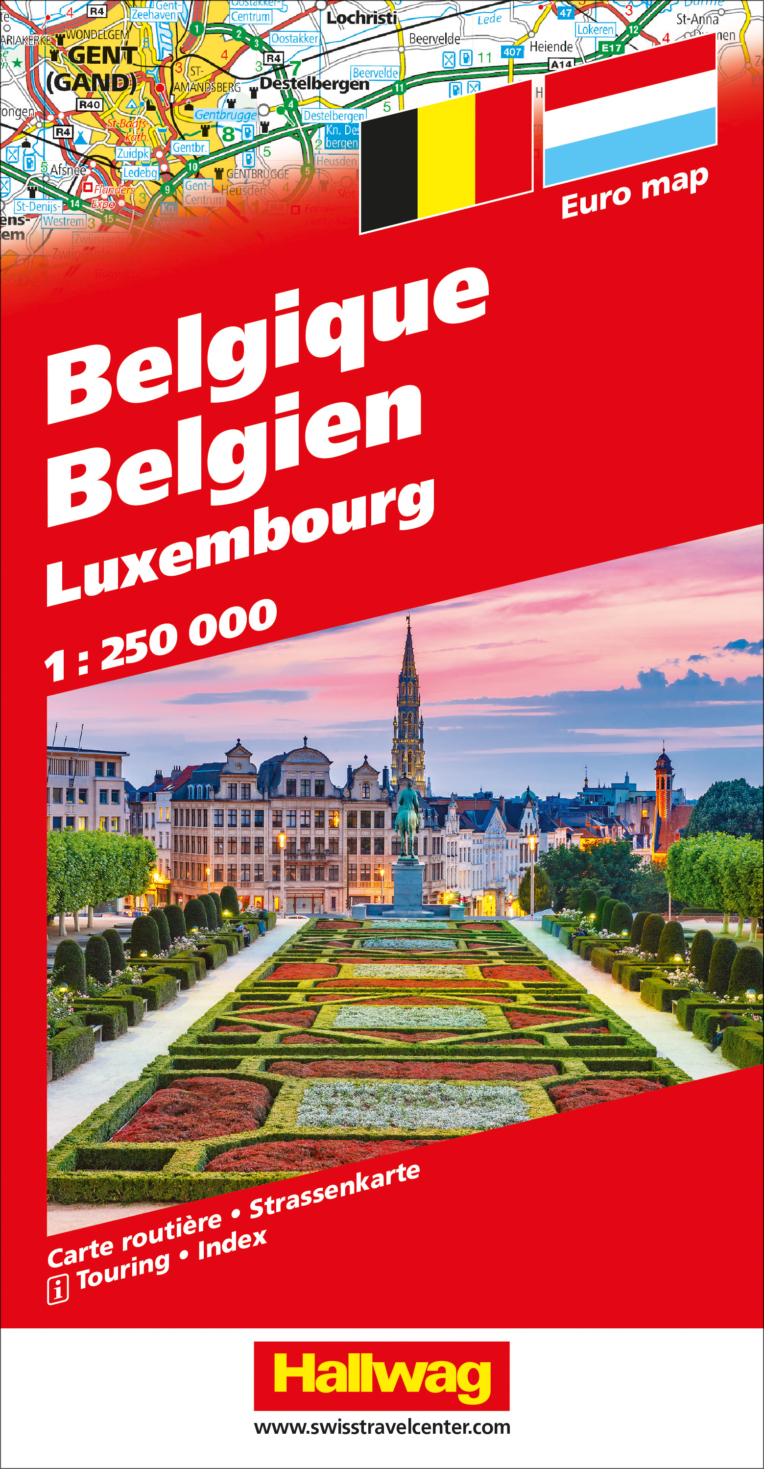
<p> Zeer goede, gedetailleerde en up-to-date autokaart van België en Luxemburg. Met afstandentabel en uitgebreide legenda en index.</p> <p> Hallwag road maps are renowned for their up-to-date information, clear layout and convenience. See for yourself the benefits of the Hallwag international map collection, with new ideas to make travel even easier.</p> <p> The map also covers the north east of France. A range of symbols indicate information for tourists including: places of interests, viewpoints, natural curiosities, notable buildings and ruins, monuments, monasteries and churches, yearly and seasonal campsites, windmills, lighthouses and golf courses.</p> <p> The map includes extensive transportation detail, multiple language information (English, German, Italian, and French), and a complete multiple language index. There are also inset maps showing more detail of the major cities. Relief shading clearly shows the topography of the land.</p> <p> The map also includes Hallwag's Distoguide - the integrated mileage chart - on the outer map cover which is quick and easy to use and extremely practical for planning and travel. Simply read off more than 2000 distances on the sliding mileage chart integreated in the map cover.</p>
€14,50
Bekijk product
<p> <span style="font-size: 12px;">Senegal, Gambia, Guinee-Bissau, Guinee, Sierra Leone, Liberia, Ghana, Togo, Benin, Ivoorkust, Nigeria</span></p> <p> The map is double-sided to provide the best balance between a good scale and a convenient size sheet and covers countries from Senegal to Nigeria, Burkina Faso, plus southern Mali, with inset showing the Cape Verde Islands.</p> <div> Tweetalige kaart (Engels en Duits). Door ingetekende lengte- en breedtegraden is het gebruik van GPS mogelijk. Met hoogtelijnen en uitgebreid wegennetwerk: daarnaast worden ook de afstanden tussen belangrijke plaatsen duidelijk leesbaar weergegeven. Het kleurgebruik is zodanig dat je een goede indruk krijgt van hoogteverschillen en soorten landschap. Natuurlijk staan de toeristische bezienswaardigheden duidelijk vermeld.</div> <div> </div> <div> Gedrukt op water- en scheurvast papier! Polyart is een synthetisch product vrij van giftige stoffen dus duurzaam. Het papier gaat echt lang mee.</div> <div> </div> <div> Topography is indicated by altitude colouring with numerous spot heights and names of mountain ranges and passes. Salt lakes, swamps, seasonal rivers and glacier are also shown. Detailed presentation of the road network includes minor roads and tracks and railways are also shown.</div> <div> </div> <div> Internal administrative units are presented with their boundaries and names. National parks and other protected areas are highlighted. A wide range of symbols mark various places of interest. Map legends include English and all the maps have an index of localities.</div>
€11,50
Bekijk product