
Beantwoord enkele vragen, en binnen seconden geeft AI je een persoonlijk aankoopadvies op maat.
Beantwoord enkele vragen, en binnen seconden geeft AI je een persoonlijk aankoopadvies op maat.
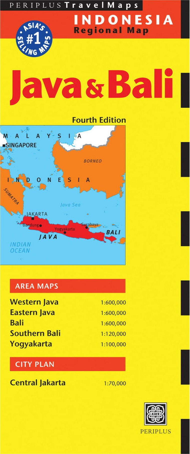
<p> Goede overzichtskaart van zowel Java als Bali. Door kleurgebruik met name hoogtes goed zichtbaar. Met afstandstabel, toeristische aanduidingen.</p> <div> The Java & Bali Travel Map from Periplus is designed as a convenient, easy-to-use tool for travelers. Created using durable coated paper, this map is made to open and fold multiple times, whether it's the entire map that you want to view or one panel at a time.</div> <div> </div> <div> Following highways and byways, this map will show you how to maneuver your way to banks, gardens, hotels, golf courses, museums, monuments, restaurants, churches and temples, movie theaters, shopping centers and more!</div> <div> </div> <div> This 4th edition includes maps and plans that are scaled to:</div> <div> </div> <div> Area Maps:</div> <div> Western Java 1:600,000</div> <div> Eastern Java 1:600,000</div> <div> Bali 1:600,000</div> <div> Southern Bali 1:120,000</div> <div> Yogyakarta 1:100,000</div> <div> City Plan:</div> <div> Central Jakarta 1:70,000</div> <div> Periplus Travel Maps cover most of the major cities and travel destinations in the Asia-Pacific region. The series includes an amazing variety of fascinating destinations, from the multifaceted subcontinent of India to the bustling city-state of Singapore and the 'western style' metropolis of Sydney to the Asian charms of Bali. All titles are continuously updated, ensuring they keep up with the considerable changes in this fast-developing part of the world. This extensive geographical reach and attention to detail mean that Periplus Travel Maps are the natural first choice for anyone traveling in the region.</div> <div> </div>
€11,95
Bekijk product
<p> Gedetailleerde kaart van een bepaald gebied in Canada, in dit geval een wegenkaart van Wells Gray national park (schaal 1:250.000) en een wandelkaart / topografische kaart van Murtle lake (schaal 1:50.000). </p> <p> Helder en duidelijk kleurgebruik, goed leesbaar en op de Wells Gray kaart met symbolen onder andere campsites, trails, benzinepompen etc. </p> <p> Double sided, very detailed hiking map, with recreational information, based on the government topographic cartography. Scale 1:50,000. Legend includes points of interest, airports/airstrips, Forest Service offices, RV/camping/ recreation sites, wilderness camps. shelters, campsites/trailer parks, picnic areas, accommodations, parking, waterfalls, horseback riding, mountain biking, cross country skiing, canoeing, hiking, viewpoints, mountain climbing, golf courses, fishing, boat launches, gas stations, restaurants, gates, national/provincial parks. Printed on durable synthetic paper suitable for outdoor use.</p> <p> </p>
€13,95
Bekijk product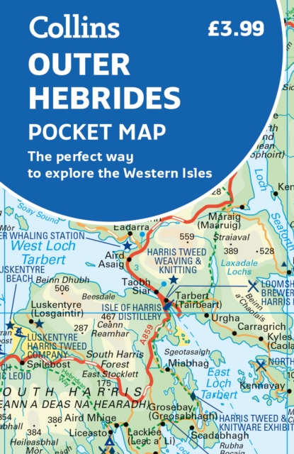
<div> Explore new places with handy pocket maps from Collins. Handy little full-colour map of the Western Isles of Scotland. Detailed mapping and tourist information for the islands of Lewis, Harris, Uist, Benbecula, Barra and St Kilda.</div> <div> </div> <div> Excellent value and very detailed for its size. Famed for its stunning coastline, wildlife and traditional food and drink, the Outer Hebrides have a distinct identity. Discover these unique islands with this handy pocket map.</div> <div> </div> <div> Main features of this map include: Clear mapping at a scale of 3.2 miles to 1 inchTourist attractions located and describedSights, places to stay, cafe/restaurant, things to do are all highlighted on the mapTransport links map showing how to get to and depart the islandsIndex to places of interest and place names Essential for those planning a trip around the Western Isles.</div>
€7,95
Bekijk product
<div> Handy full-colour map of Ireland’s Wild Atlantic Way with a high level of detail. Clear mapping of the full 2500 km (over 1500 miles) route, showing the road network and places of interest.</div> <div> </div> <div> Clear, detailed Collins road mapping is presented in a handy format ideal for the pocket or handbag. It is excellent value and very detailed for its size, covering the whole of the Wild Atlantic Way.</div> <div> </div> <div> Ideal for tourists, locals, hikers and adventurers. Places of interest marked, including famous film locations.</div> <div> </div> <div> This map includes:</div> <div> • Clear mapping at a scale of 8.7 miles to 1 inch</div> <div> • National Tourist Routes showing best routes through the most scenic areas</div> <div> • Places of interest include film locations such as Star Wars</div> <div> • Tourist and signature locations clearly marked</div> <div> • Suggested itineraries</div> <div> • Detailed place names index</div> <div> • Ideal companion to a sat-nav – it enables route planning and route sense-checking</div>
€7,95
Bekijk product
<div> The volcanic cone of Mount Fuji is Japan’s most popular touristic attraction. Located a short train ride west of Tokyo, Fuji attracts millions of visitors each year. Side 1 focuses on the mountain itself, showing rail connections, surrounding towns, roads on the lower slopes, hiking trails, and accommodations close to the summit. Side 2 shows the Kanto & Chubu Regions from Tokyo to Nagoya and north to Nigata. This is a brand new ITMB title.</div> <div> </div> <div> Legend Includes:</div> <div> Roads by classification, Rivers and Lakes, National Park, Airports, Points of Interests, Highways, Main Roads, Zoos, Fishing, and much more...</div>
€13,95
Bekijk product
<div> Australia was one of the first countries ITMB published, back in the 1980s, albeit a licensed version. Our own original artwork was completed in the mid-1990s, but until recently, we have not focused on sectional maps of the country based on individual states. In 2019, we published Brisbane and Queensland, and Sydney and New South Wales. Now, we are issuing the ‘middle’ states of South Australia and Northern Territory to provide better coverage of these important parts of Australia at a better scale than a country map could provide. South Australia can be thought of as having two parts; the fertile farming economy surrounding Adelaide in the south and the much more arid northern portion. The road network in the south tends to be well developed, with paved roads going more or less east-west to NSW and WA. Northerly roads tend to be gravel or dirt, such as the Birdville Track, and the north-westerly roads tend to pass through land ceded to aboriginals and require permits. Northern Territory occupies the second side. It is state-like, if not legally a state, and occupies a huge area. The north-south highway from Darwin through Alice Springs to SA is the main transportation route of the territory, with one highway going to NSW and a partly-paved one to QLD. ITMB can supply maps of Adelaide and Darwin by other publishers.</div> <div> </div> <div> Legend Includes:</div> <div> Roads by classification, Rivers and Lakes, National Park, Airports, Points of Interests, Mining, Highways, Main Roads, Zoos, Fishing, , and much more...</div>
€13,95
Bekijk product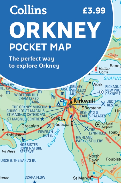
<div> Handy little full colour map of the Orkney Islands in Scotland. Detailed mapping and tourist information for Orkney mainland, Westray, Sanday, Stronsay, Shapinsay, Hoy, South Ronaldsay and the other islands. Excellent value and very detailed for its size.</div> <div> Main features of this map:</div> <div> </div> <div> • Clear mapping at a scale of 2.7 miles to 1 inch</div> <div> • Tourist attractions located and described</div> <div> • Ideal for touring with sights, places to stay, cafe/restaurant, things to do all on the map</div> <div> • Transport links map showing how to get to and depart the islands</div> <div> • Index to places of interest and place names</div> <div> </div> <div> Essential for those planning a trip around the Orkney Isles.</div>
€7,95
Bekijk product
<p> Handige kaart van dit Nationale Park. Goed te gebruiken als overzichtskaart en planningskaart om voor te bereiden wat je waar kunt doen. Op de ene kant een kaart van het park en op de andere zijde een globale kaart met inzetten van de hoogtepunten.</p> <p> Durable and waterproof, with a handy slipcase and an easy-fold format, <b>Lonely Planet's <i>Grand Canyon National Park</i> <i>Planning Map </i></b>helps you get around with ease.</p> <p> Get more from your map and your trip with images and information about top attractions, itinerary suggestions, a transport guide, planning information, themed lists and practical travel tips.</p> <ul> <li> <b>Durable and waterproof </b></li> <li> <b>Easy-fold format and convenient size </b></li> <li> <b>Handy slipcase </b></li> <li> <b>Full color and easy to use </b></li> <li> <b>Before-you-go info</b></li> <li> <b>Beautiful imagery</b></li> <li> <b>Tailored itineraries</b></li> <li> <b>Can't-miss regional highlights</b></li> <li> <b>Detailed town index</b></li> <li> <b>Transport planner</b></li> <li> <b>Themed lists</b></li> </ul> <p> <b>Covers </b>North Rim, North Kaibab Trail, Grand Canyon Lodge, Cape Royal Point, Point Imperial, South Rim, Grand Canyon Village, Desert View Watchtower, Shoshone Point, South Kaibab Trail, Colorado River, Deer Creek Falls, Havasu Canyon, Matkatamiba, Phantom Ranch (Canyon Bottom), Flagstaff, Tuweep</p>
€10,95
Bekijk product
<div> Een degelijke kaart met aanduidingen van o.a. nationale parken, vliegveld, benzinepomp, dirt-roads. Als overzichtskaart goed te gebruiken.</div> <div> </div> <div> This is a brand new title for ITMB, a double-sided map covering the ‘core’ regions of Japan most visited by tourists exploring Japan. Side 1 covers from Tokyo north to Sendai/Nigata and west to Nagoya. Side two covers all of Japan as far as Hiroshima, with insets of the Osaka/Kobe and Kyoto/Nara regions. Naturally, all touristic attractions are noted.</div> <div> </div> <div> Legend Includes:</div> <div> Roads by classification, Rivers and Lakes, National Park, Airports, Points of Interests, Highways, Main Roads, Zoos, Fishing, and much more...</div>
€13,95
Bekijk product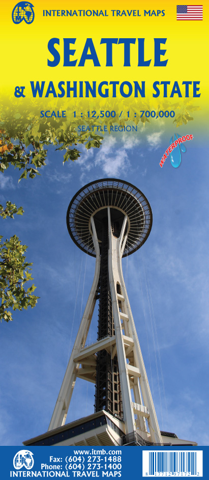
<div> This is a new title for ITMB, in that it is the first time we have mapped the State of Washington. The actual area of the map includes Portland and northern Oregon and Vancouver and the border area with the USA. A small portion of Idaho is also shown. Wilderness campsites, parks such as Rainier, Olympic, and Baker, are shown. Seattle as a city, stretches far beyond the confines of a practical map in that it stretches from Everett to Tacoma. Our map covers from the University in the north to the Beacon Hill neighbourhood in the south and from the waterfront to Lake Washington. An inset map of the greater region is included. The rapid transit line is also included on the map and on the back cover. The reverse side of the sheet shows all the roads of Washington State in excellent Olympic, and Baker, state parks, touristic sites, beaches, ferry routes, native reserves, motorways, and even the ill-fated Hanford nuclear site are included. The map is printed on ITM waterproof paper for durability.</div> <div> </div> <div> Legend Includes:</div> <div> Roads by classification, Rivers and Lakes, National Park, Airports, Points of Interests, Mining, Highways, Main Roads, Zoos, Fishing, , and much more...</div>
€13,95
Bekijk product