
Beantwoord enkele vragen, en binnen seconden geeft AI je een persoonlijk aankoopadvies op maat.
Beantwoord enkele vragen, en binnen seconden geeft AI je een persoonlijk aankoopadvies op maat.

<p> Overzichtskaart van de Kroatische kust van Triest - Istrië in het noorden tot aan de grens van Kroatie (bij plaats Slano) in het zuiden. Veel details en door het prachtige gebruik van de echte zee als achtergrond een mooie kaart om te zien. Op de kaart staan nummers die elders worden beschreven > dit zijn de bezienswaardigheden die je niet moet missen. Havens, stranden en camings staan er op ingetekend, bovendien is de kaart stevig geplastificeerd.</p>
€14,50
Bekijk product
<div> A detailed general map with relief depicted by vivid elevation tinting. The map is indexed and selected location names are written in Arabic as well as standard roman text. Coverage includes neighbouring Tunisia and most of Morocco. Terrain features such as sand deserts, stone deserts, salt flats, water holes and swamps are distinguished, and selected peak heights are indicated. Bathymetric tinting is also applied.</div> <div> </div> <div> Several categories of roads are distinguished, including selected tracks, with intermediate driving distances marked on many routes. Railways, oil and gas piplines, and administrative boundaries are drawn and symbols denote oil and gas production sites, airports, ports, places of worship, campsites, hostels, beach resorts, oases, lighthouses, forts, museums, UNESCO sites and other antiquities and sites of interest. Lines of latitude and longitude are drawn at 1° intervals. The multilingual legend includes English and Arabic. A wallmap version of this map is also available on our website.</div>
€15,95
Bekijk product
<div> Speciale map met daarin een wegenkaart van een Nationale Toerist Route in Noorwegen. Naast een gedetailleerde landkaart van schaal 1: 50.000 met hoogtelijnen en toeristische aanduidingen staat op de achterzijde toeristische informatie, alsmede adressen voor eten, drinken en overnachting.</div> <div> </div> <div> De kaart beschrijft spectaculaire uitzichtpunten, natuurfenomenen, attracties, accommodaties, horeca en bezienswaardigheden langs de Nationale Toeristenweg. De teksten op de kaart zijn drietalig: Noors, Engels en Duits.</div> <div> </div> <div> En elke map is ook nog eens voorzien van 5 XL-ansichtkaarten van het gebied. Als aandenken of om te versturen.</div> <div> </div> <div> <div> This route through constantly changing scenery brings you from lush fjords to stark mountains. The drive through the Ryfylke region is a varied one, with small towns and communities interspersed among flourishing farmland and a versatile business and industrial base. Sauda, which is famous for its smelting industry, is situated between mountain peaks and waterfalls innermost in Ryfylke. In Sauda, and in the old zinc mines of the Allmannajuvet gorge, you can experience Norwegian industrial history first hand. The trip across the Sauda mountains into the Røldal valley is spectacular, along a road that snakes through the towering mountain landscape. Some of Norways most well-known attractions, such as the Prekestolen cliff and plateau (Pulpit Rock), the Lysefjord and the wedged boulder called Kjæragbolten, can be explored on short detours from the route. National Tourist Route Ryfylke runs from Oanes on the Lysefjord, via Sauda to Hordalia in the Røldal valley over a total distance of 183 kilometres (National Road 13, County Road 46/520). The route includes two ferries that offer you a different perspective on the fjord scenery. The stretch from Helandsbygd to Røldal is closed in the winter season. This road usually closes in November and reopens in June.</div> <div> </div> </div> <div> Fakta: - Eksklusiv innpakning - Unikt innhold - Flotte og illustrative bilder - Tre språk(norsk, engelsk og tysk) - Bilder og informasjon rett i kartet - Egne postkort medfølger</div>
€29,95
Bekijk product
<p> Overzichtelijke wegenkaart van heel Grieklenland. Tweezijdig, gedrukt op waterafstotend en scheurvast papier. Met wegnummerng, mooie route-aanduiding, stranden, afstanden tussen steden en dorpen. Daarnaast ook tweetalig uitgevoerd.</p> <div> Detailed and updated map of Greece using G.I.S. (Geographical Information Systems) technology and the WGS84 reference system, and supplemented by a ΕΓΣΑ87 grid. </div> <div> </div> <div> Like all of TERRAIN’s large maps, the map of Greece is printed on Polyart, which is extremely durable against folding and unfolding, does not rip, and is 100% waterproof. </div> <div> </div> <div> Based on field research completed in 2013, this map features all the newest national motorways and their interchanges, toll stations and Motorway Service Stations. </div> <div> </div> <div> Also depicted are Greece’s most important sights, as well as archaeological sites, castles, monasteries, National Parks and scenic routes worth exploring. </div> <div> </div> <div> The map comes in a very practical clear double sleeve. One side contains the removable map, the other a removable booklet with the alphabetical index of cities, villages, archaeological sites and monasteries.</div>
€13,50
Bekijk product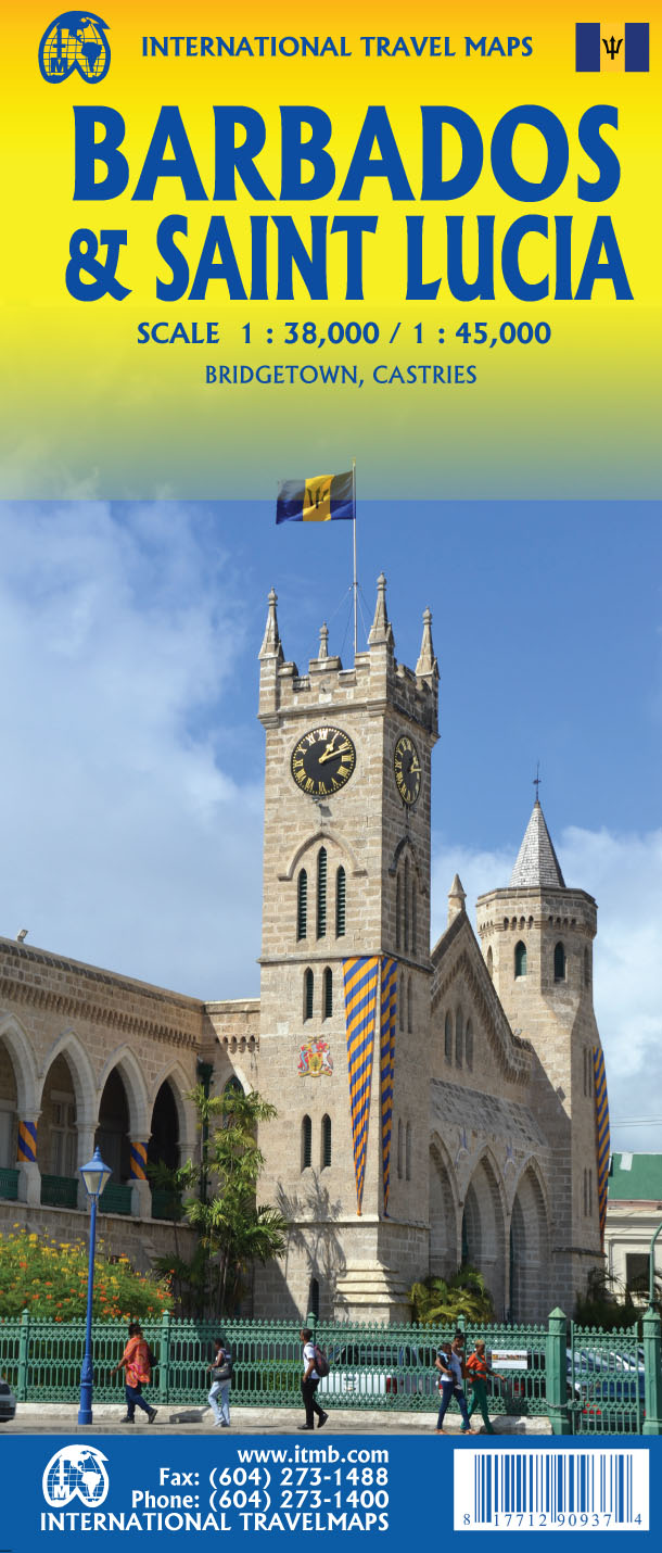
<p> Een degelijke wegenkaart met aanduidingen van o.a. nationale parken, vliegveld, benzinepomp, dirt-roads. Als overzichtskaart goed te gebruiken.</p> <p> Thanks to satellite imagery, we are now able to re-introduce a completely new map of this popular travel destination at an excellent scale, with an inset map of Bridgetown, using our own digital data base files. In addition to showing the roads that criss-cross the island and lead to such interesting villages as Glebe Land, Mile and a Quarter, and Mose Bottom, the map shows all known resort hotels, beaches, dive sites, and historic country manor houses. Barbados is a very friendly island, with its historic capital of Bridgetown providing a ‘touch’ of old Britain, while providing the best shopping in the Caribbean. Printed on paper, single-sided.</p>
€13,95
Bekijk product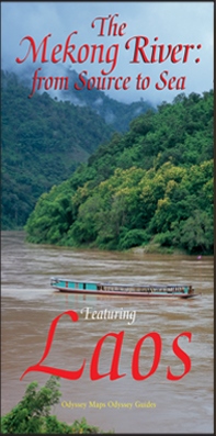
<p> Laos has been discovered. For centuries this land-locked country in southeast Asia was a sleepy, almost forgotten little principality, sometimes wielding great power but mostly fighting for survival against predatory neighbors. It survived the American Indochina War and emerged as a progressive socialist country. This remote, mountainous country, protected from the ravages of tourism and rapid development, remains pristine and exotic. Laos is still green; its rivers mostly run free. But if you want to see the old Laos you have to move fast. Lovely Laos is located at the heart of romantic Indo-Chine. A precious pearl of a country blessed with natural beauty, exotic flora and rare fauna, Laos also hosts the mighty Mekong river for the larger part of its almost 5,000 kilometre journey from the Tibetan Plateau to the distant sea. Whether you chose to travel Laos by land or by water or both, this illustrated map will enhance your journey both as a pre-trip planner and as a post-trip souvenir, and ensure that you see Laos' lesser known attractions whilst pointing you towards the highlights that include the capital Vientiane, the Khone Phapheng Falls, the World Heritage site at Vat Phou, and the fragile gem of the ancient royal capital, Luang Prabang.</p>
€14,95
Bekijk product
<div> Tweetalige kaart (Engels en Duits). Door ingetekende lengte- en breedtegraden is het gebruik van GPS mogelijk. Met hoogtelijnen en uitgebreid wegennetwerk: daarnaast worden ook de afstanden tussen belangrijke plaatsen duidelijk leesbaar weergegeven. Het kleurgebruik is zodanig dat je een goede indruk krijgt van hoogteverschillen en soorten landschap. Natuurlijk staan de toeristische bezienswaardigheden duidelijk vermeld.</div> <div> </div> <div> Gedrukt op water- en scheurvast papier! Polyart is een synthetisch product vrij van giftige stoffen dus duurzaam. Het papier gaat echt lang mee.</div> <div> </div> <div> Topography is indicated by altitude colouring with numerous spot heights and names of mountain ranges and passes. Salt lakes, swamps, seasonal rivers and glacier are also shown. Detailed presentation of the road network includes minor roads and tracks and railways are also shown.</div> <div> </div> <div> Internal administrative units are presented with their boundaries and names. National parks and other protected areas are highlighted. A wide range of symbols mark various places of interest. Map legends include English and all the maps have an index of localities.</div>
€13,95
Bekijk product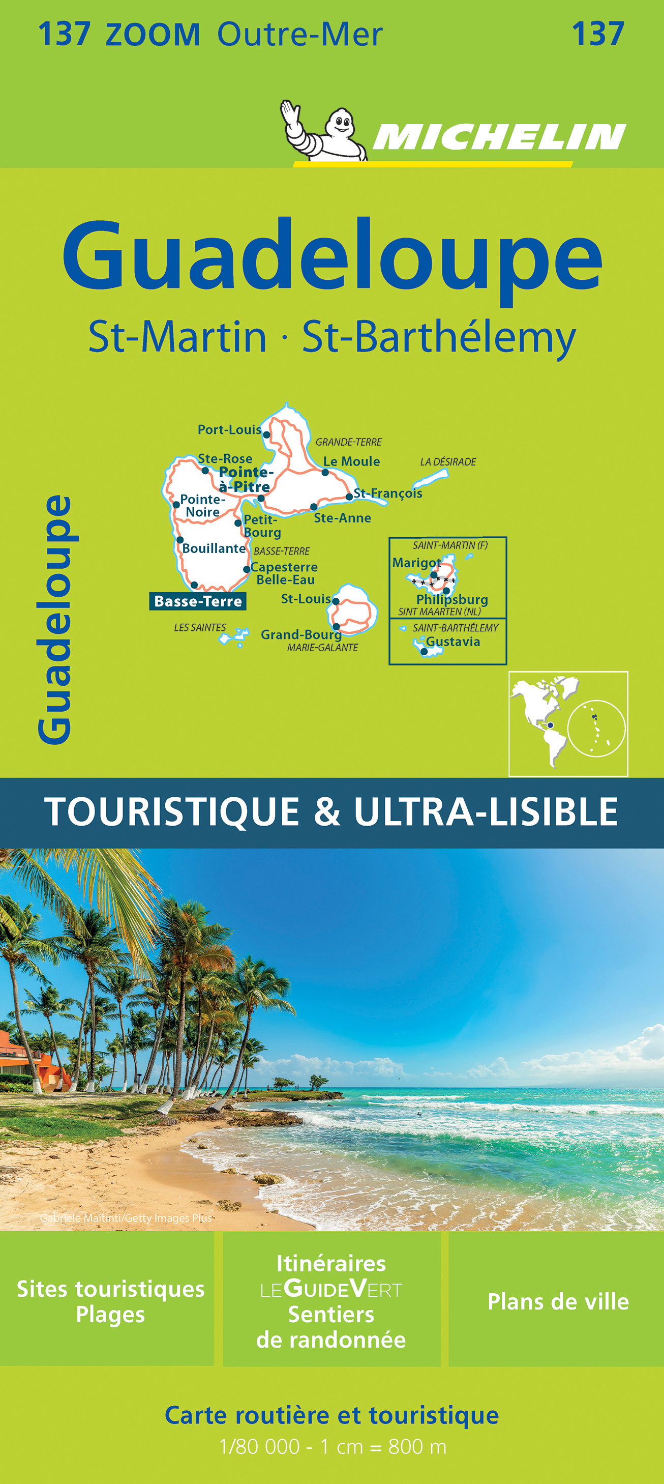
<p> Speciale toeristische kaart, gemaakt voor een goed bezocht gebied en uitvergroot. Daardoor zeer prettig leesbaar met een hoog nivo wat we van Michelin al veel langer gewend zijn. Alle wegen staan er op, met verschillende kleuren voor de aparte soorten wegen. Verder veel aandacht met symbolen voor de bezienswaardigheden in de regio, de bekende groene stroken naast de mooie wegen</p> <p> Chutes du Carbet, Deshales, Guadeloupe, Îlets Pigeon, La Soufrière, Les Saintes, Parc des Mamelles</p>
€10,95
Bekijk product
<div> Tweetalige kaart (Engels en Duits). Door ingetekende lengte- en breedtegraden is het gebruik van GPS mogelijk. Met hoogtelijnen en uitgebreid wegennetwerk: daarnaast worden ook de afstanden tussen belangrijke plaatsen duidelijk leesbaar weergegeven. Het kleurgebruik is zodanig dat je een goede indruk krijgt van hoogteverschillen en soorten landschap. Natuurlijk staan de toeristische bezienswaardigheden duidelijk vermeld.</div> <div> </div> <div> Gedrukt op water- en scheurvast papier! Polyart is een synthetisch product vrij van giftige stoffen dus duurzaam. Het papier gaat echt lang mee.</div> <div> </div> <div> Topography is indicated by altitude colouring with numerous spot heights and names of mountain ranges and passes. Salt lakes, swamps, seasonal rivers and glacier are also shown. Detailed presentation of the road network includes minor roads and tracks and railways are also shown.</div> <div> </div> <div> Internal administrative units are presented with their boundaries and names. National parks and other protected areas are highlighted. A wide range of symbols mark various places of interest. Map legends include English and all the maps have an index of localities.</div>
€13,95
Bekijk product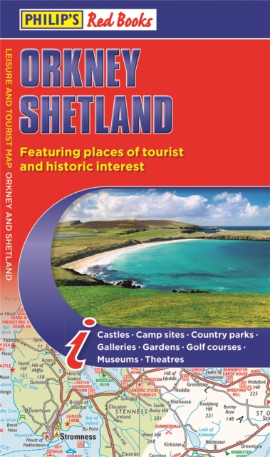
<div> Whether it's the outstanding natural beauty, ancient sites or an activity-packed break calling you, the Philip's leisure and tourist map of Orkney and Shetland is all you need. Places of interest are clearly marked on the easy-to-read mapping - ideal for planning that all-important route.</div> <div> </div> <div> This double-sided Philip's leisure and tourist map of Orkney and Shetland gives detailed coverage of the islands' road networks at an easy-to-read scale of approximately 2.5 miles to 1 inch. The Orkney Islands are featured on side one of the map, with the Shetland Islands shown on the reverse.</div> <div> </div> <div> The maps show places of tourist and historic interest, including beaches, castles, camping sites, distilleries, galleries, gardens, golf courses, museums, nature trails, historic sites, sports and entertainment venues. From the ancient settlement of Orkney's Skara Brae and Scapa Flow to the Shetland Museum and Bobby's Bus Shelter, all the top places of interest are featured on each side of the map for Orkney and Shetland respectively.</div> <div> </div> <div> Easily folded (and unfolded), this double-sided sheet map is ideally suited for both leisure and business use, whether by locals or visitors to the islands.</div>
€11,50
Bekijk product