
Beantwoord enkele vragen, en binnen seconden geeft AI je een persoonlijk aankoopadvies op maat.
Beantwoord enkele vragen, en binnen seconden geeft AI je een persoonlijk aankoopadvies op maat.
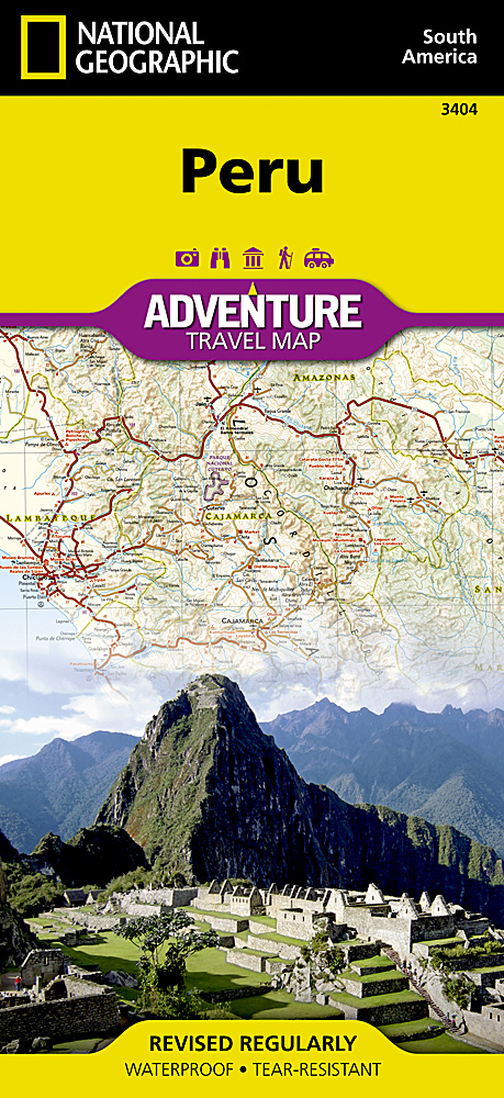
<p> <span style="color: rgb(0, 0, 0); font-family: 'Helvetica Neue', Helvetica, sans-serif, Arial; line-height: 16px;">Wegenkaart van Peru met vermelding van veel bezienswaardigheden, nationale parken en attrakties. Watervast en scheurvast. Juist door deze vermeldingen onderscheidt de kaart zich van andere wegenkaarten.</span></p> <div> National Geographic's Peru Adventure Map is designed to meet the unique needs of adventure travelers—detailed, durable, and accurate. Peru includes the locations of thousands of towns and villages, plus a clearly marked road network complete with distances and designations for highways and roadways. Rough tracks that require four-wheel drive vehicles and paths are included for adventurers seeking to explore more remote regions.</div> <div> </div> <div> What sets National Geographic Adventure Maps apart from traditional road maps are the hundreds of points of interest that highlight the diverse, unique, and exotic destinations within Peru including World Heritage sites, archeological sites, indigenous areas, churches, museums, and more. Users will find a variety of helpful travel aids on our map as well, including the location of airports, airfields, railroads, lighthouses, ferry routes, and harbors. National parks and reserves, beaches, wildlife centers, caves, waterfalls, lodges, scenic viewpoints, and spas are clearly indicated so travelers can take advantage of Peru’s many natural attractions and activities.</div> <div> </div> <div> The front side of the map shows the northern half of Peru including the regions of Loreto, Tumbes, Piura, Amazonas, Lambayeque, Cajamarca, La Libertad, Ancash, Huánuco, and Ucayali. This section of the map spans from Peru’s borders with Ecuador and Colombia on the north and Brazil on the east, down to the coastal city of Chimbote. The regions of Tacna, Puno, Pasco, Moquegua, Madre de Dios, Lima, Junin, Ica, Huancavelica, Cusco, Ayacucho, Arequipa, and Apurímac are included on the reverse side. Provincial and political borders are clearly and accurate marked with colored boundaries, as are the borders of national parks and reserves.</div> <p> </p> <div> </div>
€17,50
Bekijk product
<p> Deze bijzonder gedetailleerde Freytag & Berndt Wegenkaart van Corsica is aan één kant geprint en heeft een schaal van 1:150.000. Op deze kaart staan o.a. fietsroutes, lange afstandswandelpaden, toeristische wegen en bezienwaardigheden aangegeven. In de omslag van de kaart is een apart boekje geniet met een korte beschrijving van de TOP 10 van bezienswaardigheden, een uitgebreide index en plattegrondjes van enkele toeristische plaatsen.</p> <div> Explore the Mediterranean island of Corsica with this Freytag & Berndt single-sided road and leisure map. The best way to plan your trip, prepare your itinerary, and to travel independently on this region. As with all Freytag & Berndt maps, the cartography is clear and detailed with the topography shown with relief shading with plenty of spot heights.</div> <div> </div> <div> This map features a full map of the island. Using Freytag & Berndt's icon system, important tourist information is shown. You will see icons for tourist information such as:</div> <div> </div> <div> Picturesque towns and panoramas</div> <div> Churches, ruins, antique sites and monuments</div> <div> Golf courses, camp sites, and wildlife parks</div> <div> </div> <div> Also included are insets of Corsica's major settlements Ajaccio, Bastia, Corte, Calvi, Porto-Vecchio and Bonifacio. Icons are also used to display information such as public buildings, theatres, casinos, museums, strands and beaches. The legend is in French, German, English, Italian, Dutch, Spanish, Czech, Slovak and Polish.</div> <div> </div> <div> You will also find a helpful booklet featuring the top 10 things to see in Corsica written in German, English, French and Italian; with full colour photographs. An index is also included listing localities along with their postcodes. The top ten are also locatable by icon on the main map.</div>
€14,95
Bekijk product
<p> <span style="font-family: 'Helvetica Neue', Helvetica, sans-serif, Arial; line-height: 16px;">Wegenkaart van </span>Australië Oost <span style="font-family: 'Helvetica Neue', Helvetica, sans-serif, Arial; line-height: 16px;">met vermelding van veel bezienswaardigheden, nationale parken en attrakties. Watervast en scheurvast. Juist door deze vermeldingen onderscheidt de kaart zich van andere wegenkaarten.</span></p> <div> National Geographic's Australia East AdventureMapis designed to meet the unique needs of adventure travelers with its durability and detailed, accurate information. The map includes the locations of thousands of cities and towns with a user-friendly index, plus a clearly marked road network complete with distances and designations for major highways, main roads, plus tracks and trails for those seeking to explore more remote regions. </div> <div> </div> <div> The Australia East AdventureMap differs from a traditional road map because it includes hundreds of points of interest that highlight diverse and unique destinations within the country. National parks, World Heritage sites, caves, archeological sites, aboriginal settlements and protected lands are included, making it an invaluable resource to travelers hoping to experience all the history and culture Australia has to offer. Additional travel aids include the location of airports, lighthouses and ferry routes. </div> <div> </div> <div> The front side of the Australia East map details Queensland, the Great Barrier Reef, and more. The back side of the map details the southern portion of Queensland, including Brisbane, as well as New South Wales and Victoria. An inset map of Tasmania is also included. The Australia AdventureMap is printed in the United States on a durable synthetic paper, making it waterproof, tear-resistant and tough capable of withstanding the rigors of international travel. </div> <div> </div> <div> <div> Key Features:</div> <ul> <li> Waterproof and tear-resistant</li> <li> Detailed topography with clearly labeled natural features</li> <li> Hundreds of points of interest, including the location of World Heritage sites, national parks and nature reserves, aboriginal settlements and protected lands, mines, archeological sites, wildlife parks and more</li> <li> Thousands of place names with a detailed index</li> <li> Important travel aids including airports, lighthouses, ferry routes and rail lines</li> </ul> </div> <p> </p>
€17,50
Bekijk product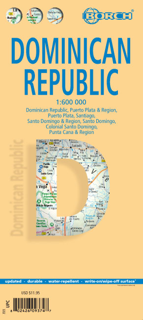
<div> Mooie geplasticieerde kaart van de Dominicaanse Republiek. Deze kaart biedt een goed overzicht van het land met detailkaarten.</div> <div> </div> <div> Our soft-laminated map of the Dominican Republic includes: Dominican Republic 1:600 000, Puerto Plata & Region 1:250 000, Puerto Plata 1:20 000, Santiago 1:17 500, Santo Domingo & Region 1:250 000, Santo Domingo 1:22 500, Colonial Santo Domingo 1:10 000, Punta Cana & Region 1:185 000, Dominican Republic administrative / time zones; interesting statistics: conversion chart for temperatures, weights and measures; climate chart with temperatures, sunshine hours, precipitation and humidity; table of distances; hotels, museums, markets, public transport and much more.</div> <div> </div> <div> Christopher Columbus discovered the island of Hispaniola on December 5th 1492 and founded "La Navidad", said to be the first European settlement in the New World. He became viceroy of Hispaniola and settled in the place where today's capital, Santo Domingo, is situated. During the following centuries, innumerable pirate raids gradually brought the export trade to a standstill, but French colonialists who settled in the west of the island managed to drive them off. Thus, the first independent black republic of the world was founded: République d'Haiti. In 1844 the former Spanish settlers declared their independence from Spain and founded the Dominican Republic. The Dominicans are a very hospitable, open-minded and peace-loving people. Stress and hectic are unknown to them - quite understandable as they are blessed with almost constant holiday temperatures and idyllic surroundings. Travellers are welcome to enjoy the beauty of ca. 1600km (979 miles) of coast, with marvellous palm beaches and snug bays, or the mountains with their lavish profusion of flora and fauna.</div> <div> </div>
€11,50
Bekijk product
<p> Makkelijk leesbare kaart aan 2 zijden bedrukt. De ene kan met informatie en beperkte stadsplattegronden, de andere met de daadwerkelijke kaart. De kaart is geplastificeerd en dus watervast!</p> <p> The front side is an easy-to-read road map covering the states of southern Pennsylvania, southeastern Ohio, West Virginia, Virginia, Kentucky, parts of Illinois and Indiana, Tennessee, North Carolina, South Carolina, Georgia, Florida, Alabama, Mississippi, and parts of Louisiana and Arkansas. There are several inset maps on the front. The back includes: - Information for Shenandoah, Great Smoky Mountains, and Everglades National Parks - Inset maps of New Orleans, Nashville, Orlando, and Miami.</p>
€12,95
Bekijk product
<p> Een degelijke kaart met aanduidingen van o.a. nationale parken, vliegveld, benzinepompen.</p> <p> Finally, we have been able to create our own map of the lovely country of Wales. I use the word ‘country’ in its truest sense, as Wales was invaded and taken over by the English centuries ago. Regardless, the Welsh language and Welsh culture continue to flourish, although English is commonly spoken. We have visited Wales on several occasions and find that the attractions are so numerous that we could never see them all. There are too many castles to count, but some of the best preserved in the British Isles are in Wales, notable Caernarfon, but nearby Harlech is a World Heritage Site. St, David’s must be one of the smallest and loveliest cathedrals in the world, and Tintern Abbey ruins among the most poignant anywhere. We took Johnny to Abergavenny for lunch in March, not that it made any difference; he just pined for a McDonalds. This map is double-sided, with Wales on one side and the West Country (southwest England) graces the other side. Excellent coverage of Cornwall, Devon, and Somerset is provided, along with a fair portion of Dorset and Wiltshire. The eastern extreme of the map is Salisbury/Swindon, so a lot of ground is still being covered. The peculiar way that motorways are designated means that ‘true’ motorways are shown in blue while equally good non-motorways are in green casing, with not a tinker’s difference between them. My own favorite place is Mousehole, on Mount’s Bay; Tintagel ranks a close second. The map is loaded with touristic attractions; both well-known and more local. For something really unusual, visit Hay-on-Wye, west of Hereford. It is actually in England, smack on the border, and its claim to fame is that it is the world’s largest concentration of bookstores – an amazing place! This was obviously a fun map to make, as it includes so many ‘favorite’ places. This map will be invaluable for anyone visiting Wales!</p> <div> Legend Includes:</div> <div> Roads by classification, Motorways, Railways, Attractions, Hotels, Point of interest, Airports, Tourist information, Hospitals, Shopping centre, and much more.</div>
€13,95
Bekijk product
<div> This map ( Scale 1 : 4 000 000 ) includes all of the Caribbean islands - both the Greater and Lesser Antilles, the Virgin Islands and the Bahamas. Central America is covered from the Yucatan and Guatemala through Panama. All of Florida is also depicted, as are the coastal regions of Colombia and Venezuela. The map is detailed as no other map of this region on the market and features, among others, over 100 cruise line ports of call, as well as enlarged insets of the Panama Canal and 36 Caribbean islands.</div> <div> </div> <div> The map is sold folded, measuring 4 7/8" x 8 7/8" (12.5 cm x 22.5 cm) and is designed for easy opening and refolding. Its full unfolded format is 26 3/8" x 38 1/2" ( 67 cm x 98 cm ).</div> <div> </div> <div> It contains the following features</div> <ul> <li> Attractive full color layout;</li> <li> Rich topographic detail;</li> <li> Symbol key and scale;</li> <li> Major cities, main and secondary roads, national and international airports, lighthouses, reefs, national parks, ports, volcanoes, and other places of interest;</li> <li> International boundaries, depth curves, soundings in meters, longitude and latitude lines and other identifiers.</li> </ul>
€14,95
Bekijk product
<p> Goede wegenkaart van een deel van Griekenland. Waar beschikbaar worden hotels en campings getoond en met symbolen worden allerhande toeristische symbolen aangeduid als historische plaatsen, kloosters, museas etc. Tweetalig. Op elke kaart staat van de belangrijkste steden een centrumkaart en er is een behoorlijk uitgebreid register (wel kleine letters!) Kleurgebruik is duidelijk, maar een beetje flets, waardoor hoogteverschillen niet echt goed uitkomen. </p>
€10,25
Bekijk product
<div> Een aangepaste versie van de Duitse provinciekaarten van Freytag & Berndt: duidelijk veel meer toegespitst op de toeristische aspecten van de streek.</div> <div> </div> <div> Deze bijzonder gedetailleerde Freytag & Berndt Wegenkaart van Noordzee & Baltische zee heeft een schaal van 1:150.000. Op deze kaart staan o.a. fietsroutes, lange afstandswandelpaden, toeristische wegen en bezienwaardigheden aangegeven. In de omslag van de kaart is een apart boekje geniet met een korte beschrijving van de TOP 10 van bezienswaardigheden, een uitgebreide index en plattegrondjes van enkele toeristische plaatsen.</div>
€14,95
Bekijk product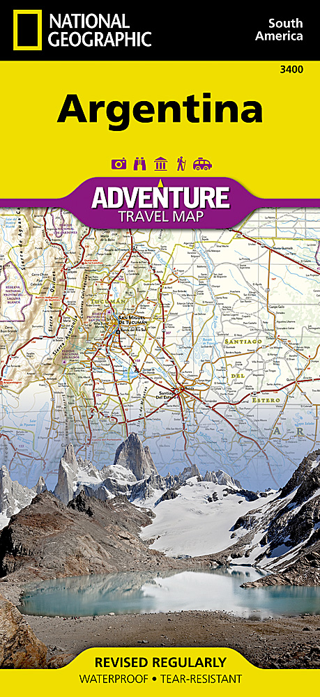
<p> <span style="color: rgb(0, 0, 0); font-family: 'Helvetica Neue', Helvetica, sans-serif, Arial; line-height: 16px;">Wegenkaart van </span>Argentinië<span style="color: rgb(0, 0, 0); font-family: 'Helvetica Neue', Helvetica, sans-serif, Arial; line-height: 16px;"> met vermelding van veel bezienswaardigheden, nationale parken en attrakties. Watervast en scheurvast. Juist door deze vermeldingen onderscheidt de kaart zich van andere wegenkaarten.</span></p> <div> National Geographic's Argentina Adventure Map is designed to meet the unique needs of adventure travelers—detailed, durable, and accurate. Argentina includes the locations of thousands of major cities and towns with an index for easily locating them, plus a clearly marked road network complete with distances and designations for major highways, limited access highways, minor roads, and more.</div> <div> </div> <div> What sets National Geographic Adventure Maps apart from traditional road maps are the hundreds of points-of-interest that highlight the diverse, unique, and exotic destinations within Argentina including national parks and preserves, World Heritage sites, archeological sites, churches of interest, scenic viewpoints, natural points of interest, and important travel aids like airports, airstrips, rail lines, lighthouses, and harbors.</div> <div> </div> <div> The north side of the Argentina map details the most highly populated areas of the country including the provinces of Buenos Aires, Córdoba, and Santa Fe as well as the impressive landscape of the Cordillera de los Andes bordering Chile on the northwest. Vineyards in Mendoza, Argentina’s world-renowned wine producing province are included, as are ski areas in this popular tourist region. An inset map shows the small province of Misiones that juts into the neighboring countries of Brazil and Paraguay. The south side of the map details Argentina’s extensive coastline from Mar Del Plata to Tierra Del Fuego highlighting beaches, preserves, and areas noted for fishing and surfing.</div> <div> </div> <p> </p> <div> Popular places included on the map: Patagonia, Los Glaciares National Park, Península Valdés, Iguazú Falls, Andes Mountains, Puente del Inca, Quebrada de Humahuaca and The Pampas.</div>
€17,50
Bekijk product