
Beantwoord enkele vragen, en binnen seconden geeft AI je een persoonlijk aankoopadvies op maat.
Beantwoord enkele vragen, en binnen seconden geeft AI je een persoonlijk aankoopadvies op maat.

<p> Kaart van Oekraïne met Moldavië, met een uitbreiding met de Krim in meer detail, plus plattegronden van het centrum van Kiev en Lviv. Wegennet is ingedeeld in zes typen, rij-afstanden aangegeven op hoofd-en secundaire routes, en verder worden grensovergangen weergegeven.</p> <p> Ukraine with Moldova on an indexed road map at 1:1,100,000 from Gizi Map, with an enlargement showing southern Crimea in greater detail, plus street plans of central Kiev and Lviv. All place names are shown transliterated into Latin alphabet, with those of major cities also given in their Cyrillic versions.</p> <div> Altitude colouring with relief shading indicates the mountainous regions, with the marshlands of northern Ukraine also marked. National parks and other protected areas are highlighted. Road network is graded into six types, driving distances are marked on main and secondary routes, and border crossings are shown. Railway lines, ferry routes on the Black Sea and Azov Sea, and local airports are included. Symbols highlight various places of interest: historic sites, natural curiosities, etc. Also marked is the location of the nuclear power station at Chernobyl and the surrounding exclusion zone. Latitude and longitude lines are drawn at 1° intervals. Extensive index is on the reverse. Map legend includes English.</div> <div> </div> <div> The map also provides:</div> <div> </div> <div> - an enlargement presenting southern Crimea in greater detail at 1:500,000, including locations of campsites (not shown on the main map for the rest of the country)</div> <div> </div> <div> - street plans of central Kiev and Lviv, annotated with places of interest and tourist accommodation</div>
€15,95
Bekijk product
<p> Tweetalige kaart</p> <div> A folded road map covering covering all of Mongolia, as well as parts of the surrounding countries. Subtle relief shading and spot heights show the topography. Road detail is good including many minor tracks, intermediate road distances are also shown in kilometres on the bigger roads.</div> <div> </div> <div> Various places of interest are marked out including airports, monuments, ruins, administrative boundaries and national parks All place names are written in roman script, with bigger towns also in cyrillic. The extensive index included on the back of the map gives all place names in roman and cyrillic script. </div> <div> </div> <div> An inset showing a street map of the capital, Ulaan Baatar, at 1:30 000 is also included.</div> <div> </div> <div> The legend is in 7 languages including English.</div>
€15,95
Bekijk product
<p> </p> <div> The Caucasus at 1:1,000,000 from Gizi Map, presenting the region in a road edition with relief shading to show its topography and make the road network stand out better against the background. Coverage includes the southern republics of Russia. International boundaries are clearly marked. </div> <div> </div> <div> Within Georgia the map indicates the boundaries of South Ossetia, Abkhazia and Adjara; in Azerbaijan the border of Nagorno Karabach and the ceasefire line are marked. Coverage within Russia extends north of Krasnodar and Stavropol, with boundaries of individual republics including Chechnya, North Ossetia and Dagestan. Place names are shown in Latin alphabet, but within Georgia, Armenia and Russia larger towns are also named in local script.</div> <div> </div> <div> Relief shading with plenty of names of geographical features such as individual mountain ranges, peaks, swamps, salt flats, etc, presents the topography. Road network is graded in six types, with driving distances on main and selected connecting routes. Railway lines are included and local airports are marked. Symbols highlight various places of interest. Latitude and longitude lines are drawn at 1° intervals. The index, arranged by country, is on the reverse. Multilingual map legend includes English.</div> <div> </div> <div> A separate insets presents at-a-glance the political and administrative division of the region.</div>
€15,95
Bekijk product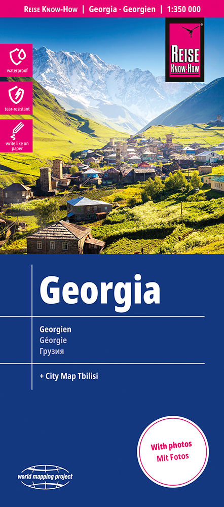
<div> Tweetalige kaart (Engels en Duits). Door ingetekende lengte- en breedtegraden is het gebruik van GPS mogelijk. Met hoogtelijnen en uitgebreid wegennetwerk: daarnaast worden ook de afstanden tussen belangrijke plaatsen duidelijk leesbaar weergegeven. Het kleurgebruik is zodanig dat je een goede indruk krijgt van hoogteverschillen en soorten landschap. Natuurlijk staan de toeristische bezienswaardigheden duidelijk vermeld.</div> <div> </div> <div> Gedrukt op water- en scheurvast papier! Polyart is een synthetisch product vrij van giftige stoffen dus duurzaam. Het papier gaat echt lang mee.</div> <div> </div> <div> Topography is indicated by altitude colouring with numerous spot heights and names of mountain ranges and passes. Salt lakes, swamps, seasonal rivers and glacier are also shown. Detailed presentation of the road network includes minor roads and tracks and railways are also shown.</div> <div> </div> <div> Internal administrative units are presented with their boundaries and names. National parks and other protected areas are highlighted. A wide range of symbols mark various places of interest. Map legends include English and all the maps have an index of localities.</div>
€15,95
Bekijk product
<div> <div> Tweetalige kaart (Engels en Duits). Door ingetekende lengte- en breedtegraden is het gebruik van GPS mogelijk. Met hoogtelijnen en uitgebreid wegennetwerk: daarnaast worden ook de afstanden tussen belangrijke plaatsen duidelijk leesbaar weergegeven. Het kleurgebruik is zodanig dat je een goede indruk krijgt van hoogteverschillen en soorten landschap. Natuurlijk staan de toeristische bezienswaardigheden duidelijk vermeld.</div> <div> </div> <div> Gedrukt op water- en scheurvast papier! Polyart is een synthetisch product vrij van giftige stoffen dus duurzaam. Het papier gaat echt lang mee.</div> <div> </div> <div> Topography is indicated by altitude colouring with numerous spot heights and names of mountain ranges and passes. Salt lakes, swamps, seasonal rivers and glacier are also shown. Detailed presentation of the road network includes minor roads and tracks and railways are also shown.</div> <div> </div> <div> Internal administrative units are presented with their boundaries and names. National parks and other protected areas are highlighted. A wide range of symbols mark various places of interest. Map legends include English and all the maps have an index of localities.</div> </div> <div> </div>
€11,50
Bekijk product
<div> Tweetalige kaart (Engels en Duits). Door ingetekende lengte- en breedtegraden is het gebruik van GPS mogelijk. Met hoogtelijnen en uitgebreid wegennetwerk: daarnaast worden ook de afstanden tussen belangrijke plaatsen duidelijk leesbaar weergegeven. Het kleurgebruik is zodanig dat je een goede indruk krijgt van hoogteverschillen en soorten landschap. Natuurlijk staan de toeristische bezienswaardigheden duidelijk vermeld.</div> <div> </div> <div> Gedrukt op water- en scheurvast papier! Polyart is een synthetisch product vrij van giftige stoffen dus duurzaam. Het papier gaat echt lang mee.</div> <div> </div> <div> Topography is indicated by altitude colouring with numerous spot heights and names of mountain ranges and passes. Salt lakes, swamps, seasonal rivers and glacier are also shown. Detailed presentation of the road network includes minor roads and tracks and railways are also shown.</div> <div> </div> <div> Internal administrative units are presented with their boundaries and names. National parks and other protected areas are highlighted. A wide range of symbols mark various places of interest. Map legends include English and all the maps have an index of localities.</div>
€11,50
Bekijk product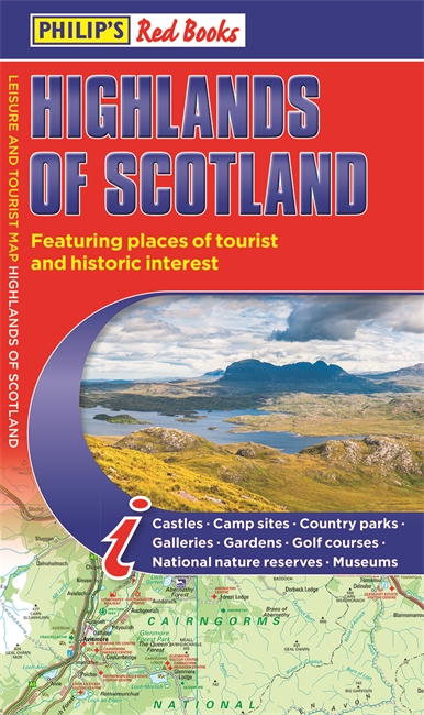
<p> Zeer duidelijke wegenkaart van het noorden van Schotland.</p> <p> This leisure and tourist map of the Highlands of Scotland gives detailed coverage of the area's road network at a scale of 4.34 miles to 1 inch. The map shows places of tourist and historic interest, including castles, camping sites, country parks, galleries, gardens, golf courses, marinas, museums, nature trails, historic sites, sports venues, theatres, theme parks, wildlife parks and zoos. An index to principal places of interest is also featured. In a convenient folded format, this single-sided sheet map is ideally suited for both leisure and business use, whether by locals or visitors.</p>
€9,95
Bekijk product
<div> Een degelijke wegenkaart met aanduidingen van o.a. nationale parken, vliegveld. Als overzichtskaart goed te gebruiken.</div> <div> </div> <div> Legend Includes:</div> <div> Roads by classification, Rivers and Lakes, National Park, Airports, Points of Interests, Mining, Highways, Main Roads, Zoos, Fishing, , and much more...</div>
€13,95
Bekijk product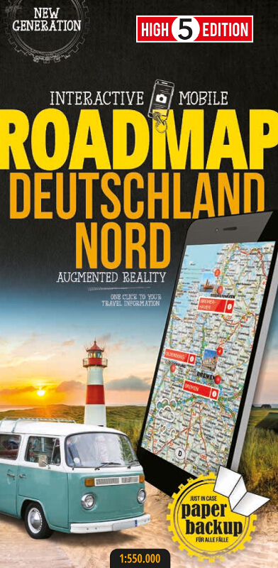
<div> The first water-resistant roadmap with direct access to useful additional information from the Internet</div> <div> </div> <div> Northern Germany in a scale of 1:550,000 shown on a practical map; inclusive of the High 5 Edition app technology for calling up additional travel information and many other benefits:</div> <div> </div> <ul> <li> practical format (11.4 x 23.5 cm)</li> <li> it is water-resistant (laminated/cellophane coating)</li> <li> contains a selection of the local index including postal codes; the entire index can be viewed using the QR-code</li> </ul> <div> It doesn’t matter what weather it is used in or how often it is folded, the condition of the “ROADMAP Germany North” will not deteriorate. Roads, ascents, woodland and mountain areas are easily recognisable thanks to the clear layout of the map. There is also a brief informative section about Germany (speed limits, area codes, emergency numbers, etc.)</div> <div> </div> <div> The “Interactive Mobile ROADMAP Germany North” – a “paper backup” just in case...</div> <div> ... and when used in conjunction with a smartphone, it is a great tool for planning trips.</div> <div> </div> <div> What’s not on the map is in the app</div> <div> By scanning the section of the map you want with the High 5 Edition app, you can get a lot of useful additional information about major attractions and cities in Northern Germany. The app is based on Augmented Reality technology and is available free of charge from the Apple App store and Google Play store.</div>
€12,95
Bekijk product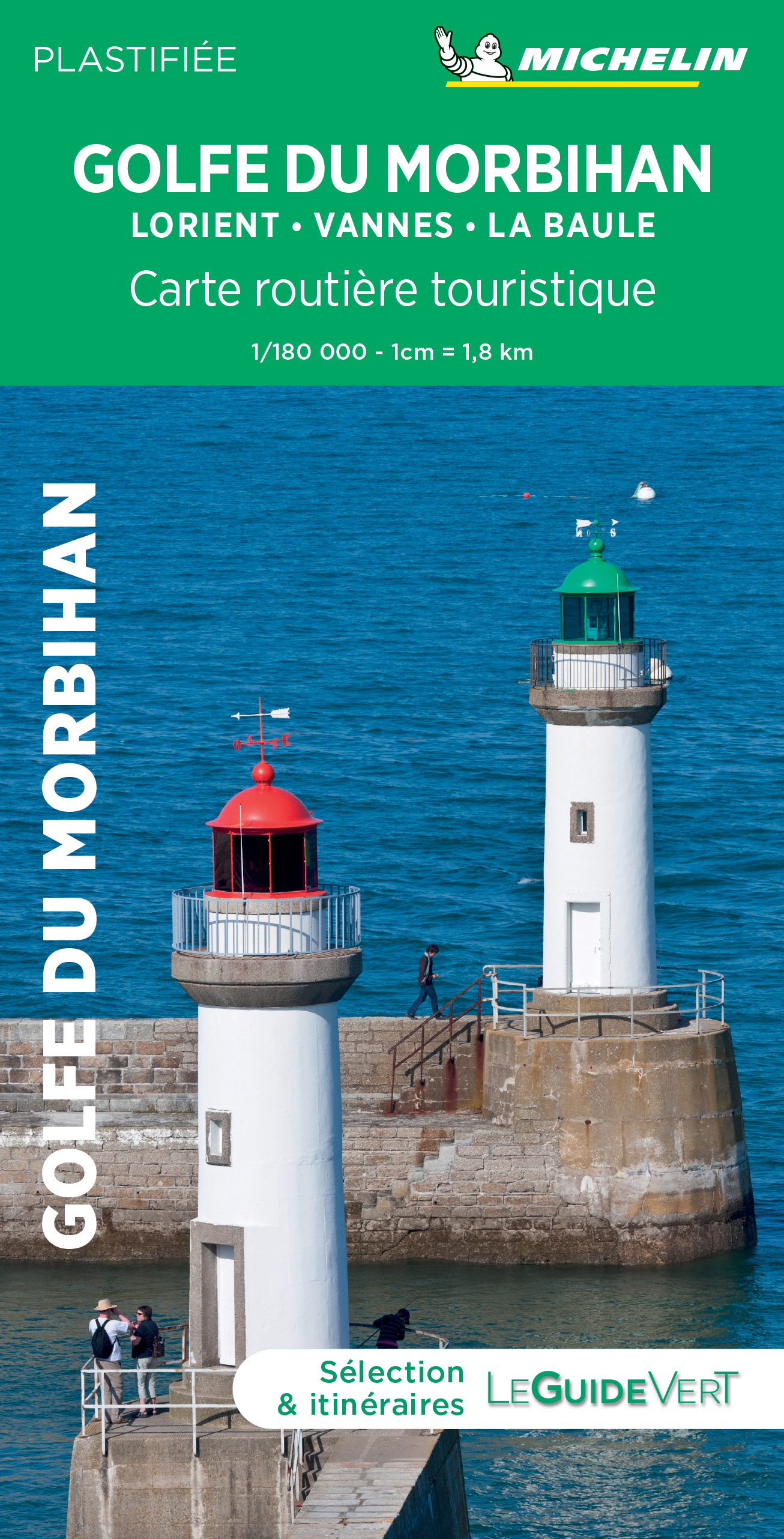
<p> Toeristische wegenkaart van een deel van Fraknrijk. Op de ene zijde een een Michelin kaart afgebeeld op een schaal van ca. 1:200.000, het gaat hier om de originele Michelin wegenkaart met alle postieve aspecten die hier bij horen: duidelijk kaarttbeeld met toch veel detail. Daarnaast enkele plattegronden (het centrum) van de belangrijkste steden in dat gebied. Op de achterzijde (in het Frans) vindt u beknopt de hoogetepunten beschreven van de streek met leuke dingen om te doen of te zien.</p> <p> Deze kaart is gedrukt op speciaal papier en is daardoor scheur- en watervast: een duurzame kaart!</p> <p> Belfort, Besançon, Golfe du Morbihan Lorient-Vannes-La, Jura, Lons-le-Saunier, Nantua</p>
€10,50
Bekijk product