
Beantwoord enkele vragen, en binnen seconden geeft AI je een persoonlijk aankoopadvies op maat.
Beantwoord enkele vragen, en binnen seconden geeft AI je een persoonlijk aankoopadvies op maat.
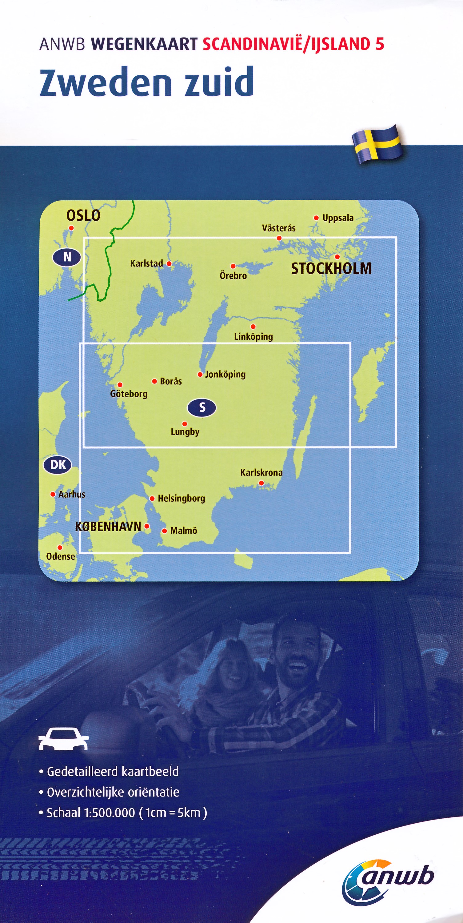
<div> De ANWB heeft een grote serie wegenkaarten van de belangrijkste landen en streken. Het zijn echte overzichtskaarten van vaak een wat groter gebied. Deze keuze zorgt er voor dat de schaal vrij grof is en bepaalde details zijn weggelaten. De kleurstelling is een beetje flets waardoor je niet altijd even makkelijk onderscheid kan maken tussen verschillende landschappen of natuurlijke aspecten. </div> <div> Ook het register ontbreekt. Het grote voordeel is vaak dat het gebied op de kaart overeenkomt met de vraag van klanten. Voor het plannen van een vakantie een prima kaart!</div> <div> </div> <div> Vergelijken met andere uitgevers van kaarten als Michelin, Freytag und Berndt of Reise KnowHow heeft de ANWB duidelijke keuzes gemaakt en gekozen voor een echte overzichtskaart. </div>
€12,99
Bekijk product
<p> Gedetailleerde, eenzijdige landkaart van de Duitsland. De berijdbare wegen zijn goed weergeven, zowel de hoofdwegen als provinciale en lokale wegen; wegnummers worden vermeld. Afstanden tussen plaatsen zijn in kilometers op de kaart ingetekend, daarnaast worden ook op belangrijke plekken benzinepompen gemarkeerd.</p> <p> In het kaartbeeld wordt door middel van schaduw het reliëf weergegeven en soms enkele punten in het landschap met de daadwerkelijke hoogte. Provinciegrenzen zijn goed terug te vinden, nationale parken en reservaten ook. Met allerhande symbolen worden toeristische bezienswaardigheden weergegeven als monumenten, historisch belangrijke plekken en uitzichtpunten. In bepaalde plaatsen zijn hotels en campings te vinden, luchthavens, treinverbindingen en havens vindt u er ook op!</p> <p> <span style="font-family: Arial, Helvetica, sans-serif; line-height: 14px; text-align: left; ">Germany at 1:700,000 on a large, single-sided road map from Freytag & Berndt, with a separate extensive index booklet listing locations with postcodes and providing street plans of 18 town centres in the country’s main cities. The map shows the country’s road network, clearly distinguishing motorways and main connecting routes, shown with driving distances, from local roads. Motorway interchanges are named and services are marked. Railway lines are included. Topography is indicated by relief shading with plenty of names of geographical features such as mountain and hill ranges, woodlands, regional parks and other protected areas, etc. Small symbols indicate locations of castles and other historical buildings and monuments, but the map is not primarily designed to show tourist information. Latitude and longitude lines are drawn at 30’ intervals. Multilingual map legend includes English. Extensive index is in a separate booklet attached to the map cover and lists locations with their postcodes. The booklet also includes street plans of central Berlin, Bremen, Cologne, Dresden, Düsseldorf, Erfurt, Frankfurt, Hamburg, Hannover, Kiel, Leipzig, Magdeburg, Mainz, Munich, Potsdam, Saarbrücken, Schwerin, Stuttgart and Wiesbaden</span></p>
€14,95
Bekijk product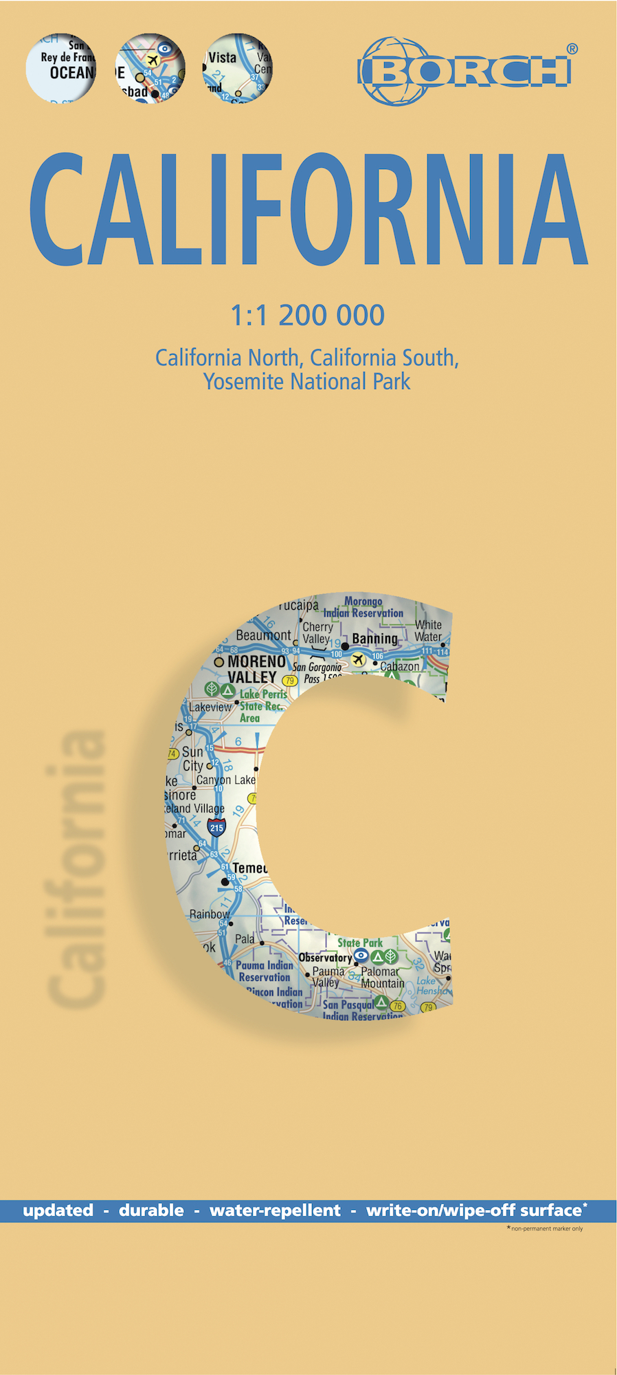
<div> <span style="color: rgb(0, 0, 0); font-family: 'Helvetica Neue', Helvetica, sans-serif, Arial;">Mooie geplasticieerde kaart van Californië. Deze kaart biedt een goed overzicht van dit deel van de Verenigde Staten met detailkaarten.</span></div> <div> </div> <div> Our soft-laminated folded map of California shows: California North 1:1 200 000, California South 1:1 200 000, Yosemite National Park 1:675 000, USA administrative and time zones. Borch Maps are easy to fold, durable and water-repellent with a wipeable surface. Borch Maps show hotels, museums, monuments, markets, public transport, top sights and points of interest, useful statistics, conversion charts for temperatures, weights and measurements, climate charts showing temperatures, sunshine hours, precipitation and humidity, overview maps, time zones, and much more...</div> <div> </div> <div> Mountains, ocean, forest, desert - California has everything to offer the visitor. And in Los Angeles, anything is possible: lying on Venice Beach in the morning, skiing in the nearby San Gabriel Mountains in the afternoon, a visit to Disneyland, an exciting tour through Universal Studios, a glimpse of the homes of the rich and famous in Beverly Hills, reminiscing the golden days of Hollywood on the Walk of Fame. But there is still so much more to see and experience, such as San Francisco, Palm Springs, and San Diego with its 112 km of beachfront almost within arm's reach of the Mexican border. Death Valley is the greatest natural attraction and the hottest area in the U.S., boasting spectacular canyons and rock formations. Those who prefer a more moderate climate will enjoy the laid back atmosphere of California's beautiful coastal towns, such as Monterey and Santa Barbara.</div> <div> </div>
€11,50
Bekijk product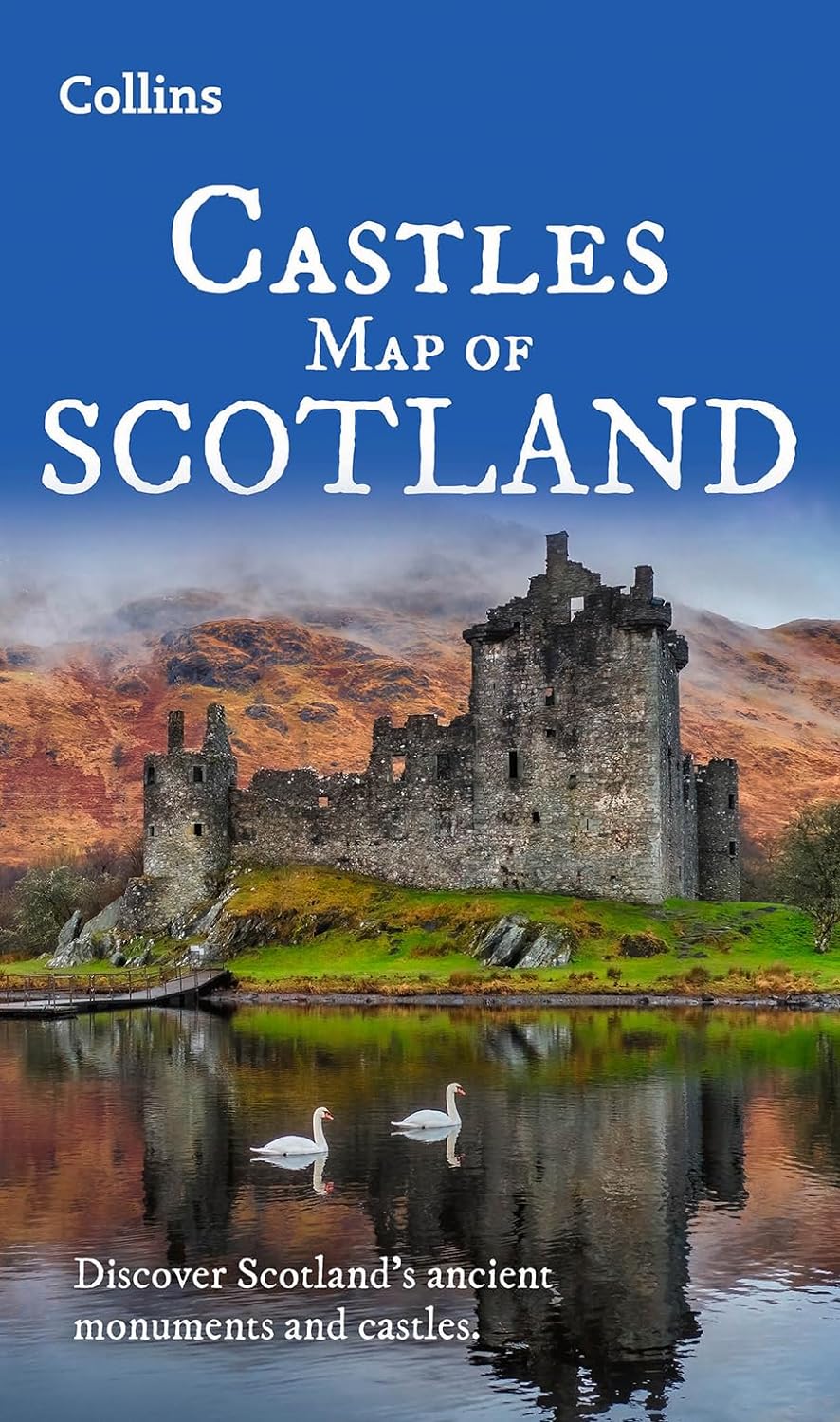
<p> Kaart waarop meer dan 700 kastelen in Schotland staan aangegeven.</p> <div> <div> Discover Scotland's ancient monuments and castles.</div> <div> Explore Scotland’s ancient monuments with this pictorial map featuring over 700 castles and fortified houses. Includes an easy-to-use index listing visitor information and an attractive selection of photographs.</div> <div> </div> <div> The map includes:</div> <div> • Over 700 castles and fortications</div> <div> • Index comprises map references, the age and type of each castle, public access details, Historic Scotland and National Trust for Scotland ownership, notable grounds and gardens, telephone numbers and websites</div> <div> • Highlights Scotland’s finest castles, castellated mansions and also the best castles for children</div> <div> • Attractive photographs of a selection of castles, together with a brief account of their history</div> <div> • A brief history of Scottish castles and information on architectural types and periods of construction</div> <div> • Internet links and suggested reading for further information</div> <div> </div> <div> Scotland is a country as rich in castles and fortified houses as any other in Europe – this map is a guide to them</div> <div> </div> <div> Other titles in the series include:</div> <div> Tartans Map of Scotland</div> <div> Scotland of Old Map Clans Map</div> <div> Whisky Map of Scotland</div> </div> <p> </p>
€13,95
Bekijk product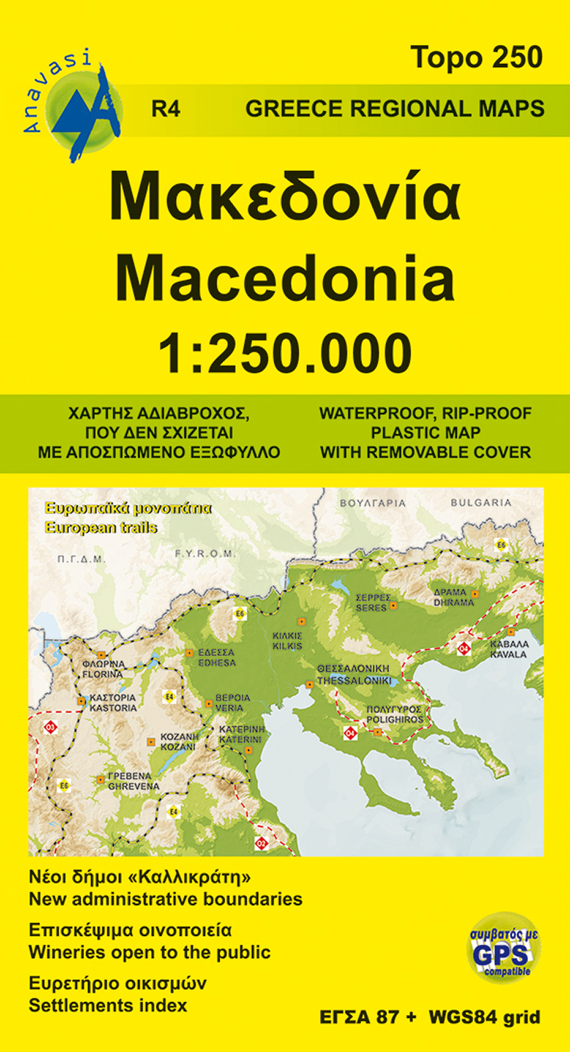
<p> Gedetailleerde tweetalige (Grieks/Engels) topografische wegenkaart van Griekse Macedonië met hoogtelijnen, relief, gedetailleerd wegennet met wegnummers, campings en hutten. Met ingetekende Europese en nationale lange afstandswandelpaden.</p> <p> Anavasi Regional Maps series (Topo250), covering half of the mainland from Konitsa to Katerini in the north and from Messolongi to Thiva in the south. The map comprises all the new highways, the protected areas and Natura sites, the european and national long distance trails and a 84 pages index of settlements, mountains and mountain refuges.</p> <p> Double-sided roadmap and place name index, GPS compatible regional road maps printed on waterproof and tear-resistant plastic paper</p>
€11,95
Bekijk product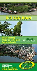
<p> Goede uitgebreide landkaart van het grensgebied Nicaragua en Costa Rica met informatie over musea, natuurgebieden, pompstations, hotels etc. en met stadsplattegronden</p> <p> Managua tot Rivas op schaal 1:150.000, stadsplattegronden van San Carlos, El Castillo , San Juan de Nicaragua, plattegrond Boca de Sabalos</p>
€11,75
Bekijk product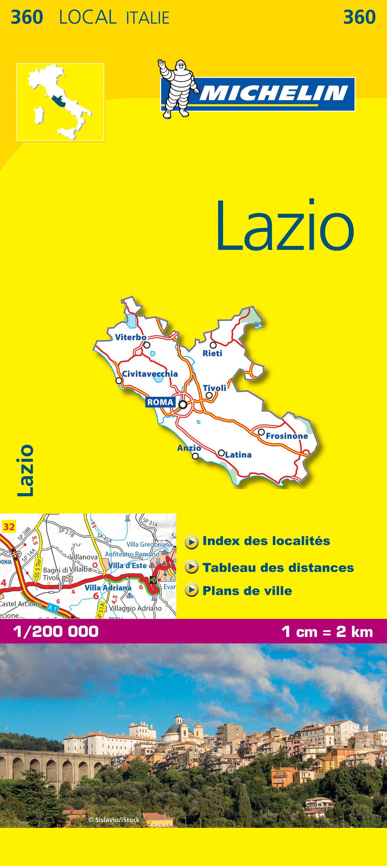
<div> De Michelin kaart is actueel, gedetailleerd, nauwkeurig, praktisch en internationaal. </div> <div> </div> <div> De Lokale Michelin streekkaart biedt u: nauwkeurige en toeristische informatie over een streek of regio, een plaatsnamenregister om uw route gedetailleerd uit te stippelen, een nog waarheidsgetrouwere weergave van de topografie door het satellietbeeld en een selectie van de mooiste plekken.</div> <div> </div> <div> From Michelin's yellow Local series of Europe maps comes this map of Lazio - Latium at 1:200 000, showing excellent detail in this region of Italy. The map has the usual excellent road detail characteristic of Michelin maps, with everything from motorways down to rough tracks and footpaths marked out clearly. The number of lanes is indicated on most roads, with intermediate road distances, European route numbers and tolled roads also shown.</div> <div> </div> <div> The map includes highly detailed relief shading that's derived from satellite photos, with plenty of spot heights also. View points, scenic routes, religious and historic buildings, caves, palaces and villas, parks and loads of other places of touristic interest are marked out with symbols. The legend is in a few lanaguages, one of them is English.</div> <div> </div> <div> The map also has a table gving distances and driving times between major towns and citites throughout the region and an extensive index of places.</div> <div> </div> <div> Italie, Latium, Rieti, Rome, Tivoli</div>
€10,95
Bekijk product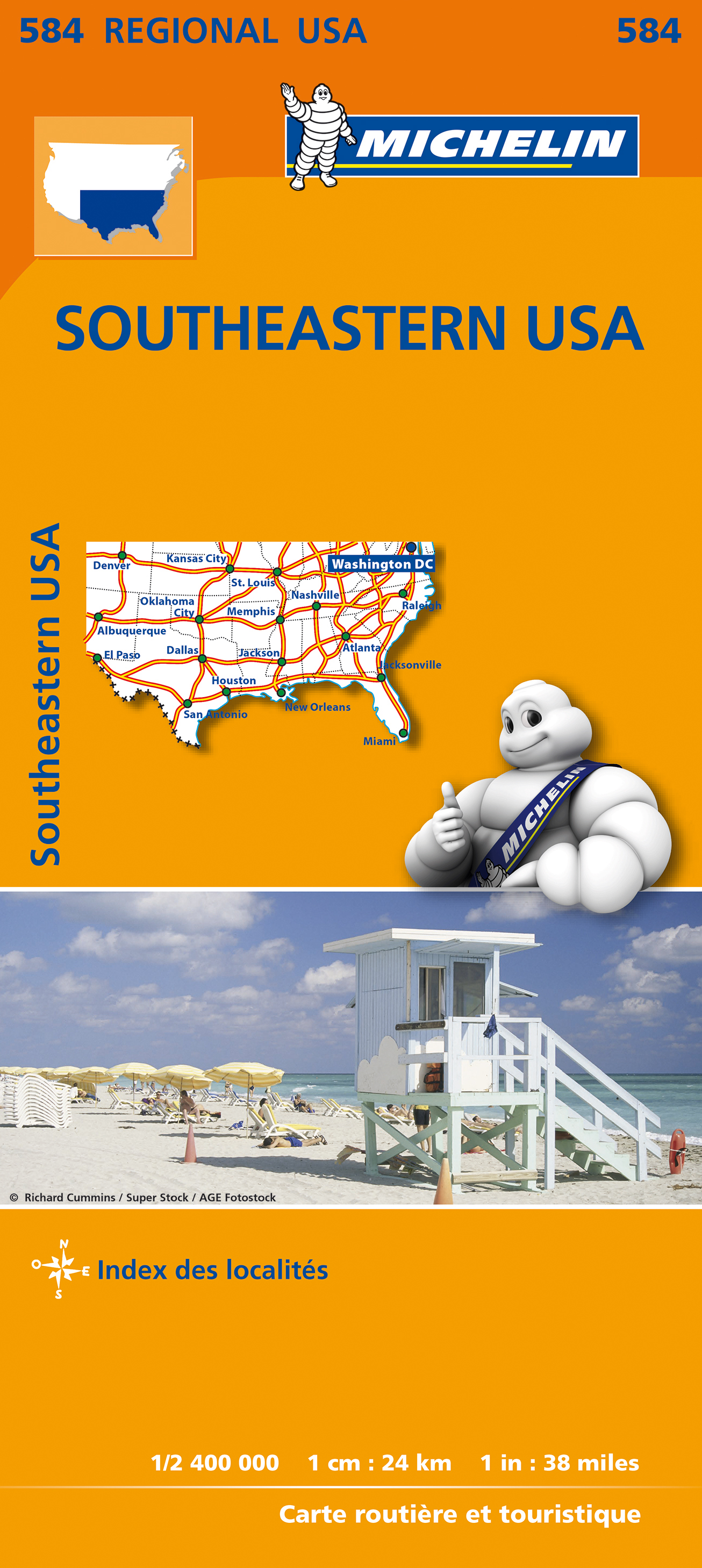
<p> Wegenkaart van zuidoostelijk Amerika (zuid vanaf Torreon en Saltillo, west El Paso en Albuquerque, noord in een lijn van Denver naar Washington DC.</p> <div> Primary & secondary road networks are clearly marked out with indications of the number of lanes, intermediate distances and various possible road obstacles or things you should know including steep hills, height limits, toll barriers, prohibited roads and roads subject to restrictions.</div> <div> </div> <div> The map also includes small insets with street plans of the regions major towns, showing road names, one way streets and various places of interest (tourist sights, hospitals, parking, railway stations, etc.). Scenic routes on the map are marked out in green and an extensive index of place names is included.</div> <div> </div> <div> The map also features:</div> <div> </div> <div> Administrative boundaries</div> <div> Railways, Airports and Ferry Services</div> <div> Important sights such as castles, ruins, and churches</div> <div> Driving Times and Distance Charts</div> <div> Road Safety Information</div> <div> A legend in multiple languages, including English</div> <div> </div> <div> Arkansas, Caroline du Nord, Caroline du Sud, Floride, Géorgie (USA), Kansas, Kentucky, Louisiane, Mississippi, Missouri, Oklahoma, Sud-Est américain, Tennessee, Texas</div>
€12,95
Bekijk product
<p> Our new Costa Rica map is ready and it´s fantastic. It´s the best map of Costa Rica available on the market. With detailed maps for:</p> <p> Citymap San Jose 1: 12.500<br /> detailed map of Central Valley 1:75.000 - NO OTHER MAP HAS THIS DETAILED mAP eine andere Karte bietet so etwas<br /> Vulkan Poas 1:50.000<br /> Vulkan Arenal 1:50.000<br /> Nationalpark Tortuguero 1:50.000</p> <p> </p>
€11,75
Bekijk product
<p> Our new Chile map is ready and it´s fantastic. It´s the best map of Chile available on the market.</p> <p> Highlights are:</p> <p> important and historic sites, museums and other important places<br /> all the nature reserves<br /> advices for ornithologists and botanicans<br /> exact distance kilometers, fuel stations, hotels, panoramic routes for self drivers<br /> some of most important local folk festivals</p>
€11,75
Bekijk product