
Beantwoord enkele vragen, en binnen seconden geeft AI je een persoonlijk aankoopadvies op maat.
Beantwoord enkele vragen, en binnen seconden geeft AI je een persoonlijk aankoopadvies op maat.

<p> <span style="font-size: 12px;">De kaart is dubbelzijdig, heeft enkele stadsplattegronden van de meest bekende steden en er is een register bij.</span></p> <p> Goede duidelijke wegenkaart aan twee kanten bedrukt. Wel een grote lap kaart, maar daardoor bestrijkt het een groot gebied. Alle toeristische details staan er op, ook campings worden vermeld.</p> <p> Gedetailleerde, tweezijdige landkaart, prima geschikt voor planning en rondtrekken. De berijdbare wegen zijn goed weergeven, zowel de hoofdwegen als provinciale en lokale wegen; wegnummers worden vermeld. Afstanden tussen plaatsen zijn in kilometers op de kaart ingetekend, daarnaast worden ook op belangrijke plekken benzinepompen gemarkeerd.</p> <p> In het kaartbeeld wordt door middel van schaduw het reliëf weergegeven en soms enkele punten in het landschap met de daadwerkelijke hoogte. Provinciegrenzen zijn goed terug te vinden, nationale parken en reservaten ook. Met allerhande symbolen worden toeristische bezienswaardigheden weergegeven als monumenten, historisch belangrijke plekken en uitzichtpunten. In bepaalde plaatsen zijn hotels en campings te vinden, luchthavens, treinverbindingen en havens vindt u er ook op!</p> <p> </p>
€14,95
Bekijk product
<p> Uitstekende wegenkaart waarbij de Europese kleurstelling de kaart zeer prettig leesbaar maken i.v.m. met Amerikaanse kaartenmakers. Deze kaart is eenzijdig bedrukt. Op de kaart is informatie te vinden waar allerlei voorzieningen te vinden zijn (d.m.v. symbolen), zoals campings, picknickplaatsen, informatiecentra, luchthavens enz. Bij de kaart zit een apart boekje met een aantal kleine stadsplattegronden, informatie over Nationale Parken en overige informatie voor toeristen.</p> <p> Met Maine, New Hampshire, Vermont, New York, Massachusetts, Rhode Island, Connecticut, Pennsylvania, New Jersey and large Maryland and Delaware.</p> <p> <span style="font-size: 12px;">These new, region by region "USA Road Guides", on a scale of 1 : 1 mio, provide up-to-date, detailed road maps with lots of tourist information. Transit and city maps, as well as detailed maps of national parks, are included in the map layout. The map package also includes a mileage chart with travelling times between major cities, and a brochure with an index of places, travel information from A to Z, top attractions and travel tips.</span></p> <p> <strong><span style="font-size: 12px;">Plaatsen op de kaart</span></strong><br /> Ottawa, Montreal, Québec, Houlton, Bangor, Acadia N.P., Portland, Concord, Boston, Providence, New York, Albany, Syracuse, Watertown, Buffalo, Niagara Falls Niagara watervallen, Toronto, Harrisburg, Philadelphia, Atlantic City, Washington D.C., Pittsburgh, Cleveland.<br /> </p>
€14,95
Bekijk product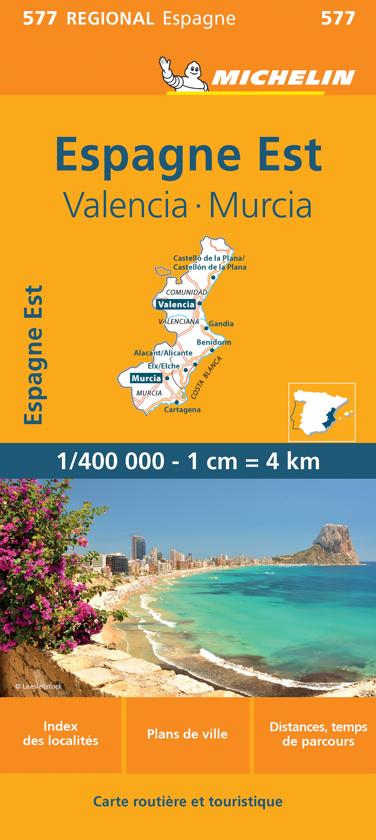
<div> Zoals je van Michelin mag verwachten zijn het onmisbare overzichtskaarten van een uitstekende kwaliteit: een duidelijk en goed leesbaar kaartbeeld. Vrijwel alle berijdbare wegen staan er op ingetekend, in kleur verschillend voor grote en kleine wegen. Andere weginformatie omvat bijvoorbeeld kilometer-afstanden, tolwegen, helling-aanduiding, winterafsluitingen, tankstations maar ook de bekende groene routes: de mooiste wegen om te rijden.</div> <div> </div> <div> Daarnaast geeft de kaart toeristische informatie met symbolen weer: bezienswaardigheden als kastelen, kloosters, musea, maar ook campings (niet allemaal overigens). De kaart is voorzien van een 4-talige legenda.</div> <div> </div> <div> Toch hebben de makers door een beperkt gebruik van symbolen geen drukke kaart gemaakt. De kracht zit hem dan ook in de combinatie van meer dan voldoende informatie en goede leesbaarheid. </div> <p> <span style="font-size: 12px;">Part of the orange regional series from Michelin, this Comunidad Valenciana, Murcia map shows this part of Spain in excellent detail. Primary & secondary road networks are clearly marked out with indications of the number of lanes, intermediate distances and various possible road obstacles or things you should know including steep hills, height limits, toll barriers, prohibited roads and roads subject to restrictions.</span></p> <div> </div> <div> The map also includes small insets with street plans of Valencia, Alacant/Alicante and Murcia, showing road names, one way streets and various places of interest (tourist sights, hospitals, parking, railway stations, etc.). Scenic routes on the map are marked out in green and an extensive index of place names is included.</div> <div> </div> <div> The map also features:</div> <div> </div> <div> Administrative boundaries</div> <div> Railways, Airports and Ferry Services</div> <div> Important sights such as castles, ruins, and churches</div> <div> Driving Times and Distance Charts</div> <div> Road Safety Information</div> <div> A legend in multiple languages, including English</div> <div> </div> <div> Communauté Valencienne, Espagne, Murcie, Valence</div> <p> </p>
€11,95
Bekijk product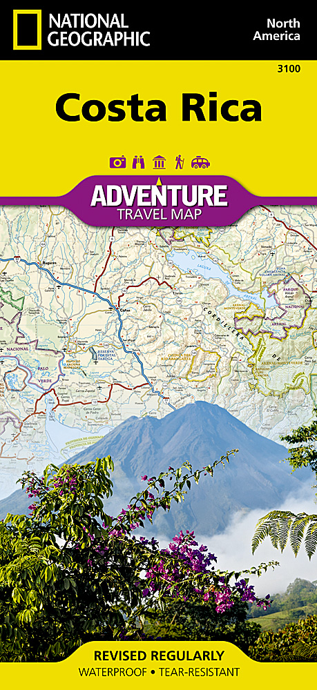
<p> Zeer gedetailleerde kaart van Costa Rica met stadsplattegrond van de hoofdstad van Costa Rica. Misschien wel de beste kaart! Gedrukt op scheur- en watervast papier.</p> <p> Double-sided, waterproof, tear-resistant and with a street plan of central San José, the NGS Costa Rica Adventure Map was produced in cooperation with the Instituto Geográfico Nacional, Costa Rica’s national survey organization.</p> <p> The country is divided east/west, with a generous overlap between the two sides. Topography is shown by contours at 100m intervals, enhanced by relief shading and spot heights. Along the coast reefs, rocks and shallow water areas are marked. The map indicates various types of vegetation: forests, palm forest, mangrove, and fresh or salt water swamps. Road network includes gravel tracks and indicates roads passable only in summer. Railways and local airstrips are marked, as well as the country’s internal administrative boundaries together with names of the provinces.</p> <p> The map highlights seven different types of protected areas: national wildlife refuges, protection zones, wetlands, national parks, forest reserves, biological reserves, and absolute nature reserves, plus national monuments, all listed in a special index. A UTM grid is printed on the map, plus latitude and longitude margin ticks at 10' intervals.</p> <p> The map includes a street plan of central San José, naming principal streets and districts, and highlighting various places of interest to visitors. Also included are enlargements for Isla del Coco, Isla del Caño, an overview map of Central America, and an index of selected towns.</p> <p> </p>
€17,50
Bekijk product
<p> Gedetailleerde, tweezijdige landkaart van Peru, prima geschikt voor planning en rondtrekken. De berijdbare wegen zijn goed weergeven, zowel de hoofdwegen als provinciale en lokale wegen; wegnummers worden vermeld. Afstanden tussen plaatsen zijn in kilometers op de kaart ingetekend, daarnaast worden ook op belangrijke plekken benzinepompen gemarkeerd.</p> <p> In het kaartbeeld wordt door middel van schaduw het reliëf weergegeven en soms enkele punten in het landschap met de daadwerkelijke hoogte. Provinciegrenzen zijn goed terug te vinden, nationale parken en reservaten ook. Met allerhande symbolen worden toeristische bezienswaardigheden weergegeven als monumenten, historisch belangrijke plekken en uitzichtpunten. In bepaalde plaatsen zijn hotels en campings te vinden, luchthavens, treinverbindingen en havens vindt u er ook op!</p>
€14,95
Bekijk product
<p> <span style="color: rgb(0, 0, 0); font-family: 'Helvetica Neue', Helvetica, sans-serif, Arial;">Mooie geplasticieerde kaart van Thailand. D</span>eze kaart biedt een goed overzicht van het land met detailkaarten van o.a. Bangkok, Phuket, Ko Samui.</p> <div> <div> Our soft-laminated folded map of Thailand in the 8th edition shows: Thailand 1:1 500 000, Bangkok 1:22 000, Greater Bangkok 1:125 000, Chiang Mai 1:22 000, Mae Hong Son 1:14 000, Northwest Thailand 1:835 000, Phuket 1:350 000, Ko Samui & Ko Phangan 1:350 000, Thailand administrative & time zones. Borch Maps are easy to fold, durable and water-repellent with a wipeable surface. Borch Maps show hotels, museums, monuments, markets, public transport, top sights and points of interest, useful statistics, conversion charts for temperatures, weights and measurements, climate charts showing temperatures, sunshine hours, precipitation and humidity, overview maps, time zones, and much more...</div> <div> </div> <div> Thailand - "Country of Liberty" - has every right to its name, as it is the only southeast Asian country never to have been ruled by a western colonial power. It is also a country full of contrasts - aside from Bangkok, that lively metropolis which today lies enveloped in the fumes of unrestrained traffic, Thailand as a country is better known for its tranquility and very friendly inhabitants. Idyllic palm beaches in the south, on the island of Phuket and National Park Ko Phi Phi visitors are invited to explore a tropical jungle paradise filled with exotic flora and fauna. Thailand‘s mountainous north is a paradise for climbers and adventurers. However, the most fascinating feature of Thailand is its culture, which cannot be reduced to just colourful temples, magical and mysterious ruins, and tasty food, but rather finds expression in the wisdom of its national religion... Buddhism.</div> </div> <p> </p>
€11,50
Bekijk product
<div> Tweetalige kaart (Engels en Duits). Door ingetekende lengte- en breedtegraden is het gebruik van GPS mogelijk. Met hoogtelijnen en uitgebreid wegennetwerk: daarnaast worden ook de afstanden tussen belangrijke plaatsen duidelijk leesbaar weergegeven. Het kleurgebruik is zodanig dat je een goede indruk krijgt van hoogteverschillen en soorten landschap. Natuurlijk staan de toeristische bezienswaardigheden duidelijk vermeld.</div> <div> </div> <div> Gedrukt op water- en scheurvast papier! Polyart is een synthetisch product vrij van giftige stoffen dus duurzaam. Het papier gaat echt lang mee.</div> <div> </div> <div> Topography is indicated by altitude colouring with numerous spot heights and names of mountain ranges and passes. Salt lakes, swamps, seasonal rivers and glacier are also shown. Detailed presentation of the road network includes minor roads and tracks and railways are also shown.</div> <div> </div> <div> Internal administrative units are presented with their boundaries and names. National parks and other protected areas are highlighted. A wide range of symbols mark various places of interest. Map legends include English and all the maps have an index of localities.</div>
€13,95
Bekijk product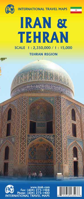
<p> Een degelijke kaart met aanduidingen van o.a. nationale parken, vliegveld, benzinepomp, dirt-roads en kleine plattegrond van hoofdstad. As overzichtskaart goed te gebruiken.</p> <p> In spite of being a controversial political entity, Iran is a fabulous touristic attraction. The fabled Blue Mosque of Mashhad graces our cover, unchanged in a changing world and a symbol of the reality that is today’s Iran. This version has been further updated by showing the new stretches of the motorway system and improving the readability of the map by softening our colours; printed double-sided on paper.</p> <p> A traveler's map of Iran at a scale of 1:2,350,000 with Tehran on the reverse at a scale of 1:15,000. With shaded topographic relief, index and information on key sites throughout the country</p> <p> </p>
€13,95
Bekijk product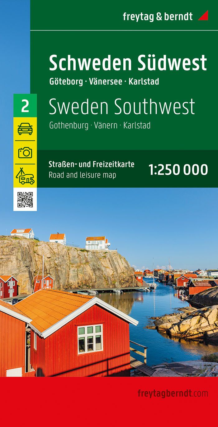
<p> Uitstekende autokaart van een deel van Zweden met veel informatie als campings, natuurgebieden, hoofd- en kleine wegen en veel bezienswaardigheden.</p> <div> De berijdbare wegen zijn goed weergeven, zowel de hoofdwegen als provinciale en lokale wegen; wegnummers worden vermeld. Afstanden tussen plaatsen zijn in kilometers op de kaart ingetekend, daarnaast worden ook op belangrijke plekken benzinepompen gemarkeerd.</div> <div> </div> <div> In het kaartbeeld wordt door middel van schaduw het reliëf weergegeven en soms enkele punten in het landschap met de daadwerkelijke hoogte. Provinciegrenzen zijn goed terug te vinden, nationale parken en reservaten ook. Met allerhande symbolen worden toeristische bezienswaardigheden weergegeven als monumenten, historisch belangrijke plekken en uitzichtpunten. In bepaalde plaatsen zijn hotels en campings te vinden, luchthavens, treinverbindingen en havens vindt u er ook op!</div> <div> </div> <div> Neben der übersichtlichen Gestaltung verfügt die Straßenkarte "Schweden Südwest, Straßen- und Freizeitkarte 1:250.000, freytag & berndt" über zahlreiche Zusatzinformationen wie z.B. Straßenbeschaffenheit, Sehenswürdigkeiten, Campingplätze und diverse Innenstadtpläne. Mit dem umfangreichen Ortsregister gelingt zudem eine rasche Orientierung. Sehenswürdigkeiten, Entfernungen in km, Campingplätze;</div>
€14,95
Bekijk product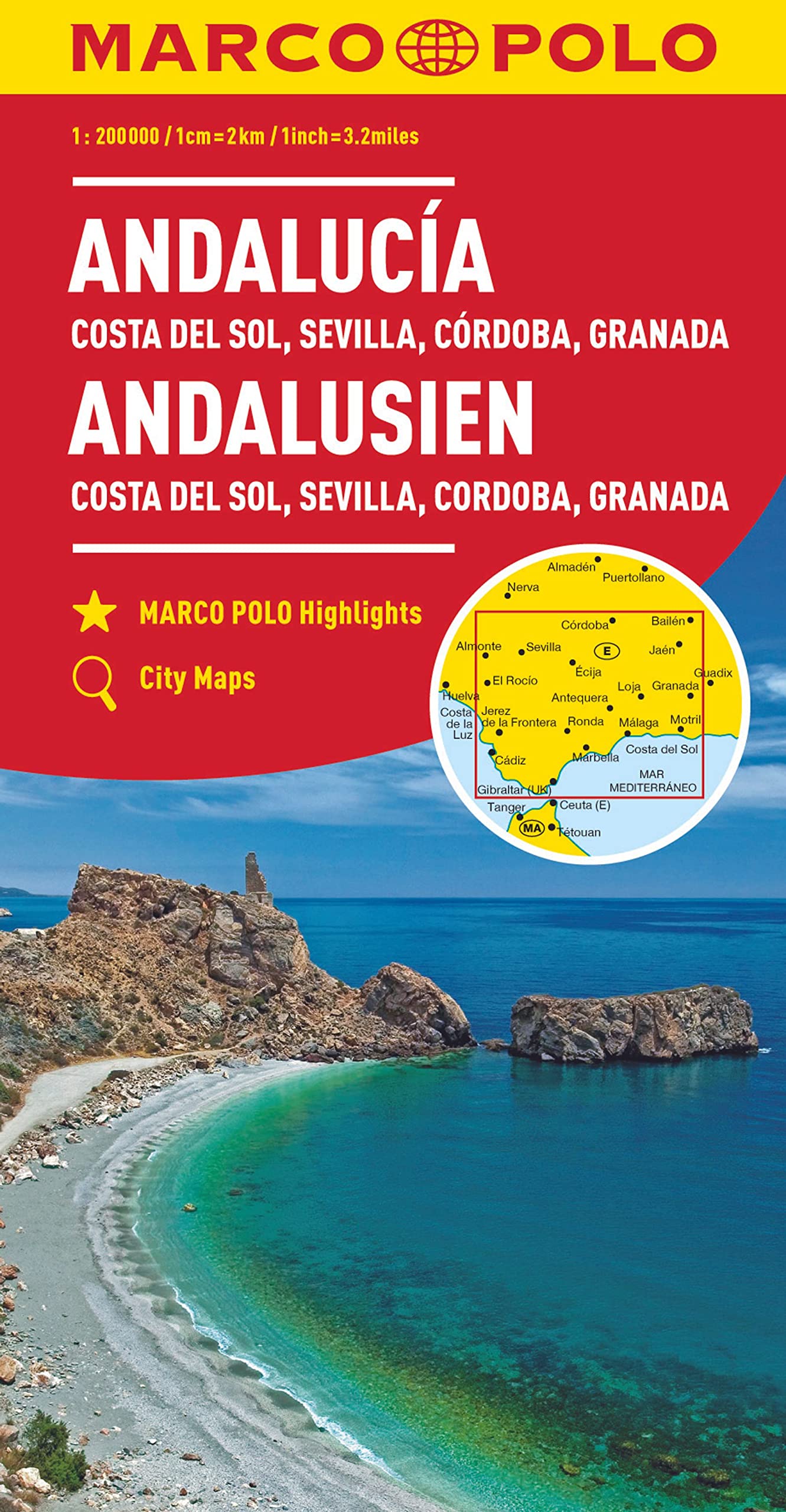
<p> Gedetailleerde kaart van Andalucie met goede aanduiding van alle berijdbare wegen, campings, bezienswaardigheden etc. Enigzins flets kleurgebruik, kaart oogt dan ook druk, maar er staat meer op dan de Michelin kaart.</p> <p> Hauptkarte im Maßstab 1:200 000; Übersichtskarte zum Ausklappen/ Entfernungstabelle/ Index: mehrsprachige Legende (E, D, GB, F, I, P, CZ, PL)/ Marco Polo Highlights/ 7 Citypläne: - Cádiz - Córdoba - Granada - Jaén - Jerez de la Frontera - Málaga - Sevilla/ Wichtige Verkehrsinformationen Spaniens/ Reiseinformationen/ Ortsregister mit Provinz, Postleitzahl und Suchfeldangabe</p>
€14,95
Bekijk product