
Beantwoord enkele vragen, en binnen seconden geeft AI je een persoonlijk aankoopadvies op maat.
Beantwoord enkele vragen, en binnen seconden geeft AI je een persoonlijk aankoopadvies op maat.
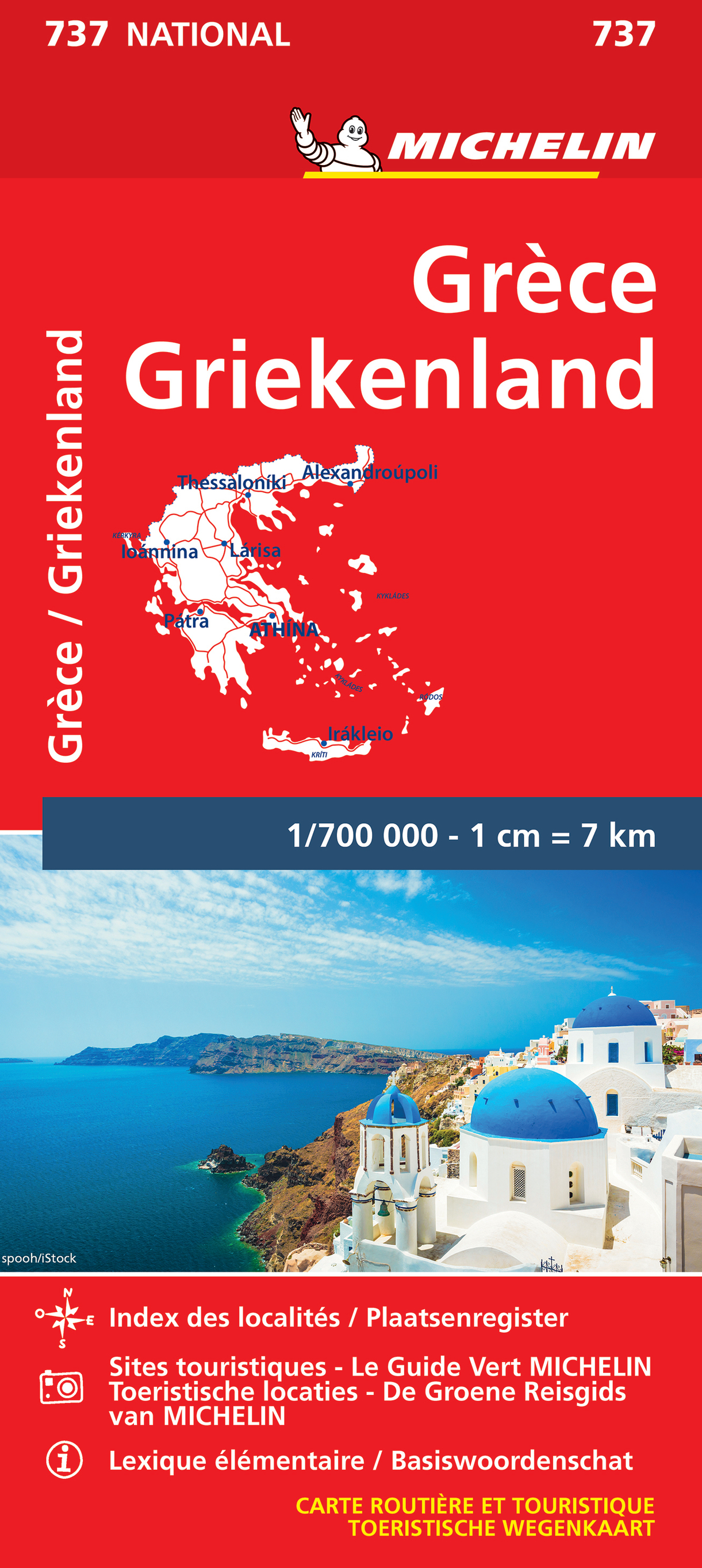
<div> Zoals je van Michelin mag verwachten is deze kaart zeer overzichtelijk en heeft een duidelijk helder kaartbeeld. De kaart geeft uitgebreid toeristische informatie weer. Met register, afstanden en reistijden.</div> <div> Wegen worden naar verschillende klasse ingedeeld en - mooi van Michelin - de interessante mooie routes worden gemarkeerd met een groene streep. </div> <div> </div> <div> Hindernissen voor automobilisten met caravans zijn gemarkeerd: steile hellingen, bergpassen of een anderzins moeilijke route. Bezienswaardigheden als een kasteel, religieus gebouw, ruine of grot is door een symbool goed te vinden.</div> <p style="line-height: 15px; margin-top: 0.5em; margin-right: 0px; margin-bottom: 0.5em; margin-left: 0px; padding-top: 0px; padding-right: 0px; padding-bottom: 0px; padding-left: 0px; font-family: verdana, arial, sans-serif; font-size: 11px; "> <span style="font-family: Arial, Verdana, sans-serif; font-size: 12px;">This Greece map from Michelin is part of their red national map series. These are perfect for route planning as well as getting around by car once you're there. They clearly mark out major roads and also show many of the more important minor roads.</span></p> <div> </div> <div> The map's simple folding design with durable paper cover, allows it to be read like a book and easily folded back together. Road numbers and intermediate distances are clearly displayed with the more scenic routes highlighted in green.</div> <div> </div> <div> The map also features:</div> <div> </div> <div> Political boundaries</div> <div> Regional and National Parks</div> <div> Important sights such as castles, ruins, and churches</div> <div> Driving Times and Distances</div> <div> Road Safety Information</div> <div> A legend in multiple languages (Dutch, English, French, German and Spanish)</div> <div> </div> <div> Athènes, Grèce continentale, Larissa, Météores, Patra, Thessalonique</div>
€11,95
Bekijk product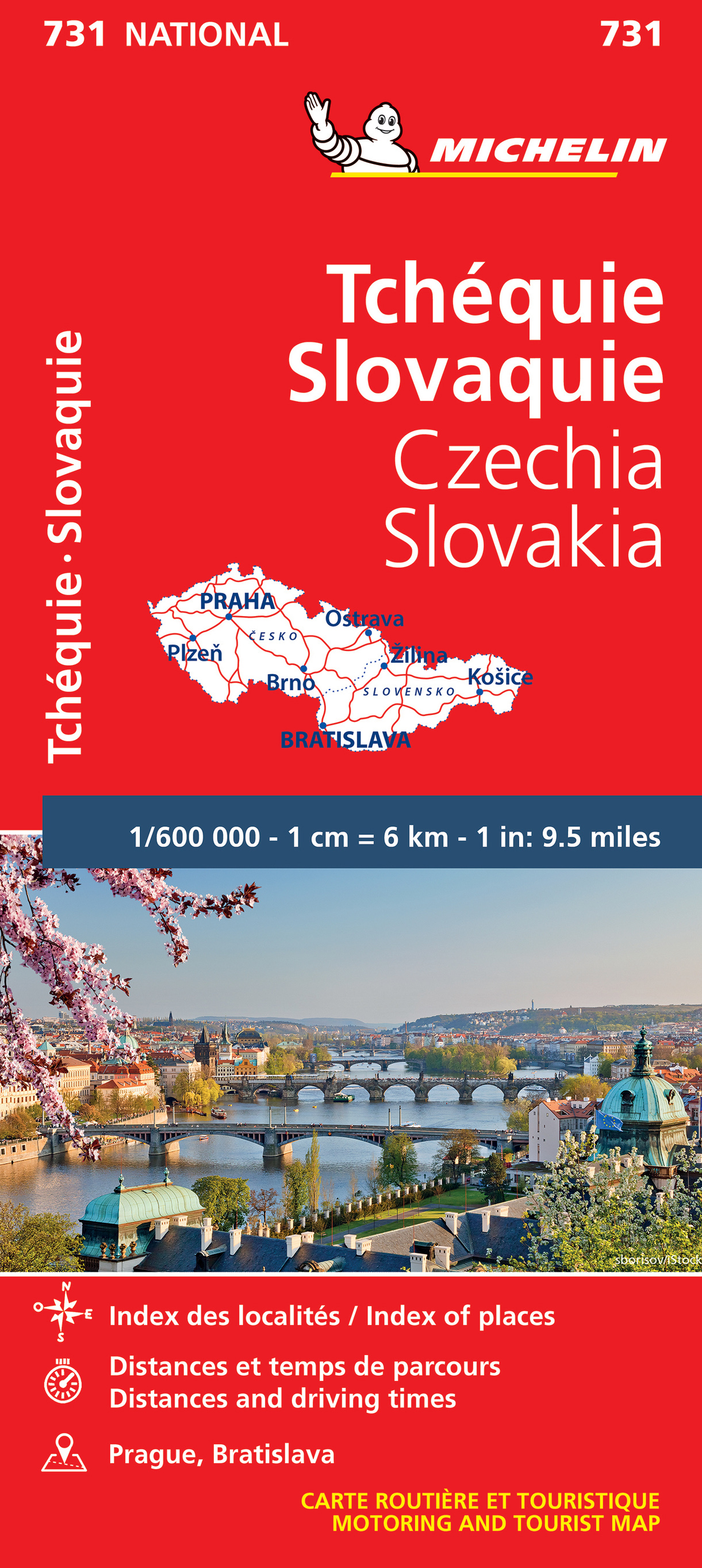
<div> Zoals je van Michelin mag verwachten is deze kaart zeer overzichtelijk en heeft een duidelijk helder kaartbeeld. De kaart geeft uitgebreid toeristische informatie weer. Met register, afstanden en reistijden.</div> <div> Wegen worden naar verschillende klasse ingedeeld en - mooi van Michelin - de interessante mooie routes worden gemarkeerd met een groene streep. </div> <div> </div> <div> Hindernissen voor automobilisten met caravans zijn gemarkeerd: steile hellingen, bergpassen of een anderzins moeilijke route. Bezienswaardigheden als een kasteel, religieus gebouw, ruine of grot is door een symbool goed te vinden.</div> <div> </div> <div> The Michelin National road map of the Czech and Slovak Republics at 1:600,000 scale is ideal for route planning and touring. The map gives comprehensive coverage of national road networks showing all major motorways, dual carriageways, national & regional main roads and most single-lane roads. The map is divided by grid showing latitude and logitude.</div> <div> </div> <div> Distances between major locations are marked along roads, with total distance and several intermediate distances shown. A quick-reference chart of distances & driving times between major locations is also included. The map also includes a grid-referenced index of principal place names.</div> <div> </div> <div> Clear, easy-to read cartography shows roads in reds, yellows and white with black outlines. Major topography is indicated with relief shading. Woodland & forest is marked with green shading. Built-up urban areas are clearly marked in yellow. Airports, ferries, railways are also marked. National and administrative divisions are marked, as are administrative district seats. Areas of special interest, such as churches and museums, are also displayed.</div> <div> </div> <div> City plan plans & regional enlargements:</div> <div> </div> <div> - Praque at 1:100,000 scale.</div> <div> <span style="font-size: 11px; line-height: 15px; ">- Bratislava at 1:100,000 scale.</span></div> <div> </div> <div> <span style="font-size: 11px; line-height: 15px; ">République Tchèque, Slovaquie</span></div>
€11,95
Bekijk product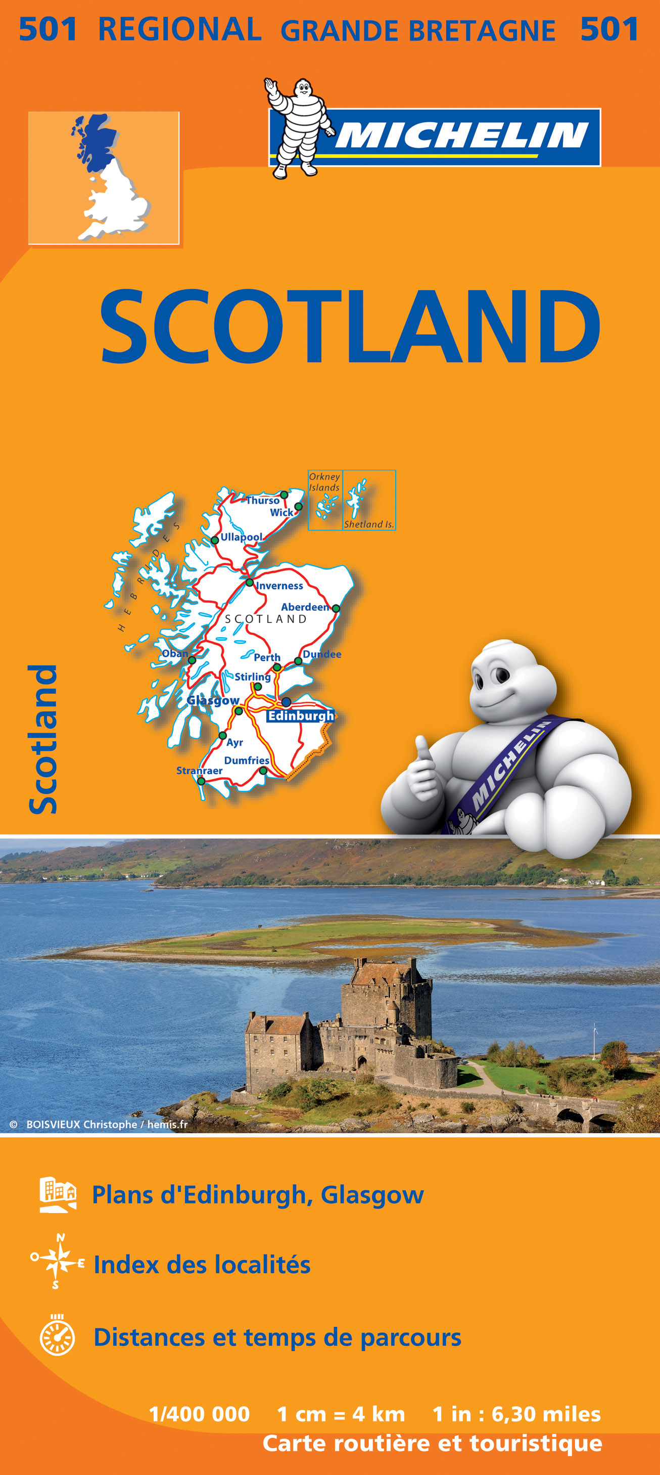
<p> <span style="font-size: 12px;">Zoals je van Michelin mag verwachten zijn het onmisbare overzichtskaarten van een uitstekende kwaliteit: een duidelijk en goed leesbaar kaartbeeld. Vrijwel alle berijdbare wegen staan er op ingetekend, in kleur verschillend voor grote en kleine wegen. Andere weginformatie omvat bijvoorbeeld kilometer-afstanden, tolwegen, helling-aanduiding, winterafsluitingen, tankstations maar ook de bekende groene routes: de mooiste wegen om te rijden.</span></p> <p> <span style="font-size: 12px;">Daarnaast geeft de kaart toeristische informatie met symbolen weer: bezienswaardigheden als kastelen, kloosters, musea, maar ook campings (niet allemaal overigens). De kaart is voorzien van een 4-talige legenda. </span></p> <p> <span style="font-size: 12px;">Toch hebben de makers door een beperkt gebruik van symbolen geen drukke kaart gemaakt. De kracht zit hem dan ook in de combinatie van meer dan voldoende informatie en goede leesbaarheid. </span></p> <p> Ecosse</p>
€11,95
Bekijk product
<p> Goede wegenkaart van Banff & Jasper met bezienswaardigheden, Overnachtingsmogelijkheden, Campings en hete bronnen.</p> <p> This is our most popular driving (touring) map and the map most recommended as an overview for anyone planning a trip to the Canadian Rocky Mountain Parks - Banff, Jasper, Yoho and Kootenay. It also covers Mount Revelstoke and Glacier national parks, the Bugaboos and the Purcell Mountains further west. </p> <div> 29 of the best points of interest in the Rocky Mountain Parks are numbered and described. Mountain lodges, campgrounds, hostels, hot springs, golf courses, ski areas, picnic sites, visitor centres and highway viewpoints are labelled.</div> <div> The mountains are also labelled with their name and elevation, if available, and glaciers are easy to pick out because they are shown in a different colour. </div> <div> On the back, you will find a map of Western Canada showing all the major highways, as well as maps showing the major arteries in the cities of Edmonton and Calgary. There are also town maps of Banff, Jasper and Lake Louise. Points of interest are numbered and described on the Edmonton, Calgary, Banff, Jasper and Lake Louise town maps. There is also a guide to campgrounds in Banff, Jasper, Yoho and Kootenay National Parks. </div> <div> Pretty much everything that visitors to Canadian Rockies need to know - all on one map.</div>
€13,95
Bekijk product
<p> Goede wegenkaart van British Columbia met Nationale Parken, Overnachtingsmogelijkheden, Ski gebieden en bezienswaardigheden.</p> <div> Gem Trek’s Southwest British Columbia & Northern Washington map meets the needs of visitors looking to explore the lower mainland of British Columbia and the northern section of Washington state.</div> <div> </div> <div> All the major highways are shown, as well as national, provincial, and state parks and wilderness areas. The map also shows lesser-known back roads, and pinpoints the location of lodges, campgrounds and hot springs. Mileage charts on the front and back provide distances between major towns and cities.</div> <div> </div> <div> The Southwest British Columbia & Northern Washington map covers all of Vancouver Island and extends west through the city of Vancouver and the Okanagan Valley to the Kootenays. South of the border, Washington state is covered from the Gulf Islands in the west to Spokane in the east, with coverage as far south as Mount Rainer National Park.</div> <div> </div> <div> <div> The Southwest British Columbia & Northern Washington map includes:</div> <div> </div> <div> full colour on both sides</div> <div> national and provincial parks</div> <div> cities, towns, and villages</div> <div> campgrounds</div> </div> <p> </p>
€8,95
Bekijk product
<p> Uitstekende deelkaart van Italie met als basis een bijna topografische ondergrond. Mooie wegen staan met groen weergegeven en groot voordeel boven de Michelin en Kummerley/Frey series is het feit dat er -weliswaar klein - campings op staan ingetekend. Zeer leesbare kaart, met register en alle noodzakelijke informatie.</p> <p> The series is particularly good for identifying geographical features: mountain and hill chains, valleys, national parks, etc. Picturesque towns and places of interest are given star rating, and other tourist information includes campsites and youth hostels, landmarks, recreational facilities etc. Latitude and longitude grid is drawn at intervals of 10'.</p> <p> Each title comes with a booklet which contains a street plan of the central area in the region’s main city, plus an extensive index of place names, including geographical features. Also provided are a table with distances and traveling times and main traffic and speed regulations. Map legend and all information include English.</p> <p> </p>
€14,95
Bekijk product
<p> Uitstekende deelkaart van Italie met als basis een bijna topografische ondergrond. Mooie wegen staan met groen weergegeven en groot voordeel boven de Michelin en Kummerley/Frey series is het feit dat er -weliswaar klein - campings op staan ingetekend. Zeer leesbare kaart, met register en alle noodzakelijke informatie.</p> <p> The series is particularly good for identifying geographical features: mountain and hill chains, valleys, national parks, etc. Picturesque towns and places of interest are given star rating, and other tourist information includes campsites and youth hostels, landmarks, recreational facilities etc. Latitude and longitude grid is drawn at intervals of 10'.</p> <p> </p> <p> </p>
€14,95
Bekijk product
<p> Uitstekende wegenkaart van een klein gebied tussen Split en Murter aan de Dalmatische kust van Kroatie. Zeer gedetailleerde kaart met hoogtelijnen en andere topografische details, maar ook campings. Ideaal om deze eilanden per boot of auto / fiets te ontdekken.</p> <p> <span style="font-size: 12px;">Coverage includes Sibenik, Trogir and the islands of Solta and Vis. The map shows local roads, highlighting scenic routes, and indicates ferry connections. Icons mark various facilities such as campsites, beaches and marinas, as well as places of interest. </span></p>
€14,95
Bekijk product
<p> Gedetailleerde wegenkaart met aanduiding van de wandelwegen, lijst van hotels en toeristische informatie. Voor alle doeleinden een zeer geschikte kaart. Scheur- en watervast!</p> <p> The features that make this and every other ROAD island map unique are:<br /> *The coastline, hydrography and precision geophysical background based on data provided by the Hellenic Military Geographic Service and electronically processed by us for clarity and legibility. We have highlighted the mountain masses in shades of brown between the contour lines (at 100m intervals on this map) to outline clearly the relief of the island.<br /> *The beaches are indicated by a special symbol next to which we have noted their names, as well as all the roads and footpaths leading to them (since most people primarily visit the islands for the beaches!). We have even included a short text in which the island’s best beaches are concisely referred to, to save you going on a wild goose hunt in search of them.<br /> *The road network is mapped out with impressive and exemplary thoroughness and is updated in each new edition – thoroughness being a trait ROAD is internationally famous for. Even the most insignificant secondary and blind unsurfaced roads are charted (so that you know where not to turn!), the scenic routes are highlighted in green (telling you where you should turn!), with precision distances in kilometres from intersection to intersection, to allow you to track your course with greater ease.<br /> *The island's major footpaths are clearly charted.<br /> *The monasteries, country churches, archaeological sites, lighthouses, caves and many more places of interest, are marked with great accuracy.<br /> *Short texts (in Greek and English) that present the history, the island as it is today, the local products and the most important things to know about the island.<br /> *On the back of the map, there is a complete listing of the accommodations on the island, useful telephone numbers, information about local transport schedules, and more.</p>
€9,95
Bekijk product
<p> Gedetailleerde wegenkaart met aanduiding van de wandelwegen, lijst van hotels en toeristische informatie. Voor alle doeleinden een zeer geschikte kaart.</p> <p> The features that make this and every other ROAD island map unique are:<br /> *The coastline, hydrography and precision geophysical background based on data provided by the Hellenic Military Geographic Service and electronically processed by us for clarity and legibility. We have highlighted the mountain masses in shades of brown between the contour lines (at 20m intervals on this map) to outline clearly the relief of the island.<br /> *The beaches are indicated by a special symbol next to which we have noted their names, as well as all the roads and footpaths leading to them (since most people primarily visit the islands for the beaches!). We have even included a short text in which the island’s best beaches are concisely referred to, to save you going on a wild goose hunt in search of them.<br /> *The road network is mapped out with impressive and exemplary thoroughness and is updated in each new edition – thoroughness being a trait ROAD is internationally famous for. Even the most insignificant secondary and blind unsurfaced roads are charted (so that you know where not to turn!), the scenic routes are highlighted in green (telling you where you should turn!), with precision distances in kilometres from intersection to intersection, to allow you to track your course with greater ease.<br /> *The island’s major footpaths are clearly charted.<br /> *The monasteries, country churches, archaeological sites, lighthouses, caves and many more places of interest, are marked with great accuracy.<br /> *Short texts (in Greek and English) that present the history, the island as it is today, the local products and the most important things to know about the island.<br /> *On the back of the map, which is also in colour, there is a complete listing of the accommodations on the island, useful telephone numbers, information about local transport schedules etc., as well as a short tour of the island and many photographs of characteristic Sifnos landscapes.</p>
€9,95
Bekijk product